TopoQuest Logo
Do you find TopoQuest useful?
Help keep TopoQuest running and adding new maps/features by donating!
Bitcoin:  19c7KJd3qBynnjoSw5npx9KScwjBe4ifkT
Litecoin:  LXs6TkuXGGXo1vDsWCkWVdjQX94eUKd6ui
Home View Maps Find Maps Find Places Resources & Links


Seaton, Texas Topographic Map

USGS Map Title: Seaton, TX
USGS Map MRC: 31097A2
DRG (GeoTIFF) Download: o31097a2.tif


Neighboring USGS Topographic Map Quads:


  Troy, TX  
31097B3
 

  Belfalls, TX  
31097B2
 

  Lott, TX  
31097B1
 

  Temple, TX  
31097A3
 

  Seaton, TX  
31097A2
 

  Westphalia, TX  
31097A1
 

  Little River, TX  
30097H3
 

  Rogers, TX  
30097H2
 

  Yarrelton, TX  
30097H1


Map MRC Location:

N32°
W98°
N32°
W97°
H8 H7 H6 H5 H4 H3 H2 H1
G8 G7 G6 G5 G4 G3 G2 G1
F8 F7 F6 F5 F4 F3 F2 F1
E8 E7 E6 E5 E4 E3 E2 E1
D8 D7 D6 D5 D4 D3 D2 D1
C8 C7 C6 C5 C4 C3 C2 C1
B8 B7 B6 B5 B4 B3 B2 B1
A8 A7 A6 A5 A4 A3 A2 A1
N31°
W98°
N31°
W97°

Seaton, TX USGS 1:24K Topographic Map Preview:
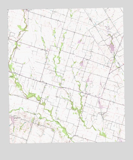
Seaton, TX USGS Topographic Map
Click on map above to begin viewing in our Map Viewer.

This topographic map contains these locations and features:
Feature Name Type Latitude Longitude GNIS ID View Map
AirvillePopulated PlaceN31.0771°W97.1636°1379327View Map
ContentLocaleN31.0846°W97.1606°1354891View Map
Cottonwood CreekStreamN31.0621°W97.2456°1355092View Map
CyclonePopulated PlaceN31.0277°W97.1508°1379626View Map
Cyclone BranchStreamN31.0082°W97.1492°1355510View Map
Dyess CemeteryCemeteryN31.0171°W97.2175°1356513View Map
Dyess Grove ChurchChurchN31.0238°W97.2419°1356514View Map
East Highway Baptist ChurchChurchN31.0649°W97.2403°2016454View Map
East Highway ChurchChurchN31.0638°W97.2378°1356647View Map
Lesikar Farms Airport (historical)AirportN31.0252°W97.1858°1387619View Map
Little Elm CreekStreamN31.0213°W97.2022°1361348View Map
Lost Prairie SchoolSchoolN31.0907°W97.2264°1361842View Map
Marek LakeReservoirN31.0550°W97.1511°1865210View Map
Marek Lake DamDamN31.0552°W97.1503°1865209View Map
OckerPopulated PlaceN31.0707°W97.1436°1380283View Map
Ocker ChurchChurchN31.0432°W97.1567°1364334View Map
Pecan CreekStreamN31.1249°W97.2328°1364965View Map
Possum CreekStreamN31.0288°W97.1747°1365622View Map
RatiborPopulated PlaceN31.0874°W97.2125°1380413View Map
Ratibor BranchStreamN31.0693°W97.2000°1366023View Map
Red RangerPopulated PlaceN31.0066°W97.1803°1380424View Map
Salt CreekStreamN31.0682°W97.1994°1367399View Map
SeatonPopulated PlaceN31.0577°W97.2161°1367911View Map
Seaton CemeteryCemeteryN31.0541°W97.2114°1363606View Map
StringtownPopulated PlaceN31.0238°W97.2411°1380619View Map
ZabcikvillePopulated PlaceN31.0452°W97.1667°1372078View Map

Note: Coordinates in the location and feature list above are referenced to NAD83 datum.


Copyright (C) 2008-2024 Ryan Niemi / Sunset Dynamics ... All Rights Reserved