TopoQuest Logo
Do you find TopoQuest useful?
Help keep TopoQuest running and adding new maps/features by donating!
Bitcoin:  19c7KJd3qBynnjoSw5npx9KScwjBe4ifkT
Litecoin:  LXs6TkuXGGXo1vDsWCkWVdjQX94eUKd6ui
Home View Maps Find Maps Find Places Resources & Links


Westphalia, Texas Topographic Map

USGS Map Title: Westphalia, TX
USGS Map MRC: 31097A1
DRG (GeoTIFF) Download: o31097a1.tif


Neighboring USGS Topographic Map Quads:


  Belfalls, TX  
31097B2
 

  Lott, TX  
31097B1
 

  Cedar Springs, TX  
31096B8
 

  Seaton, TX  
31097A2
 

  Westphalia, TX  
31097A1
 

  Rosebud, TX  
31096A8
 

  Rogers, TX  
30097H2
 

  Yarrelton, TX  
30097H1
 

  Ben Arnold, TX  
30096H8


Map MRC Location:

N32°
W98°
N32°
W97°
H8 H7 H6 H5 H4 H3 H2 H1
G8 G7 G6 G5 G4 G3 G2 G1
F8 F7 F6 F5 F4 F3 F2 F1
E8 E7 E6 E5 E4 E3 E2 E1
D8 D7 D6 D5 D4 D3 D2 D1
C8 C7 C6 C5 C4 C3 C2 C1
B8 B7 B6 B5 B4 B3 B2 B1
A8 A7 A6 A5 A4 A3 A2 A1
N31°
W98°
N31°
W97°

Westphalia, TX USGS 1:24K Topographic Map Preview:
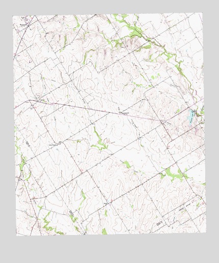
Westphalia, TX USGS Topographic Map
Click on map above to begin viewing in our Map Viewer.

This topographic map contains these locations and features:
Feature Name Type Latitude Longitude GNIS ID View Map
BarclayPopulated PlaceN31.0766°W97.1094°1351499View Map
Barclay CemeteryCemeteryN31.0730°W97.1128°1351501View Map
Bluebonnet CemeteryCemeteryN31.0602°W97.0078°1385352View Map
Brushy CreekStreamN31.0491°W97.0650°1353037View Map
Cactus BranchStreamN31.1168°W97.0450°1353498View Map
City of Rosebud DamDamN31.0685°W97.0069°1856292View Map
Keys CreekStreamN31.0335°W97.0239°1360611View Map
Krause LakeReservoirN31.0918°W97.0919°1864115View Map
Krause Lake DamDamN31.0918°W97.0919°1864114View Map
McLennans Bluff Historical MarkerParkN31.0671°W97.0061°1385353View Map
Rosebud LakeReservoirN31.0672°W97.0089°1366871View Map
Saint Joseph CemeteryCemeteryN31.0324°W97.1236°1367197View Map
Saint Marys CemeteryCemeteryN31.1230°W97.1172°1367261View Map
Salem ChurchChurchN31.0530°W97.0961°1367356View Map
Smith LakeReservoirN31.0583°W97.0057°1864117View Map
Smith Lake DamDamN31.0602°W97.0053°1864116View Map
Terry ChapelPopulated PlaceN31.0532°W97.0933°2034769View Map
Terry ChapelLocaleN31.0513°W97.0980°1369743View Map
WestphaliaPopulated PlaceN31.1191°W97.1153°1371303View Map
Westphalia Rural Historic DistrictLocaleN31.1210°W97.1156°2031903View Map
WilsonPopulated PlaceN31.0180°W97.0644°1380790View Map
WilsonPopulated PlaceN31.0182°W97.0639°2034733View Map
ZipperlandvillePopulated PlaceN31.0688°W97.0553°1380813View Map

Note: Coordinates in the location and feature list above are referenced to NAD83 datum.


Copyright (C) 2008-2025 Ryan Niemi / Sunset Dynamics ... All Rights Reserved