TopoQuest Logo
Do you find TopoQuest useful?
Help keep TopoQuest running and adding new maps/features by donating!
Bitcoin:  19c7KJd3qBynnjoSw5npx9KScwjBe4ifkT
Litecoin:  LXs6TkuXGGXo1vDsWCkWVdjQX94eUKd6ui
Home View Maps Find Maps Find Places Resources & Links


Bissell, Mississippi Topographic Map

USGS Map Title: Bissell, MS
USGS Map MRC: 34088B7
DRG (GeoTIFF) Download: o34088b7.tif


Neighboring USGS Topographic Map Quads:


  Northeast Pontotoc, MS  
34088C8
 

  Sherman, MS  
34088C7
 

  Tupelo, MS  
34088C6
 

  Southeast Pontotoc, MS  
34088B8
 

  Bissell, MS  
34088B7
 

  Verona, MS  
34088B6
 

  Troy, MS  
34088A8
 

  Troy SE, MS  
34088A7
 

  Shannon, MS  
34088A6


Map MRC Location:

N35°
W89°
N35°
W88°
H8 H7 H6 H5 H4 H3 H2 H1
G8 G7 G6 G5 G4 G3 G2 G1
F8 F7 F6 F5 F4 F3 F2 F1
E8 E7 E6 E5 E4 E3 E2 E1
D8 D7 D6 D5 D4 D3 D2 D1
C8 C7 C6 C5 C4 C3 C2 C1
B8 B7 B6 B5 B4 B3 B2 B1
A8 A7 A6 A5 A4 A3 A2 A1
N34°
W89°
N34°
W88°

Bissell, MS USGS 1:24K Topographic Map Preview:
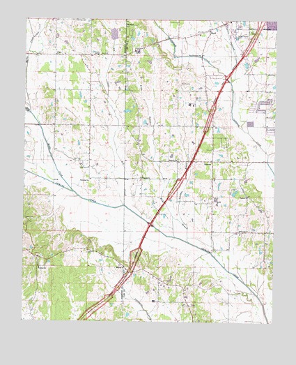
Bissell, MS USGS Topographic Map
Click on map above to begin viewing in our Map Viewer.

This topographic map contains these locations and features:
Feature Name Type Latitude Longitude GNIS ID View Map
Allens CemeteryCemeteryN34.2279°W88.7548°666217View Map
Ballard ParkParkN34.2493°W88.7659°686936View Map
Bass CemeteryCemeteryN34.1920°W88.8503°666560View Map
Big Hill Methodist ChurchChurchN34.2479°W88.8245°667115View Map
BissellPopulated PlaceN34.2462°W88.7828°667190View Map
Bissell Baptist ChurchChurchN34.2296°W88.7834°686949View Map
Black Land School (historical)SchoolN34.1779°W88.7645°686950View Map
Blackland ChurchChurchN34.1776°W88.7639°667248View Map
Cedar CovePopulated PlaceN34.1890°W88.7653°686963View Map
Chiwapa Struture 29 DamDamN34.2418°W88.8317°682534View Map
Coonewar (historical)LocaleN34.2354°W88.8484°684701View Map
Country Oak EstatesPopulated PlaceN34.2362°W88.8326°684702View Map
Dry CreekStreamN34.1732°W88.8248°669447View Map
Fawn MeadowsPopulated PlaceN34.2334°W88.8626°684706View Map
Fellowship ChurchChurchN34.1832°W88.8426°669941View Map
Fred Anderson DamDamN34.2234°W88.7517°682516View Map
FurrsPopulated PlaceN34.2351°W88.8601°670275View Map
Furrs Baptist ChurchChurchN34.2357°W88.8556°684707View Map
Furrs Volunteer Fire DepartmentBuildingN34.2317°W88.8464°2665968View Map
Galilean Baptist ChurchChurchN34.2171°W88.7839°684478View Map
Garmons Mill (historical)LocaleN34.1540°W88.7803°684479View Map
Gormans BranchStreamN34.1659°W88.7942°670542View Map
Haven AcresPopulated PlaceN34.2146°W88.7542°684491View Map
League CreekStreamN34.2426°W88.8712°672340View Map
Little Coonewah CreekStreamN34.2243°W88.7726°672574View Map
Mallory Family CemeteryCemeteryN34.1854°W88.7639°706767View Map
Metcalf School (historical)SchoolN34.2109°W88.7809°684527View Map
Miller CreekStreamN34.2112°W88.8720°673643View Map
Mubby CreekStreamN34.1787°W88.8503°674423View Map
Natchez Trace ParkwayParkN34.1864°W88.7954°123648View Map
New Zion CemeteryCemeteryN34.2498°W88.8453°684719View Map
Oak Valley ChurchChurchN34.1629°W88.7673°675107View Map
Old Coffee CemeteryCemeteryN34.1465°W88.8237°706779View Map
PalmettoPopulated PlaceN34.1918°W88.7809°675413View Map
Palmetto Baptist ChurchChurchN34.1840°W88.7801°684547View Map
Palmetto CemeteryCemeteryN34.1845°W88.8162°706787View Map
Palmetto CemeteryCemeteryN34.1923°W88.7984°684548View Map
Palmetto ChurchChurchN34.1923°W88.7989°675416View Map
Palmetto EstatesPopulated PlaceN34.2009°W88.7759°684549View Map
Palmetto Methodist ChurchChurchN34.1848°W88.8159°675415View Map
Palmetto School (historical)SchoolN34.1979°W88.7812°684550View Map
Philips CemeteryCemeteryN34.2451°W88.7606°675684View Map
Pontocola (historical)LocaleN34.1454°W88.8217°684561View Map
Pontocola CemeteryCemeteryN34.1534°W88.8428°676197View Map
Pontocola ChurchChurchN34.1476°W88.8248°676198View Map
Pontocola School (historical)SchoolN34.1473°W88.8242°706795View Map
Praise AcresPopulated PlaceN34.1973°W88.8189°684564View Map
Reeds BranchStreamN34.1582°W88.7926°676565View Map
Spearman FieldAirportN34.1559°W88.7603°2676390View Map
Spring Lake DamDamN34.2368°W88.7584°682529View Map
Supervisor District 4CivilN34.1599°W88.7642°711956View Map
Tranquil School (historical)SchoolN34.1348°W88.7931°684605View Map
Valley Grove ChurchChurchN34.1890°W88.8428°679173View Map
West Moreland CemeteryCemeteryN34.2354°W88.7878°679511View Map
Woodland SchoolSchoolN34.1471°W88.8664°679848View Map
Zion ChurchChurchN34.2359°W88.8342°680001View Map

Note: Coordinates in the location and feature list above are referenced to NAD83 datum.


Copyright (C) 2008-2024 Ryan Niemi / Sunset Dynamics ... All Rights Reserved