TopoQuest Logo
Do you find TopoQuest useful?
Help keep TopoQuest running and adding new maps/features by donating!
Bitcoin:  19c7KJd3qBynnjoSw5npx9KScwjBe4ifkT
Litecoin:  LXs6TkuXGGXo1vDsWCkWVdjQX94eUKd6ui
Home View Maps Find Maps Find Places Resources & Links


Shannon, Mississippi Topographic Map

USGS Map Title: Shannon, MS
USGS Map MRC: 34088A6
DRG (GeoTIFF) Download: o34088a6.tif


Neighboring USGS Topographic Map Quads:


  Bissell, MS  
34088B7
 

  Verona, MS  
34088B6
 

  Evergreen, MS  
34088B5
 

  Troy SE, MS  
34088A7
 

  Shannon, MS  
34088A6
 

  Nettleton, MS  
34088A5
 

  Buena Vista, MS  
33088H7
 

  Egypt, MS  
33088H6
 

  Wren, MS  
33088H5


Map MRC Location:

N35°
W89°
N35°
W88°
H8 H7 H6 H5 H4 H3 H2 H1
G8 G7 G6 G5 G4 G3 G2 G1
F8 F7 F6 F5 F4 F3 F2 F1
E8 E7 E6 E5 E4 E3 E2 E1
D8 D7 D6 D5 D4 D3 D2 D1
C8 C7 C6 C5 C4 C3 C2 C1
B8 B7 B6 B5 B4 B3 B2 B1
A8 A7 A6 A5 A4 A3 A2 A1
N34°
W89°
N34°
W88°

Shannon, MS USGS 1:24K Topographic Map Preview:
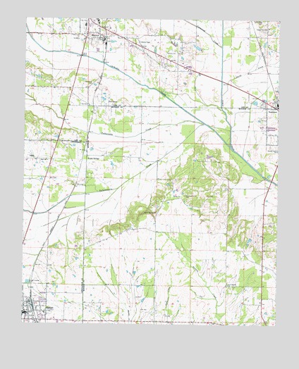
Shannon, MS USGS Topographic Map
Click on map above to begin viewing in our Map Viewer.

This topographic map contains these locations and features:
Feature Name Type Latitude Longitude GNIS ID View Map
Bertersville (historical)LocaleN34.0962°W88.7289°686937View Map
Black Oak ChurchChurchN34.0673°W88.7389°667237View Map
Blackwell Church (historical)ChurchN34.0009°W88.6859°687365View Map
Blackwood Grove Baptist ChurchChurchN34.0457°W88.6845°667257View Map
Blackwood Grove CemeteryCemeteryN34.0529°W88.6706°667256View Map
Calvary Baptist ChurchChurchN34.0526°W88.6728°667946View Map
Calvary Baptist ChurchChurchN34.0071°W88.7489°710262View Map
Camargo (historical)Populated PlaceN34.0709°W88.6487°709319View Map
Camargo Ferry (historical)CrossingN34.0723°W88.6478°709320View Map
Chickasaw Switch (historical)LocaleN34.0709°W88.7203°688706View Map
Chiwapa CreekStreamN34.0729°W88.6487°692896View Map
Church of God of ProphecyChurchN34.0087°W88.7401°688707View Map
City of OkolonaCivilN34.0053°W88.7479°2404425View Map
Coggin SubdivisionPopulated PlaceN34.0807°W88.6287°687377View Map
Coonewah CreekStreamN34.1134°W88.6534°668804View Map
Dotys ChapelChurchN34.1121°W88.6912°708979View Map
Dotys Chapel CemeteryCemeteryN34.1118°W88.6912°708980View Map
Family Baptist ChurchChurchN34.1165°W88.7214°686989View Map
First Baptist Church of ShannonChurchN34.1187°W88.7309°686995View Map
First Christian ChurchChurchN34.0034°W88.7498°688710View Map
Johnsons ChapelChurchN34.1157°W88.6939°671950View Map
LeotisPopulated PlaceN34.0673°W88.7434°672406View Map
New Prospect CemeteryCemeteryN34.0170°W88.6492°709366View Map
New Prospect ChurchChurchN34.0165°W88.6489°674814View Map
North Gatlin Street Church of ChristChurchN34.0054°W88.7473°688723View Map
Okolona Fire DepartmentBuildingN34.0049°W88.7454°2665687View Map
Okolona First Baptist ChurchChurchN34.0040°W88.7470°710346View Map
Okolona Municipal Airport-Richard Stovall FieldAirportN34.0153°W88.7273°2676393View Map
Okolona Police DepartmentBuildingN34.0047°W88.7462°2754091View Map
Pine GrovePopulated PlaceN34.0893°W88.7089°675809View Map
Pine Grove Baptist ChurchChurchN34.0896°W88.7181°675852View Map
Pine Grove CemeteryCemeteryN34.0982°W88.7173°675817View Map
Poplar SpringsPopulated PlaceN34.0690°W88.7189°676233View Map
Poplar Springs Methodist ChurchChurchN34.0684°W88.7187°687452View Map
Saint John Missionary Baptist ChurchChurchN34.1209°W88.7234°684575View Map
Saint Theresa Catholic ChurchChurchN34.0018°W88.7484°688734View Map
ShannonPopulated PlaceN34.1162°W88.7117°677612View Map
Shannon CemeteryCemeteryN34.1215°W88.7098°706806View Map
Shannon Elementary SchoolSchoolN34.1243°W88.7145°706807View Map
Shannon Methodist ChurchChurchN34.1171°W88.7309°684587View Map
Shannon Police DepartmentBuildingN34.1174°W88.7122°2754271View Map
Shannon Post OfficePost OfficeN34.1207°W88.7187°2768721View Map
Shannon SchoolSchoolN34.1223°W88.7203°706808View Map
Shannon Volunteer Fire DepartmentBuildingN34.1173°W88.7119°2665698View Map
Smith CreekStreamN34.0943°W88.6531°677928View Map
Tallabinnela CreekStreamN34.0821°W88.6609°694928View Map
Temple Grove ChurchChurchN34.1212°W88.6314°678618View Map
Temples CemeteryCemeteryN34.1109°W88.6803°678620View Map
Town of ShannonCivilN34.1144°W88.6931°2407320View Map
Tubbalubba CreekStreamN34.0823°W88.6614°695011View Map
Whiteside Family CemeteryCemeteryN34.1162°W88.7084°706825View Map
Willgo CreekStreamN34.0540°W88.7131°695181View Map

Note: Coordinates in the location and feature list above are referenced to NAD83 datum.


Copyright (C) 2008-2025 Ryan Niemi / Sunset Dynamics ... All Rights Reserved