TopoQuest Logo
Do you find TopoQuest useful?
Help keep TopoQuest running and adding new maps/features by donating!
Bitcoin:  19c7KJd3qBynnjoSw5npx9KScwjBe4ifkT
Litecoin:  LXs6TkuXGGXo1vDsWCkWVdjQX94eUKd6ui
Home View Maps Find Maps Find Places Resources & Links


Bithlo, Florida Topographic Map

USGS Map Title: Bithlo, FL
USGS Map MRC: 28081E1
DRG (GeoTIFF) Download: o28081e1.tif


Neighboring USGS Topographic Map Quads:


  Oviedo, FL  
28081F2
 

  Geneva, FL  
28081F1
 

  Aurantia, FL  
28080F8
 

  Oviedo SW, FL  
28081E2
 

  Bithlo, FL  
28081E1
 

  Titusville SW, FL  
28080E8
 

  Narcoossee NW, FL  
28081D2
 

  Narcoossee NE, FL  
28081D1
 

  Lake Poinsett NW, FL  
28080D8


Map MRC Location:

N29°
W82°
N29°
W81°
H8 H7 H6 H5 H4 H3 H2 H1
G8 G7 G6 G5 G4 G3 G2 G1
F8 F7 F6 F5 F4 F3 F2 F1
E8 E7 E6 E5 E4 E3 E2 E1
D8 D7 D6 D5 D4 D3 D2 D1
C8 C7 C6 C5 C4 C3 C2 C1
B8 B7 B6 B5 B4 B3 B2 B1
A8 A7 A6 A5 A4 A3 A2 A1
N28°
W82°
N28°
W81°

Bithlo, FL USGS 1:24K Topographic Map Preview:
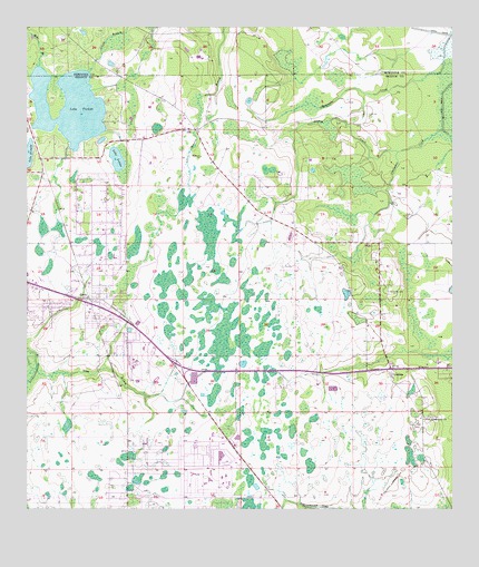
Bithlo, FL USGS Topographic Map
Click on map above to begin viewing in our Map Viewer.

This topographic map contains these locations and features:
Feature Name Type Latitude Longitude GNIS ID View Map
Big T Mobile Home ParkPopulated PlaceN28.5465°W81.0987°2451515View Map
BithloPopulated PlaceN28.5547°W81.1065°278870View Map
Bithlo Census Designated PlaceCensusN28.5644°W81.1067°2402690View Map
Cedarhurst Mobile Home ParkPopulated PlaceN28.5668°W81.1080°2451518View Map
ChristmasPopulated PlaceN28.5364°W81.0176°280429View Map
Christmas CemeteryCemeteryN28.5567°W81.0184°280431View Map
Christmas Census Designated PlaceCensusN28.5606°W81.0201°2402771View Map
Christmas ParkParkN28.5611°W81.0220°299950View Map
Christmas Post OfficePost OfficeN28.5358°W81.0192°2480342View Map
Deharts Trailer ParkPopulated PlaceN28.5420°W81.1009°2451522View Map
First Baptist Church of BithloChurchN28.5512°W81.1049°2479773View Map
First Missionary Baptist Church of BithloChurchN28.5531°W81.1081°299102View Map
First Missionary ChurchChurchN28.5236°W81.0078°282465View Map
Fort Christmas (historical)MilitaryN28.5333°W81.0167°294549View Map
Holiday Acres Mobile Home ParkPopulated PlaceN28.5519°W81.1198°2451531View Map
Iglesia de dios BithloChurchN28.5710°W81.1014°2479833View Map
J and C Mobile Home ParkPopulated PlaceN28.5595°W81.1104°2451571View Map
Joshua CreekStreamN28.5931°W81.0156°284947View Map
Lake DrawdyLakeN28.5919°W81.1248°281753View Map
Lake LouiseLakeN28.5909°W81.0985°286142View Map
Lake PickettLakeN28.6046°W81.1125°288777View Map
Lake PickettPopulated PlaceN28.5911°W81.1190°299951View Map
Long BranchStreamN28.5364°W81.1226°285955View Map
Orange County Fire Rescue Station 84BuildingN28.5609°W81.0199°2331348View Map
Orange County Fire Rescue Station 86BuildingN28.5002°W81.0752°2644279View Map
Remington Golf and Country ClubLocaleN28.5103°W81.0717°2451148View Map
WCPX-TV (Orlando)TowerN28.6025°W81.0934°310320View Map
WDIZ-FM (Orlando)TowerN28.6025°W81.0934°310236View Map
West Trailer Park Mobile Home ParkPopulated PlaceN28.5678°W81.0968°2451550View Map
WFTV-TV (Orlando)TowerN28.6025°W81.0934°310319View Map
WHTQ-FM (Orlando)TowerN28.5811°W81.0753°310239View Map
Wilsons Trailer ParkPopulated PlaceN28.5477°W81.1216°2451553View Map
WKCF-TV (Clermont)TowerN28.5811°W81.0753°310283View Map
WMFE-FM (Orlando)TowerN28.6025°W81.0934°310237View Map
WMFE-TV (Orlando)TowerN28.6025°W81.0934°310317View Map
WOFL-TV (Orlando)TowerN28.6050°W81.0867°310318View Map
WOMX-FM (Orlando)TowerN28.6050°W81.0867°310240View Map
WRBW-TV (Orlando)TowerN28.5811°W81.0753°310321View Map
WSSP-FM (Cocoa Beach)TowerN28.5811°W81.0753°310170View Map
WSTF-FM (Cocoa Beach)TowerN28.5811°W81.0753°310171View Map
WWKA-FM (Orlando)TowerN28.6025°W81.0934°310238View Map

Note: Coordinates in the location and feature list above are referenced to NAD83 datum.


Copyright (C) 2008-2025 Ryan Niemi / Sunset Dynamics ... All Rights Reserved