TopoQuest Logo
Do you find TopoQuest useful?
Help keep TopoQuest running and adding new maps/features by donating!
Bitcoin:  19c7KJd3qBynnjoSw5npx9KScwjBe4ifkT
Litecoin:  LXs6TkuXGGXo1vDsWCkWVdjQX94eUKd6ui
Home View Maps Find Maps Find Places Resources & Links


Geneva, Florida Topographic Map

USGS Map Title: Geneva, FL
USGS Map MRC: 28081F1
DRG (GeoTIFF) Download: o28081f1.tif


Neighboring USGS Topographic Map Quads:


  Osteen, FL  
28081G2
 

  Osceola, FL  
28081G1
 

  Maytown, FL  
28080G8
 

  Oviedo, FL  
28081F2
 

  Geneva, FL  
28081F1
 

  Aurantia, FL  
28080F8
 

  Oviedo SW, FL  
28081E2
 

  Bithlo, FL  
28081E1
 

  Titusville SW, FL  
28080E8


Map MRC Location:

N29°
W82°
N29°
W81°
H8 H7 H6 H5 H4 H3 H2 H1
G8 G7 G6 G5 G4 G3 G2 G1
F8 F7 F6 F5 F4 F3 F2 F1
E8 E7 E6 E5 E4 E3 E2 E1
D8 D7 D6 D5 D4 D3 D2 D1
C8 C7 C6 C5 C4 C3 C2 C1
B8 B7 B6 B5 B4 B3 B2 B1
A8 A7 A6 A5 A4 A3 A2 A1
N28°
W82°
N28°
W81°

Geneva, FL USGS 1:24K Topographic Map Preview:
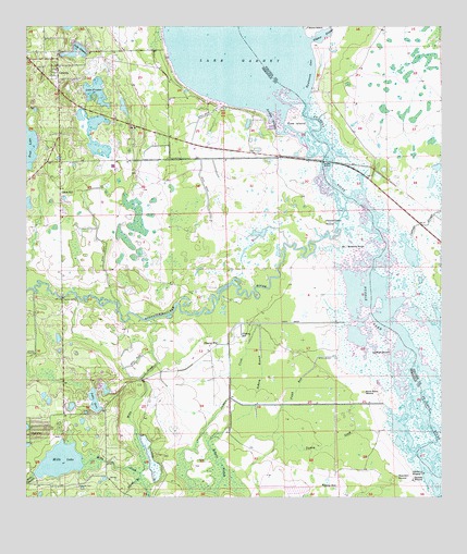
Geneva, FL USGS Topographic Map
Click on map above to begin viewing in our Map Viewer.

This topographic map contains these locations and features:
Feature Name Type Latitude Longitude GNIS ID View Map
Big Oaks Ranch AirportAirportN28.6667°W81.0854°309326View Map
Big RunStreamN28.7289°W81.0667°305009View Map
Buck LakeLakeN28.7178°W81.1250°279581View Map
Buck Point MoundSummitN28.6531°W81.0231°279585View Map
BudaPopulated PlaceN28.7139°W81.1112°301361View Map
Buzzard RoostSummitN28.6917°W81.0289°279771View Map
ChuluotaPopulated PlaceN28.6419°W81.1234°277631View Map
Chuluota CemeteryCemeteryN28.6280°W81.1095°280443View Map
Chuluota Census Designated PlaceCensusN28.6380°W81.1159°2402773View Map
Cow IslandIslandN28.7250°W81.0437°280931View Map
Econlockhatchee RiverStreamN28.7042°W81.0281°294000View Map
First Baptist Church of GenevaChurchN28.7392°W81.1151°299462View Map
Fort Lane (historical)MilitaryN28.7333°W81.1000°307416View Map
Futch RunStreamN28.6625°W81.0320°282862View Map
GenevaPopulated PlaceN28.7397°W81.1151°283012View Map
Geneva CemeteryCemeteryN28.7365°W81.1080°283014View Map
Geneva Census Designated PlaceCensusN28.7377°W81.1143°2402520View Map
Geneva Elementary SchoolSchoolN28.7388°W81.1142°299220View Map
Geneva Post OfficePost OfficeN28.7368°W81.1168°2480347View Map
Heiffer MoundSummitN28.6317°W81.0059°283859View Map
Jackson CreekStreamN28.6706°W81.0545°284676View Map
Jordan SloughBayN28.7252°W81.0507°284935View Map
Lake GenevaLakeN28.7441°W81.1087°283016View Map
Lake GoreLakeN28.6506°W81.1044°283228View Map
Lake ProctorLakeN28.7331°W81.1038°304998View Map
Little RunStreamN28.7314°W81.0695°305008View Map
Long LakeLakeN28.7245°W81.1040°305012View Map
Mill LakeLakeN28.6347°W81.1146°286888View Map
Mills BranchStreamN28.6314°W81.1220°286933View Map
Mills CreekStreamN28.6725°W81.0867°286935View Map
Moccasin MoundSummitN28.6306°W81.0137°287038View Map
Moran LakeLakeN28.7264°W81.1086°305010View Map
Noah MoundSummitN28.6636°W81.0198°287748View Map
Palmer-Taylor MoundSummitN28.6981°W81.0348°288427View Map
Puzzle LakeLakeN28.6647°W81.0137°289390View Map
Raulerson CoveBayN28.7377°W81.0386°289508View Map
Roberts BranchStreamN28.6711°W81.0539°289777View Map
Saddle MoundSummitN28.6297°W81.0084°290117View Map
Seminole County Fire Department Fire Station 42BuildingN28.7384°W81.1201°2331281View Map
Silcox BranchStreamN28.6308°W81.0909°291105View Map
Snow HillPopulated PlaceN28.7033°W81.1145°291310View Map
Southerland StripAirportN28.7335°W81.0826°309459View Map
Still LakeLakeN28.7291°W81.0957°305011View Map
Taylor LakeLakeN28.7178°W81.1028°305007View Map
Turkey CreekStreamN28.6433°W81.0162°292510View Map
Volusia County Fire Services Station 37 HarneyBuildingN28.7306°W81.0327°2331224View Map

Note: Coordinates in the location and feature list above are referenced to NAD83 datum.


Copyright (C) 2008-2025 Ryan Niemi / Sunset Dynamics ... All Rights Reserved