TopoQuest Logo
Do you find TopoQuest useful?
Help keep TopoQuest running and adding new maps/features by donating!
Bitcoin:  19c7KJd3qBynnjoSw5npx9KScwjBe4ifkT
Litecoin:  LXs6TkuXGGXo1vDsWCkWVdjQX94eUKd6ui
Home View Maps Find Maps Find Places Resources & Links


Seton Village, New Mexico Topographic Map

USGS Map Title: Seton Village, NM
USGS Map MRC: 35105E8
DRG (GeoTIFF) Download: o35105e8.tif


Neighboring USGS Topographic Map Quads:


  Agua Fria, NM  
35106F1
 

  Santa Fe, NM  
35105F8
 

  McClure Reservoir, NM  
35105F7
 

  Turquoise Hill, NM  
35106E1
 

  Seton Village, NM  
35105E8
 

  Glorieta, NM  
35105E7
 

  Picture Rock, NM  
35106D1
 

  Galisteo, NM  
35105D8
 

  Bull Canyon, NM  
35105D7


Map MRC Location:

N36°
W106°
N36°
W105°
H8 H7 H6 H5 H4 H3 H2 H1
G8 G7 G6 G5 G4 G3 G2 G1
F8 F7 F6 F5 F4 F3 F2 F1
E8 E7 E6 E5 E4 E3 E2 E1
D8 D7 D6 D5 D4 D3 D2 D1
C8 C7 C6 C5 C4 C3 C2 C1
B8 B7 B6 B5 B4 B3 B2 B1
A8 A7 A6 A5 A4 A3 A2 A1
N35°
W106°
N35°
W105°

Seton Village, NM USGS 1:24K Topographic Map Preview:
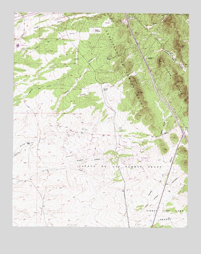
Seton Village, NM USGS Topographic Map
Click on map above to begin viewing in our Map Viewer.

This topographic map contains these locations and features:
Feature Name Type Latitude Longitude GNIS ID View Map
10229 Water WellWellN35.6153°W105.8956°925571View Map
10231 Water WellWellN35.5539°W105.8761°926844View Map
10259 Water WellWellN35.5520°W105.9725°926842View Map
Camp StonyLocaleN35.5678°W105.9584°924789View Map
Caņada AnchaValleyN35.5642°W105.9717°918100View Map
Caņada de las MinasValleyN35.5642°W105.9717°918093View Map
Caņada De Los Alamos GrantCivilN35.5284°W105.9317°904448View Map
Canyon AnchoValleyN35.5523°W105.8970°918123View Map
Cerros NegrosRidgeN35.5861°W105.8818°918153View Map
El DoradoPopulated PlaceN35.5417°W105.9172°916021View Map
El Dorado at Santa FePopulated PlaceN35.5486°W105.9089°914000View Map
El Dorado Elementary SchoolSchoolN35.5389°W105.9092°916020View Map
El Rancho MontosoLocaleN35.5986°W105.9042°906081View Map
Eldorado at Santa FePopulated PlaceN35.5264°W105.9347°1867384View Map
Eldorado at Santa FeLocaleN35.5439°W105.9364°927263View Map
Eldorado at Santa Fe Census Designated PlaceCensusN35.5273°W105.9340°2408070View Map
Gallina CampLocaleN35.5486°W105.9881°906446View Map
Health centers of Northern New Mex La Loma ClinicHospitalN35.6195°W105.9306°901311View Map
La LomaPopulated PlaceN35.6195°W105.9306°918221View Map
La Loma Post OfficePost OfficeN35.6195°W105.9284°938537View Map
Low Vicnty Water WellWellN35.5270°W105.9886°926841View Map
Lower Vicinity WellWellN35.5273°W105.9886°908295View Map
Monte Vista Montessori SchoolSchoolN35.5423°W105.9150°916042View Map
Ninemile RanchLocaleN35.5811°W105.9361°909090View Map
Piedras Negras CanyonValleyN35.6036°W105.8939°909630View Map
Pueblo WellWellN35.5550°W105.8928°909882View Map
Rancho La MercedLocaleN35.6145°W105.9434°910002View Map
RG-14644 Water WellWellN35.6150°W105.9792°925572View Map
RG-17862 Water WellWellN35.6173°W105.9689°925573View Map
RG-18332 Water WellWellN35.6206°W105.9706°922604View Map
RG-18512 Water WellWellN35.5495°W105.9650°922618View Map
RG-18513 Water WellWellN35.5348°W105.9631°922614View Map
RG-18529 Water WellWellN35.5536°W105.9447°926843View Map
RG-18537 Water WellWellN35.5542°W105.9486°926845View Map
RG-18559 Water WellWellN35.5495°W105.9650°922619View Map
RG-18572 Water WellWellN35.5348°W105.9631°925911View Map
RG-18584 Water WellWellN35.5023°W105.9303°922625View Map
RG-18585 Water WellWellN35.5050°W105.9389°926836View Map
RG-18593 Water WellWellN35.5261°W105.9609°926839View Map
RG-18594 Water WellWellN35.5261°W105.9609°926840View Map
RG-19632 Water WellWellN35.6228°W105.9653°922605View Map
RG-23448 Water WellWellN35.6181°W105.9664°922602View Map
RG-25679 Water WellWellN35.5945°W105.9820°925570View Map
RG-28307 Water WellWellN35.5164°W105.9525°926838View Map
RG-8247 Water WellWellN35.5742°W105.9525°922613View Map
Santa Fe Community CollegeSchoolN35.6059°W105.9964°916065View Map
Santa Fe CountyCivilN35.5065°W105.9765°933322View Map
Santa Fe County Volunteer Fire Department Hondo District Station 1BuildingN35.6062°W105.9165°2658021View Map
Santa Fe County Volunteer Fire El Dorado District Station 1BuildingN35.5397°W105.9121°2657765View Map
Santa Fe County Volunteer Fire El Dorado District Station 2BuildingN35.5394°W105.9643°2657956View Map
Santa Fe County Volunteer Fire El Dorado District Station 3BuildingN35.5107°W105.8954°2657849View Map
Santa Fe County Volunteer Fire Hondo District Station 2BuildingN35.5557°W105.8764°2657840View Map
Santa Fe on the Camino RealParkN35.5486°W105.9089°932280View Map
Sebastian de Vargas GrantCivilN35.5920°W105.9200°915901View Map
Seton Castle Historic SiteBuildingN35.5992°W105.9325°934339View Map
Seton VillagePopulated PlaceN35.5992°W105.9325°918360View Map
Seton Village Historical MarkerParkN35.5992°W105.9325°932319View Map
Seton Village National Historic LandmarkLocaleN35.5992°W105.9325°935496View Map
Upper Vicinity WellWellN35.5348°W105.9625°912008View Map

Note: Coordinates in the location and feature list above are referenced to NAD83 datum.


Copyright (C) 2008-2024 Ryan Niemi / Sunset Dynamics ... All Rights Reserved