TopoQuest Logo
Do you find TopoQuest useful?
Help keep TopoQuest running and adding new maps/features by donating!
Bitcoin:  19c7KJd3qBynnjoSw5npx9KScwjBe4ifkT
Litecoin:  LXs6TkuXGGXo1vDsWCkWVdjQX94eUKd6ui
Home View Maps Find Maps Find Places Resources & Links


Seymour, Missouri Topographic Map

USGS Map Title: Seymour, MO
USGS Map MRC: 37092B7
DRG (GeoTIFF) Download: o37092b7.tif


Neighboring USGS Topographic Map Quads:


  Marshfield, MO  
37092C8
 

  High Prairie, MO  
37092C7
 

  Duncan, MO  
37092C6
 

  Fordland, MO  
37092B8
 

  Seymour, MO  
37092B7
 

  Mansfield NW, MO  
37092B6
 

  Bruner, MO  
37092A8
 

  Dogwood, MO  
37092A7
 

  Cedar Gap, MO  
37092A6


Map MRC Location:

N38°
W93°
N38°
W92°
H8 H7 H6 H5 H4 H3 H2 H1
G8 G7 G6 G5 G4 G3 G2 G1
F8 F7 F6 F5 F4 F3 F2 F1
E8 E7 E6 E5 E4 E3 E2 E1
D8 D7 D6 D5 D4 D3 D2 D1
C8 C7 C6 C5 C4 C3 C2 C1
B8 B7 B6 B5 B4 B3 B2 B1
A8 A7 A6 A5 A4 A3 A2 A1
N37°
W93°
N37°
W92°

Seymour, MO USGS 1:24K Topographic Map Preview:
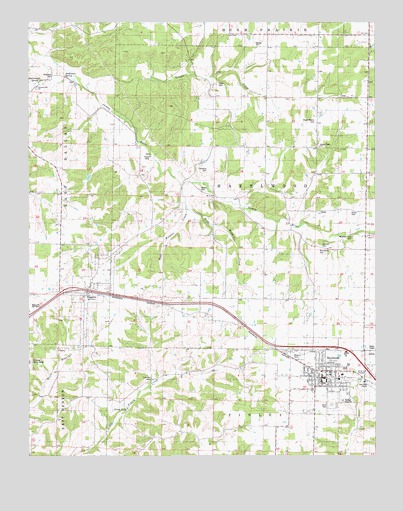
Seymour, MO USGS Topographic Map
Click on map above to begin viewing in our Map Viewer.

This topographic map contains these locations and features:
Feature Name Type Latitude Longitude GNIS ID View Map
Alberta SchoolSchoolN37.2225°W92.7716°713187View Map
Alcorn CemeteryCemeteryN37.1953°W92.7588°742136View Map
Bright Prairie CemeteryCemeteryN37.2212°W92.7718°742134View Map
Bright Prairie SchoolSchoolN37.2142°W92.7702°742135View Map
Burnett SchoolSchoolN37.1320°W92.8191°715079View Map
Childress CemeteryCemeteryN37.2073°W92.8104°715781View Map
City of SeymourCivilN37.1484°W92.7694°2395852View Map
Civil War CemeteryCemeteryN37.1470°W92.8310°742142View Map
DigginsPopulated PlaceN37.1726°W92.8543°716894View Map
Diggins Post OfficePost OfficeN37.1728°W92.8473°2779482View Map
East Wildcat CreekStreamN37.1973°W92.8185°738207View Map
Finley FallsPopulated PlaceN37.1387°W92.8402°740851View Map
Gentry CemeteryCemeteryN37.2017°W92.8132°742133View Map
Gentry SchoolSchoolN37.2023°W92.8216°718389View Map
George CemeteryCemeteryN37.2439°W92.7932°718394View Map
Liberty SchoolSchoolN37.2492°W92.7610°720987View Map
Masonic CemeteryCemeteryN37.1542°W92.7804°742141View Map
McCormack SpringSpringN37.2328°W92.8721°738206View Map
McElwain CemeteryCemeteryN37.2348°W92.8666°742131View Map
McElwain SpringSpringN37.2342°W92.8618°738623View Map
Mountain DalePopulated PlaceN37.1889°W92.7541°734977View Map
Mountain Dale CemeteryCemeteryN37.1878°W92.7582°742137View Map
Mountain Dale SchoolSchoolN37.1876°W92.7532°722988View Map
Pleasant Hill ChurchChurchN37.2323°W92.8580°724525View Map
Porter MineMineN37.2112°W92.8313°742132View Map
SeymourPopulated PlaceN37.1464°W92.7688°735848View Map
Seymour Fire DepartmentBuildingN37.1459°W92.7675°2620913View Map
Seymour Police DepartmentBuildingN37.1460°W92.7693°2752229View Map
Seymour Post OfficePost OfficeN37.1460°W92.7702°2779481View Map
Slack SchoolSchoolN37.2323°W92.8588°726522View Map
South ParkParkN37.1398°W92.7657°742140View Map
Southern Webster County Fire Protection District Station 2BuildingN37.1470°W92.7702°2620935View Map
Southern Webster County Fire Protection District Station 3BuildingN37.1719°W92.8552°2620445View Map
Teague CreekStreamN37.2314°W92.8555°727503View Map
Teague SchoolSchoolN37.2406°W92.8160°727504View Map
Township of DigginsCivilN37.1848°W92.8558°2397792View Map
Trimble CemeteryCemeteryN37.1856°W92.7693°742138View Map
Village of DigginsCivilN37.1740°W92.8504°2398724View Map
West Wildcat CreekStreamN37.1973°W92.8185°738208View Map
Winingham CemeteryCemeteryN37.1848°W92.7702°729001View Map

Note: Coordinates in the location and feature list above are referenced to NAD83 datum.


Copyright (C) 2008-2025 Ryan Niemi / Sunset Dynamics ... All Rights Reserved