TopoQuest Logo
Do you find TopoQuest useful?
Help keep TopoQuest running and adding new maps/features by donating!
Bitcoin:  19c7KJd3qBynnjoSw5npx9KScwjBe4ifkT
Litecoin:  LXs6TkuXGGXo1vDsWCkWVdjQX94eUKd6ui
Home View Maps Find Maps Find Places Resources & Links


Bruner, Missouri Topographic Map

USGS Map Title: Bruner, MO
USGS Map MRC: 37092A8
DRG (GeoTIFF) Download: o37092a8.tif


Neighboring USGS Topographic Map Quads:


  Oak Grove Heights, MO  
37093B1
 

  Fordland, MO  
37092B8
 

  Seymour, MO  
37092B7
 

  Rogersville, MO  
37093A1
 

  Bruner, MO  
37092A8
 

  Dogwood, MO  
37092A7
 

  Chadwick, MO  
36093H1
 

  Keltner, MO  
36092H8
 

  Goodhope, MO  
36092H7


Map MRC Location:

N38°
W93°
N38°
W92°
H8 H7 H6 H5 H4 H3 H2 H1
G8 G7 G6 G5 G4 G3 G2 G1
F8 F7 F6 F5 F4 F3 F2 F1
E8 E7 E6 E5 E4 E3 E2 E1
D8 D7 D6 D5 D4 D3 D2 D1
C8 C7 C6 C5 C4 C3 C2 C1
B8 B7 B6 B5 B4 B3 B2 B1
A8 A7 A6 A5 A4 A3 A2 A1
N37°
W93°
N37°
W92°

Bruner, MO USGS 1:24K Topographic Map Preview:
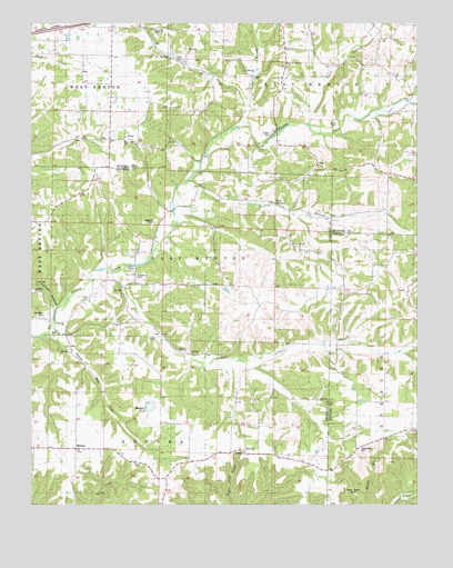
Bruner, MO USGS Topographic Map
Click on map above to begin viewing in our Map Viewer.

This topographic map contains these locations and features:
Feature Name Type Latitude Longitude GNIS ID View Map
AbadylPopulated PlaceN37.0384°W92.9471°740613View Map
BrunerPopulated PlaceN37.0148°W92.9860°714814View Map
Bruner ChurchChurchN37.0109°W92.9668°742156View Map
Bruner Post OfficePost OfficeN37.0147°W92.9862°2779530View Map
Bruner School (historical)SchoolN37.0139°W92.9857°733163View Map
Davis BranchStreamN37.0992°W92.9110°716700View Map
Dillon SchoolSchoolN37.0923°W92.8782°716905View Map
Easter CemeteryCemeteryN37.0964°W92.9224°742162View Map
ElkheadPopulated PlaceN37.0137°W92.9305°740826View Map
Fairview ChurchChurchN37.0867°W92.9085°742163View Map
GertrudeLocaleN37.0542°W92.9971°740305View Map
GlesaLocaleN37.0401°W92.9699°740306View Map
Greasy CreekStreamN37.0991°W92.9317°718772View Map
Green Hill ChapelChurchN37.1237°W92.9605°742160View Map
Green Hill SchoolSchoolN37.1051°W92.9613°718795View Map
Hyde CemeteryCemeteryN37.0431°W92.9618°720057View Map
Johns Mills (historical)Populated PlaceN37.0362°W92.8907°733854View Map
La Rose ChurchChurchN37.0467°W92.9721°743397View Map
La Rose SchoolSchoolN37.0467°W92.9721°720716View Map
Little Finley CreekStreamN37.1045°W92.8768°721231View Map
Martins BranchStreamN37.0839°W92.9496°721938View Map
MathalLocaleN37.1242°W92.9885°740307View Map
McHaffie CemeteryCemeteryN37.0492°W92.9963°742157View Map
McHaffie ChurchChurchN37.0556°W92.9991°743398View Map
McHaffie SchoolSchoolN37.0556°W92.9991°722125View Map
Mount Gillian ChurchChurchN37.1148°W92.9174°742161View Map
Murphy PondLakeN37.0254°W92.9618°723076View Map
OlgaPopulated PlaceN37.0887°W92.9068°723801View Map
Ozarks Flying Patch Airport (historical)AirportN37.0014°W92.9405°758945View Map
Pauls Lake DamDamN37.0567°W92.9368°763316View Map
Phillips HollowValleyN37.0512°W92.9921°724296View Map
Pleasant Hope School (historical)SchoolN37.0256°W92.8780°724565View Map
Ragsdale CemeteryCemeteryN37.0734°W92.9613°725064View Map
Roberts SchoolSchoolN37.0570°W92.9305°741628View Map
Rogers SchoolSchoolN37.0573°W92.9305°725535View Map
Sartin CemeteryCemeteryN37.0987°W92.9013°742164View Map
Sherrow SchoolSchoolN37.0784°W92.9296°726340View Map
Silver Shade School (historical)SchoolN37.1181°W92.9205°726457View Map
Southern Webster County Fire Protection District Station 4BuildingN37.0884°W92.8923°2621292View Map
Squaw Run CreekStreamN37.0431°W92.9935°726979View Map
Stewart CreekStreamN37.0609°W92.9746°735869View Map
Swearengin CemeteryCemeteryN37.0150°W92.8924°742155View Map
Temple Hill CemeteryCemeteryN37.0592°W92.9666°742158View Map
Temple Hill Church (historical)ChurchN37.0598°W92.9668°727522View Map
Terell BranchStreamN37.1031°W92.9305°727535View Map
Todd SpringSpringN37.0784°W92.9216°727694View Map
Township of BrunerCivilN37.0079°W92.9618°766472View Map
Township of East BentonCivilN37.0644°W92.9491°766474View Map
Township of Green HillCivilN37.1139°W92.9216°2397807View Map
Township of SpencerCivilN37.0044°W92.8773°766630View Map
Union ChapelChurchN37.0689°W92.9163°727972View Map
West Finley CemeteryCemeteryN37.0944°W92.9707°2703094View Map
West Finley ChurchChurchN37.0945°W92.9699°742159View Map
ZenarPopulated PlaceN37.0951°W92.9705°741380View Map

Note: Coordinates in the location and feature list above are referenced to NAD83 datum.


Copyright (C) 2008-2025 Ryan Niemi / Sunset Dynamics ... All Rights Reserved