TopoQuest Logo
Do you find TopoQuest useful?
Help keep TopoQuest running and adding new maps/features by donating!
Bitcoin:  19c7KJd3qBynnjoSw5npx9KScwjBe4ifkT
Litecoin:  LXs6TkuXGGXo1vDsWCkWVdjQX94eUKd6ui
Home View Maps Find Maps Find Places Resources & Links


Shaw, Mississippi Topographic Map

USGS Map Title: Shaw, MS
USGS Map MRC: 33090E7
DRG (GeoTIFF) Download: o33090e7.tif


Neighboring USGS Topographic Map Quads:


  Lobdell, MS  
33090F8
 

  Skene, MS  
33090F7
 

  Cleveland, MS  
33090F6
 

  Stringtown, MS  
33090E8
 

  Shaw, MS  
33090E7
 

  Boyer, MS  
33090E6
 

  Leland, MS  
33090D8
 

  Holly Ridge, MS  
33090D7
 

  Indianola, MS  
33090D6


Map MRC Location:

N34°
W91°
N34°
W90°
H8 H7 H6 H5 H4 H3 H2 H1
G8 G7 G6 G5 G4 G3 G2 G1
F8 F7 F6 F5 F4 F3 F2 F1
E8 E7 E6 E5 E4 E3 E2 E1
D8 D7 D6 D5 D4 D3 D2 D1
C8 C7 C6 C5 C4 C3 C2 C1
B8 B7 B6 B5 B4 B3 B2 B1
A8 A7 A6 A5 A4 A3 A2 A1
N33°
W91°
N33°
W90°

Shaw, MS USGS 1:24K Topographic Map Preview:
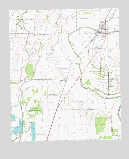
Shaw, MS USGS Topographic Map
Click on map above to begin viewing in our Map Viewer.

This topographic map contains these locations and features:
Feature Name Type Latitude Longitude GNIS ID View Map
Antioch ChurchChurchN33.6218°W90.7979°666323View Map
Bethlehem Number 1 ChurchChurchN33.5654°W90.7951°667028View Map
Bethlehem Number 2 ChurchChurchN33.5729°W90.7965°667029View Map
Bogue HastyStreamN33.5571°W90.8584°667391View Map
Bolivar County Volunteer Fire Department District 5 Station 1 ShawBuildingN33.6010°W90.7727°2665631View Map
BuseyPopulated PlaceN33.5587°W90.8634°691739View Map
ChoctawPopulated PlaceN33.5579°W90.8132°668406View Map
City of ShawCivilN33.6015°W90.7720°2405451View Map
Clear CreekStreamN33.5057°W90.8654°668567View Map
Cold Water BayouStreamN33.5084°W90.8623°668662View Map
Ditch Number EightCanalN33.5371°W90.8265°690118View Map
Ditch Number FiveCanalN33.6237°W90.7801°690119View Map
Ditch Number Five ACanalN33.6207°W90.7693°690120View Map
Ditch Number NineCanalN33.5432°W90.8504°690122View Map
Ditch Number Nine ACanalN33.5315°W90.8487°690123View Map
Dowd Plantation (historical)LocaleN33.5598°W90.8140°711038View Map
Fairview ChurchChurchN33.5187°W90.7506°669888View Map
Greengrove ChurchChurchN33.6018°W90.8079°670692View Map
Harris Ranch Catfish Pond DamDamN33.5018°W90.8518°682148View Map
HelmPopulated PlaceN33.5009°W90.8345°671093View Map
Helm CemeteryCemeteryN33.5001°W90.8326°671094View Map
Lees FlatLocaleN33.6029°W90.8570°690117View Map
McEvans SchoolSchoolN33.5987°W90.7709°711039View Map
Mexican CemeteryCemeteryN33.6162°W90.8501°673512View Map
Mount Galilee ChurchChurchN33.5182°W90.8545°673997View Map
NapaneePopulated PlaceN33.5062°W90.8709°692096View Map
New Whitestone Church (historical)ChurchN33.5029°W90.8329°690116View Map
Pauls Church (historical)ChurchN33.5248°W90.7543°690114View Map
Pecan Bayou CutoffGutN33.6165°W90.8182°675562View Map
Pilgrims Rest ChurchChurchN33.6015°W90.8462°675777View Map
ShawPopulated PlaceN33.6018°W90.7737°677626View Map
Shaw High SchoolSchoolN33.6107°W90.7668°711040View Map
Shaw Police DepartmentBuildingN33.6000°W90.7760°2754193View Map
Shaw Post OfficePost OfficeN33.6017°W90.7719°2768817View Map
Shaw Sewage Lagoon DamDamN33.5884°W90.7734°682221View Map
Silver BayouStreamN33.6032°W90.7545°677788View Map
Strangers Rest CemeteryCemeteryN33.6123°W90.7665°678341View Map
Tapley AirportAirportN33.6011°W90.7777°2676430View Map
Turners FlatPopulated PlaceN33.6234°W90.8543°690124View Map

Note: Coordinates in the location and feature list above are referenced to NAD83 datum.


Copyright (C) 2008-2025 Ryan Niemi / Sunset Dynamics ... All Rights Reserved