TopoQuest Logo
Do you find TopoQuest useful?
Help keep TopoQuest running and adding new maps/features by donating!
Bitcoin:  19c7KJd3qBynnjoSw5npx9KScwjBe4ifkT
Litecoin:  LXs6TkuXGGXo1vDsWCkWVdjQX94eUKd6ui
Home View Maps Find Maps Find Places Resources & Links


Shelly Creek Ridge, California Topographic Map

USGS Map Title: Shelly Creek Ridge, CA
USGS Map MRC: 41123H7
DRG (GeoTIFF) Download: o41123h7.tif


Neighboring USGS Topographic Map Quads:


  Biscuit Hill, OR  
42123A8
 

  Buckskin Peak, OR  
42123A7
 

  O'Brien, OR  
42123A6
 

  High Plateau Mountain, CA  
41123H8
 

  Shelly Creek Ridge, CA  
41123H7
 

  Broken Rib Mountain, CA  
41123H6
 

  Gasquet, CA  
41123G8
 

  Hurdygurdy Butte, CA  
41123G7
 

  Devils Punchbowl, CA  
41123G6


Map MRC Location:

N42°
W124°
N42°
W123°
H8 H7 H6 H5 H4 H3 H2 H1
G8 G7 G6 G5 G4 G3 G2 G1
F8 F7 F6 F5 F4 F3 F2 F1
E8 E7 E6 E5 E4 E3 E2 E1
D8 D7 D6 D5 D4 D3 D2 D1
C8 C7 C6 C5 C4 C3 C2 C1
B8 B7 B6 B5 B4 B3 B2 B1
A8 A7 A6 A5 A4 A3 A2 A1
N41°
W124°
N41°
W123°

Shelly Creek Ridge, CA USGS 1:24K Topographic Map Preview:
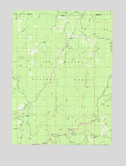
Shelly Creek Ridge, CA USGS Topographic Map
Click on map above to begin viewing in our Map Viewer.

This topographic map contains these locations and features:
Feature Name Type Latitude Longitude GNIS ID View Map
Baker FlatFlatN41.9682°W123.8079°218544View Map
Blue Rock MineMineN41.9618°W123.8020°1683089View Map
Boulder CreekStreamN41.8998°W123.8679°219691View Map
Cedar Rustic CampgroundLocaleN41.8771°W123.8309°277175View Map
Cedar TroughSpringN41.9696°W123.8345°1657316View Map
Cedar Trough CampLocaleN41.9726°W123.8315°274778View Map
Cedar Trough Camp GroundLocaleN41.9721°W123.8337°220801View Map
Continental MineMineN41.9790°W123.8037°1683093View Map
Dead Horse GulchValleyN41.8826°W123.8295°222100View Map
Dollar BendBendN41.8834°W123.8259°222474View Map
East Fork Patrick CreekStreamN41.9151°W123.8565°222892View Map
Elevenmile CreekStreamN41.9001°W123.8576°223092View Map
Griffin CreekStreamN41.9204°W123.7642°224615View Map
High DomeSummitN41.9454°W123.8540°225264View Map
Holiday MineMineN41.9473°W123.8684°225446View Map
Horse FlatFlatN41.9046°W123.7695°1682276View Map
IdlewildPopulated PlaceN41.8984°W123.7720°1658781View Map
Idlewild CreekStreamN41.8973°W123.7712°252339View Map
Idlewild ResortLocaleN41.8990°W123.7712°1682415View Map
Logan MineMineN41.9554°W123.8656°1683104View Map
Monkey CreekStreamN41.8832°W123.8209°228919View Map
Monkey Creek Lookout (historical)LocaleN41.9287°W123.7826°1682421View Map
Monkey Creek RidgeRidgeN41.9468°W123.7817°228920View Map
MonumentalLocaleN41.9746°W123.8051°228996View Map
Old Patrick Creek StationLocaleN41.9123°W123.8570°1652889View Map
Old Patrick Creek Station (historical)LocaleN41.9148°W123.8554°1682280View Map
Packsaddle CreekStreamN41.9107°W123.7676°230224View Map
Patrick CreekPopulated PlaceN41.8751°W123.8451°1657337View Map
Patrick Creek Tavern (historical)BuildingN41.8751°W123.8431°1682422View Map
Richey MineMineN41.9804°W123.8540°1683109View Map
Shelly CreekStreamN41.9007°W123.8554°232941View Map
Shelly Creek CampgroundLocaleN41.9007°W123.8554°232942View Map
Shelly Creek RidgeRidgeN41.9112°W123.8217°232943View Map
Siskiyou ForkStreamN41.8840°W123.8109°233180View Map
Stephens CreekStreamN41.8971°W123.7645°252341View Map
Tenmile CreekStreamN41.9071°W123.8579°236106View Map
Twelvemile CreekStreamN41.8876°W123.8551°236677View Map
Washington FlatFlatN41.8873°W123.7998°237274View Map
Washington PeakSummitN41.8823°W123.7734°237289View Map
Washington RanchLocaleN41.8873°W123.8042°1682348View Map
West Fork Patrick CreekStreamN41.9151°W123.8562°237479View Map

Note: Coordinates in the location and feature list above are referenced to NAD83 datum.


Copyright (C) 2008-2025 Ryan Niemi / Sunset Dynamics ... All Rights Reserved