TopoQuest Logo
Do you find TopoQuest useful?
Help keep TopoQuest running and adding new maps/features by donating!
Bitcoin:  19c7KJd3qBynnjoSw5npx9KScwjBe4ifkT
Litecoin:  LXs6TkuXGGXo1vDsWCkWVdjQX94eUKd6ui
Home View Maps Find Maps Find Places Resources & Links


Shickshinny, Pennsylvania Topographic Map

USGS Map Title: Shickshinny, PA
USGS Map MRC: 41076B2
DRG (GeoTIFF) Download: o41076b2.tif


Neighboring USGS Topographic Map Quads:


  Red Rock, PA  
41076C3
 

  Sweet Valley, PA  
41076C2
 

  Harveys Lake, PA  
41076C1
 

  Stillwater, PA  
41076B3
 

  Shickshinny, PA  
41076B2
 

  Nanticoke, PA  
41076B1
 

  Mifflinville, PA  
41076A3
 

  Berwick, PA  
41076A2
 

  Sybertsville, PA  
41076A1


Map MRC Location:

N42°
W77°
N42°
W76°
H8 H7 H6 H5 H4 H3 H2 H1
G8 G7 G6 G5 G4 G3 G2 G1
F8 F7 F6 F5 F4 F3 F2 F1
E8 E7 E6 E5 E4 E3 E2 E1
D8 D7 D6 D5 D4 D3 D2 D1
C8 C7 C6 C5 C4 C3 C2 C1
B8 B7 B6 B5 B4 B3 B2 B1
A8 A7 A6 A5 A4 A3 A2 A1
N41°
W77°
N41°
W76°

Shickshinny, PA USGS 1:24K Topographic Map Preview:
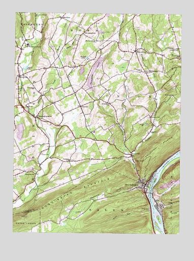
Shickshinny, PA USGS Topographic Map
Click on map above to begin viewing in our Map Viewer.

This topographic map contains these locations and features:
Feature Name Type Latitude Longitude GNIS ID View Map
Bellis IslandIslandN41.1554°W76.1427°1169178View Map
Black Ash CreekStreamN41.2226°W76.2138°1169687View Map
Black CreekStreamN41.1451°W76.1452°1169696View Map
BloomingdalePopulated PlaceN41.2384°W76.1985°1203120View Map
Bloomingdale ChurchChurchN41.2345°W76.1883°1169854View Map
Borough of ShickshinnyCivilN41.1534°W76.1500°1215408View Map
BroadwayPopulated PlaceN41.2473°W76.2147°1170300View Map
Clear Brook LodgeBuildingN41.1268°W76.2263°2718008View Map
Culver CreekStreamN41.2254°W76.1830°1172822View Map
DogtownPopulated PlaceN41.1392°W76.1463°1173349View Map
Harmony ChurchChurchN41.2037°W76.1299°1176551View Map
HarveyvillePopulated PlaceN41.2140°W76.2460°1203757View Map
Hidden LakeReservoirN41.2172°W76.1993°1195360View Map
Hidden Lake DamDamN41.2151°W76.1980°1195359View Map
Hiland LakeReservoirN41.2246°W76.1955°1177063View Map
Hillcrest LakeReservoirN41.1776°W76.1749°1212399View Map
Huntington MillsPopulated PlaceN41.1906°W76.2335°1177628View Map
Huntington Mills Paper Mill DamDamN41.1967°W76.2430°1195338View Map
Huntington Mills Post OfficePost OfficeN41.1907°W76.2327°2773162View Map
Huntington MountainSummitN41.1387°W76.2283°1177629View Map
Huntington Valley Volunteer Fire Company and Ambulance AssociationBuildingN41.1891°W76.2292°2653448View Map
Jeans Run Golf CourseLocaleN41.2315°W76.1672°1205623View Map
Kitchen CreekStreamN41.2295°W76.2358°1192714View Map
Koons DamLocaleN41.1965°W76.2413°1178645View Map
KoonsvillePopulated PlaceN41.1692°W76.1608°1178647View Map
Lake PinecrestReservoirN41.1822°W76.2449°1195327View Map
Lake Pinecrest DamDamN41.1834°W76.2447°1195326View Map
Little IslandIslandN41.1334°W76.1394°1179568View Map
Little Shickshinny CreekStreamN41.1540°W76.1549°1179680View Map
Lower Muhlenburg ChurchChurchN41.2173°W76.1522°1180025View Map
Marsh CreekStreamN41.2226°W76.2141°1180447View Map
Marshall HollowValleyN41.2210°W76.2470°1180470View Map
Marvin CemeteryCemeteryN41.2179°W76.1544°1180509View Map
McKendree SchoolSchoolN41.1992°W76.1783°1180749View Map
MocanaquaPopulated PlaceN41.1412°W76.1388°1181387View Map
Mocanaqua Census Designated PlaceCensusN41.1406°W76.1368°2630027View Map
Mocanaqua Volunteer Fire Company Station 118BuildingN41.1432°W76.1418°2652658View Map
MuhlenburgPopulated PlaceN41.2290°W76.1591°1182069View Map
Nevel HollowValleyN41.2342°W76.1746°1182274View Map
Osborn Culver PondLakeN41.2398°W76.1857°1183062View Map
Paddy RunStreamN41.1467°W76.1474°1202476View Map
Paper Mill PondReservoirN41.1967°W76.2430°1195337View Map
Patterson GrovePopulated PlaceN41.2317°W76.2399°1183370View Map
Pine Grove CemeteryCemeteryN41.2070°W76.2341°1183799View Map
Pleasant ValleyPopulated PlaceN41.2406°W76.2355°1212395View Map
Pleasant Valley SchoolSchoolN41.2481°W76.2349°1184080View Map
ReyburnLocaleN41.1926°W76.1474°1212398View Map
Reyburn CreekStreamN41.1695°W76.1602°1184964View Map
Reyburn SchoolSchoolN41.1917°W76.1463°1184966View Map
Rocky RunStreamN41.1370°W76.1583°1185367View Map
Rogers CreekStreamN41.1917°W76.2360°1185391View Map
Salem CollieryBuildingN41.1465°W76.1497°1207182View Map
Scott CemeteryCemeteryN41.1701°W76.2283°1187160View Map
Searchs IslandIslandN41.1695°W76.1255°1202513View Map
ShickshinnyPopulated PlaceN41.1531°W76.1502°1187506View Map
Shickshinny CreekStreamN41.1515°W76.1469°1187507View Map
Shickshinny Fire TowerTowerN41.1667°W76.1519°1212400View Map
Shickshinny LakeReservoirN41.2196°W76.1887°1200570View Map
Shickshinny Lake DamDamN41.2051°W76.1913°1195348View Map
Shickshinny MountainSummitN41.1756°W76.1391°1187508View Map
Shickshinny Post OfficePost OfficeN41.1538°W76.1478°2768366View Map
Shickshinny Volunteer Fire CompanyBuildingN41.1539°W76.1515°2653083View Map
Silver LakeLakeN41.2184°W76.2416°1187680View Map
Sorber CemeteryCemeteryN41.1829°W76.1469°1188001View Map
Sorber PondLakeN41.1873°W76.1511°1188002View Map
State Game Lands Number 260ParkN41.1334°W76.1997°1208335View Map
SunshineLocaleN41.1656°W76.2077°1212396View Map
Sunshine SchoolSchoolN41.1659°W76.2077°1189099View Map
Sutliff Private Airport (historical)AirportN41.1678°W76.2492°1194184View Map
Town LineLocaleN41.1970°W76.1999°1189689View Map
Township of HuntingtonCivilN41.1828°W76.2445°1216719View Map
Township of UnionCivilN41.1993°W76.1589°1216735View Map
Turtle CreekStreamN41.1423°W76.1444°1189974View Map
Van Horn SchoolSchoolN41.2301°W76.1269°1193594View Map
WatertonLocaleN41.1576°W76.2330°1212397View Map
Waterton SchoolSchoolN41.1584°W76.2327°1190683View Map
West End Number 1 CollieryBuildingN41.1456°W76.1438°1207183View Map

Note: Coordinates in the location and feature list above are referenced to NAD83 datum.


Copyright (C) 2008-2025 Ryan Niemi / Sunset Dynamics ... All Rights Reserved