TopoQuest Logo
Do you find TopoQuest useful?
Help keep TopoQuest running and adding new maps/features by donating!
Bitcoin:  19c7KJd3qBynnjoSw5npx9KScwjBe4ifkT
Litecoin:  LXs6TkuXGGXo1vDsWCkWVdjQX94eUKd6ui
Home View Maps Find Maps Find Places Resources & Links


Shuford, Mississippi Topographic Map

USGS Map Title: Shuford, MS
USGS Map MRC: 34089B7
DRG (GeoTIFF) Download: o34089b7.tif


Neighboring USGS Topographic Map Quads:


  Batesville, MS  
34089C8
 

  Sardis SE, MS  
34089C7
 

  Splinter, MS  
34089C6
 

  Courtland, MS  
34089B8
 

  Shuford, MS  
34089B7
 

  Water Valley West, MS  
34089B6
 

  Oakland, MS  
34089A8
 

  Coker Lake, MS  
34089A7
 

  Velma, MS  
34089A6


Map MRC Location:

N35°
W90°
N35°
W89°
H8 H7 H6 H5 H4 H3 H2 H1
G8 G7 G6 G5 G4 G3 G2 G1
F8 F7 F6 F5 F4 F3 F2 F1
E8 E7 E6 E5 E4 E3 E2 E1
D8 D7 D6 D5 D4 D3 D2 D1
C8 C7 C6 C5 C4 C3 C2 C1
B8 B7 B6 B5 B4 B3 B2 B1
A8 A7 A6 A5 A4 A3 A2 A1
N34°
W90°
N34°
W89°

Shuford, MS USGS 1:24K Topographic Map Preview:
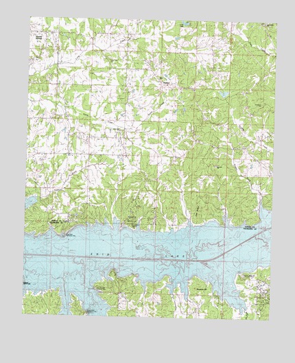
Shuford, MS USGS Topographic Map
Click on map above to begin viewing in our Map Viewer.

This topographic map contains these locations and features:
Feature Name Type Latitude Longitude GNIS ID View Map
Albert Barnett Pond DamDamN34.2184°W89.7818°682510View Map
Basin ChapelChurchN34.1423°W89.7520°666557View Map
Billys CreekStreamN34.1479°W89.7829°692617View Map
Bynum Fire Department District 9 Station 1BuildingN34.2086°W89.7856°2665982View Map
Bynum Fire Department District 9 Station 2BuildingN34.2428°W89.8651°2665983View Map
Bynum Fire Department District 9 Station 3BuildingN34.1654°W89.8528°2665897View Map
Bynums Creek (historical)LocaleN34.2115°W89.7615°685647View Map
Chickasaw HillSummitN34.1684°W89.8218°668385View Map
Chickasaw Hill Recreation AreaParkN34.1640°W89.8223°685652View Map
Dew CreekStreamN34.1404°W89.8551°693088View Map
Elliotts Mills (historical)LocaleN34.2446°W89.8095°685667View Map
Enid LakeReservoirN34.1535°W89.8051°691643View Map
Eureka SpringsPopulated PlaceN34.2437°W89.8645°669826View Map
Eureka Springs Methodist ChurchChurchN34.2407°W89.8662°707415View Map
Hubbard CemeteryCemeteryN34.1629°W89.8204°671543View Map
Jones CreekStreamN34.1401°W89.8745°693639View Map
Kenny CreekStreamN34.2046°W89.8251°672106View Map
LakesidePopulated PlaceN34.1612°W89.8087°691995View Map
Liberty Hill CemeteryCemeteryN34.2023°W89.8276°672463View Map
Liberty Hill ChurchChurchN34.2032°W89.8281°672467View Map
Lone LakeReservoirN34.2489°W89.7963°672780View Map
Long BranchPopulated PlaceN34.1348°W89.8468°692016View Map
Long BranchStreamN34.1426°W89.8437°693821View Map
Long Branch Recreation AreaParkN34.1265°W89.8437°683342View Map
Long Creek CemeteryCemeteryN34.2337°W89.8340°672821View Map
Long Creek ChurchChurchN34.2337°W89.8337°672823View Map
Long Creek Watershed Y-11a-23 DamDamN34.2001°W89.8584°682500View Map
Long Creek Watershed Y-11a-24 DamDamN34.2368°W89.8034°682531View Map
Long Creek Watershed Y-11a-6 DamDamN34.2251°W89.8051°682520View Map
Love Joy CemeteryCemeteryN34.1890°W89.7787°672902View Map
Love Joy ChurchChurchN34.1890°W89.7787°672903View Map
McGees (historical)LocaleN34.1426°W89.8373°705927View Map
Mooney CreekStreamN34.1601°W89.7579°673769View Map
Oak RidgeRidgeN34.1679°W89.7873°675090View Map
Old Bynum CemeteryCemeteryN34.2154°W89.7562°675165View Map
Oliver Ray ChurchChurchN34.1726°W89.8443°675284View Map
Oliver Ray SchoolSchoolN34.1732°W89.8448°675285View Map
Pilgrim Rest CemeteryCemeteryN34.2490°W89.7554°675741View Map
Pilgrims Rest ChurchChurchN34.2490°W89.7556°675781View Map
Pisgah CemeteryCemeteryN34.2248°W89.8087°675935View Map
Pisgah ChurchChurchN34.2248°W89.8087°675941View Map
Plum PointCapeN34.1612°W89.8529°676152View Map
Plum Point Recreation AreaParkN34.1612°W89.8556°683345View Map
Point PleasantCapeN34.1432°W89.8373°676169View Map
Point Pleasant Recreation AreaParkN34.1376°W89.8348°683346View Map
Reynolds (historical)LocaleN34.2412°W89.7562°692354View Map
Rowsey CreekStreamN34.1629°W89.7531°676938View Map
ShufordPopulated PlaceN34.2223°W89.8070°677759View Map
Spyglass HillSummitN34.1379°W89.7879°678193View Map
Water Valley LandingPopulated PlaceN34.1493°W89.7734°692308View Map
Water Valley Landing Recreation AreaParkN34.1432°W89.7640°683350View Map

Note: Coordinates in the location and feature list above are referenced to NAD83 datum.


Copyright (C) 2008-2024 Ryan Niemi / Sunset Dynamics ... All Rights Reserved