TopoQuest Logo
Do you find TopoQuest useful?
Help keep TopoQuest running and adding new maps/features by donating!
Bitcoin:  19c7KJd3qBynnjoSw5npx9KScwjBe4ifkT
Litecoin:  LXs6TkuXGGXo1vDsWCkWVdjQX94eUKd6ui
Home View Maps Find Maps Find Places Resources & Links


Coker Lake, Mississippi Topographic Map

USGS Map Title: Coker Lake, MS
USGS Map MRC: 34089A7
DRG (GeoTIFF) Download: o34089a7.tif


Neighboring USGS Topographic Map Quads:


  Courtland, MS  
34089B8
 

  Shuford, MS  
34089B7
 

  Water Valley West, MS  
34089B6
 

  Oakland, MS  
34089A8
 

  Coker Lake, MS  
34089A7
 

  Velma, MS  
34089A6
 

  Tillatoba, MS  
33089H8
 

  Scobey, MS  
33089H7
 

  Coffeeville, MS  
33089H6


Map MRC Location:

N35°
W90°
N35°
W89°
H8 H7 H6 H5 H4 H3 H2 H1
G8 G7 G6 G5 G4 G3 G2 G1
F8 F7 F6 F5 F4 F3 F2 F1
E8 E7 E6 E5 E4 E3 E2 E1
D8 D7 D6 D5 D4 D3 D2 D1
C8 C7 C6 C5 C4 C3 C2 C1
B8 B7 B6 B5 B4 B3 B2 B1
A8 A7 A6 A5 A4 A3 A2 A1
N34°
W90°
N34°
W89°

Coker Lake, MS USGS 1:24K Topographic Map Preview:
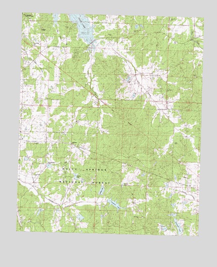
Coker Lake, MS USGS Topographic Map
Click on map above to begin viewing in our Map Viewer.

This topographic map contains these locations and features:
Feature Name Type Latitude Longitude GNIS ID View Map
Benson CemeteryCemeteryN34.1134°W89.8131°692539View Map
Buck Hill (historical)LocaleN34.0648°W89.7615°704573View Map
Chesnut LakeReservoirN34.0171°W89.8078°704574View Map
Coffeeville Lookout TowerTowerN34.0018°W89.7954°711501View Map
Coker LakeReservoirN34.0889°W89.8010°692940View Map
Coulter LakeReservoirN34.0218°W89.8168°695534View Map
Cypress Creek Watershed Y-19a-5 DamDamN34.0034°W89.7751°695529View Map
Cypress Creek Watershed Y-19a-6 DamDamN34.0251°W89.7668°695536View Map
Cypress Creek Watershed Y-19a-7 DamDamN34.0201°W89.7568°695532View Map
Cypress Creek Watershed Y-19a-8 DamDamN34.0334°W89.7684°695540View Map
Cypress Creek Watershed Y-19a-9 DamDamN34.0284°W89.7718°695537View Map
Dunavant LakeReservoirN34.0051°W89.7638°704577View Map
Erost CreekStreamN34.1076°W89.8265°693183View Map
Fords CemeteryCemeteryN34.1154°W89.7987°693241View Map
Fords Well (historical)LocaleN34.1148°W89.7973°705922View Map
Fords Well ChurchChurchN34.1154°W89.7987°693242View Map
Goshen CemeteryCemeteryN34.0332°W89.7592°693330View Map
Goshen ChurchChurchN34.0332°W89.7593°693331View Map
Guess CemeteryCemeteryN34.0394°W89.8435°693380View Map
Hatton (historical)LocaleN34.0904°W89.7859°704578View Map
Jackson LakeReservoirN34.0323°W89.8352°704579View Map
Larry Dyer Pond DamDamN34.0084°W89.8651°695530View Map
Leggo (historical)LocaleN34.1134°W89.7973°705926View Map
Lick Branch SchoolSchoolN34.0865°W89.8104°693723View Map
Locust Grove ChurchChurchN34.1207°W89.7765°693803View Map
Locust Grove SchoolSchoolN34.1207°W89.7765°693804View Map
Long Branch CemeteryCemeteryN34.0829°W89.7751°693822View Map
Nebo Store (historical)BuildingN34.1176°W89.7515°711111View Map
Philadelphia ChurchChurchN34.0515°W89.8387°694356View Map
Pipkin CemeteryCemeteryN34.0529°W89.7681°694408View Map
Roberson ChapelChurchN34.1154°W89.8609°694573View Map
Roberson SchoolSchoolN34.1154°W89.8609°694574View Map
Saint Andrews CemeteryCemeteryN34.1065°W89.8667°694637View Map
Saint Andrews ChurchChurchN34.1062°W89.8665°694638View Map
Salem CemeteryCemeteryN34.0912°W89.7548°694677View Map
Sardinia (historical)LocaleN34.1168°W89.8418°705933View Map
Sardinia CemeteryCemeteryN34.1165°W89.8434°694713View Map
Sayles CemeteryCemeteryN34.0504°W89.8640°694725View Map
Scurlock LakeReservoirN34.0282°W89.8029°704584View Map
Spring Hill CemeteryCemeteryN34.1237°W89.7729°694865View Map
Supervisor District 4CivilN34.0552°W89.8414°712151View Map
Swearengen CemeteryCemeteryN34.0332°W89.8642°694913View Map
Swearengen LakeReservoirN34.0379°W89.8538°704586View Map
Sweet Home ChurchChurchN34.0934°W89.8476°694914View Map
Tillatoba Creek Watershed Y-17b-8 DamDamN34.0334°W89.8334°695541View Map
Tillatoba Creek Y-17b-9 DamDamN34.0334°W89.8501°695542View Map
Tom Bell Lake DamDamN34.0868°W89.8001°695556View Map
W B Donovan Lake DamDamN34.0001°W89.7601°695527View Map
Walker LakeReservoirN34.0251°W89.8171°704589View Map
Yo-26-11 DamDamN34.0218°W89.8168°695533View Map
Yo-26-8 DamDamN34.0284°W89.8034°695538View Map
Zion Grove CemeteryCemeteryN34.0098°W89.7890°695240View Map
Zion Grove ChurchChurchN34.0098°W89.7915°695242View Map

Note: Coordinates in the location and feature list above are referenced to NAD83 datum.


Copyright (C) 2008-2024 Ryan Niemi / Sunset Dynamics ... All Rights Reserved