TopoQuest Logo
Do you find TopoQuest useful?
Help keep TopoQuest running and adding new maps/features by donating!
Bitcoin:  19c7KJd3qBynnjoSw5npx9KScwjBe4ifkT
Litecoin:  LXs6TkuXGGXo1vDsWCkWVdjQX94eUKd6ui
Home View Maps Find Maps Find Places Resources & Links


Sidney NE, Montana Topographic Map

USGS Map Title: Sidney NE, MT
USGS Map MRC: 47104F1
DRG (GeoTIFF) Download: o47104f1.tif


Neighboring USGS Topographic Map Quads:


  Fairview SW, MT  
47104G2
 

  Fairview, MT  
47104G1
 

  Cartwright, ND  
47103G8
 

  Sidney, MT  
47104F2
 

  Sidney NE, MT  
47104F1
 

  Horse Creek School, ND  
47103F8
 

  Piche, MT  
47104E2
 

  Sidney SE, MT  
47104E1
 

  Phillip Spring, ND  
47103E8


Map MRC Location:

N48°
W105°
N48°
W104°
H8 H7 H6 H5 H4 H3 H2 H1
G8 G7 G6 G5 G4 G3 G2 G1
F8 F7 F6 F5 F4 F3 F2 F1
E8 E7 E6 E5 E4 E3 E2 E1
D8 D7 D6 D5 D4 D3 D2 D1
C8 C7 C6 C5 C4 C3 C2 C1
B8 B7 B6 B5 B4 B3 B2 B1
A8 A7 A6 A5 A4 A3 A2 A1
N47°
W105°
N47°
W104°

Sidney NE, MT USGS 1:24K Topographic Map Preview:
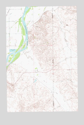
Sidney NE, MT USGS Topographic Map
Click on map above to begin viewing in our Map Viewer.

This topographic map contains these locations and features:
Feature Name Type Latitude Longitude GNIS ID View Map
22N59E02DA__01 WellWellN47.6945°W104.1019°824561View Map
22N59E03AA__01 WellWellN47.7017°W104.1233°824592View Map
22N59E03AA__02 WellWellN47.7017°W104.1233°824593View Map
22N59E11CD__01 WellWellN47.6764°W104.1127°824460View Map
22N59E11DDCB01 WellWellN47.6756°W104.1041°824458View Map
22N59E13CCBB01 WellWellN47.6511°W104.0988°824309View Map
22N59E14BABD01 WellWellN47.6731°W104.1130°824445View Map
22N59E14CB__01 WellWellN47.6653°W104.1174°824390View Map
22N59E24CBBD01 WellWellN47.6514°W104.0969°824311View Map
22N60E07CC__01 WellWellN47.6767°W104.0749°824464View Map
22N60E07CCDB01 WellWellN47.6753°W104.0741°824456View Map
23N52E28AA__01 WellWellN47.7320°W104.0449°824724View Map
23N59E13CC__01 WellWellN47.7495°W104.0966°824807View Map
23N59E13CCCC01 WellWellN47.7475°W104.0980°824797View Map
23N59E14CC__01 WellWellN47.7495°W104.1180°824808View Map
23N59E22DD__01 WellWellN47.7347°W104.1233°824741View Map
23N59E23AD__01 WellWellN47.7420°W104.1019°824770View Map
23N59E23BA__01 WellWellN47.7456°W104.1127°824781View Map
23N59E23DC__01 WellWellN47.7347°W104.1074°824740View Map
23N59E24AA__01 WellWellN47.7456°W104.0805°824779View Map
23N59E24BB__01 WellWellN47.7456°W104.0966°824780View Map
23N59E24DB__01 WellWellN47.7384°W104.0858°824758View Map
23N59E24DC__01 WellWellN47.7347°W104.0858°824739View Map
23N59E25AA__01 WellWellN47.7311°W104.0805°824714View Map
23N59E26AB__01 WellWellN47.7311°W104.1074°824715View Map
23N59E26BA__01 WellWellN47.7311°W104.1127°824716View Map
23N59E26CC__01 WellWellN47.7203°W104.1180°824678View Map
23N59E26DD__01 WellWellN47.7203°W104.1019°824677View Map
23N59E27AA__01 WellWellN47.7311°W104.1233°824717View Map
23N59E35BC__01 WellWellN47.7131°W104.1180°824651View Map
23N59E35DC__01 WellWellN47.7059°W104.1074°824625View Map
23N59E35DC__02 WellWellN47.7059°W104.1074°824626View Map
23N60E18DD__01 WellWellN47.7486°W104.0594°824803View Map
23N60E19AA__01 WellWellN47.7447°W104.0594°824778View Map
23N60E19BC__01 WellWellN47.7411°W104.0755°824768View Map
23N60E19CA__01 WellWellN47.7375°W104.0702°824752View Map
23N60E19CA__02 WellWellN47.7375°W104.0702°824753View Map
Alkali CreekStreamN47.6539°W104.0424°1034681View Map
Bennie Peer CreekStreamN47.6986°W104.0924°768704View Map
C Christenson RanchLocaleN47.6917°W104.0010°1035723View Map
Christensen DamDamN47.7400°W104.0622°796606View Map
Devitt CreekStreamN47.6322°W104.0291°770631View Map
Dodge WindmillLocaleN47.6742°W104.0130°1034832View Map
East Sidney SubstationLocaleN47.6759°W104.0760°794408View Map
Estes CouleeValleyN47.7486°W104.0324°1034859View Map
Estes SpringSpringN47.7272°W104.0191°1034861View Map
KSDY-FM (Sidney)TowerN47.6614°W104.1160°806717View Map
Lower Holly Sugar DamDamN47.7067°W104.1238°795509View Map
McGlynn DamDamN47.6631°W104.0724°774017View Map
McGlynn ReservoirReservoirN47.6596°W104.0778°795540View Map
McGlynn Reservoir DamDamN47.6634°W104.0738°795539View Map
R Burns RanchLocaleN47.7042°W104.0180°1035722View Map
Sturgis DamDamN47.7267°W104.0655°796532View Map
Thiel MineMineN47.7353°W104.0647°777555View Map

Note: Coordinates in the location and feature list above are referenced to NAD83 datum.


Copyright (C) 2008-2024 Ryan Niemi / Sunset Dynamics ... All Rights Reserved