TopoQuest Logo
Do you find TopoQuest useful?
Help keep TopoQuest running and adding new maps/features by donating!
Bitcoin:  19c7KJd3qBynnjoSw5npx9KScwjBe4ifkT
Litecoin:  LXs6TkuXGGXo1vDsWCkWVdjQX94eUKd6ui
Home View Maps Find Maps Find Places Resources & Links


Siseebakwet Lake, Minnesota Topographic Map

USGS Map Title: Siseebakwet Lake, MN
USGS Map MRC: 47093B6
DRG (GeoTIFF) Download: o47093b6.tif


Neighboring USGS Topographic Map Quads:


  Deer River, MN  
47093C7
 

  Cohasset West, MN  
47093C6
 

  Cohasset East, MN  
47093C5


  Siseebakwet Lake, MN  
47093B6
 

  Grand Rapids, MN  
47093B5


  Big Thunder Peak, MN  
47093A6
 

  Mountain Ash Lake, MN  
47093A5


Map MRC Location:

N48°
W94°
N48°
W93°
H8 H7 H6 H5 H4 H3 H2 H1
G8 G7 G6 G5 G4 G3 G2 G1
F8 F7 F6 F5 F4 F3 F2 F1
E8 E7 E6 E5 E4 E3 E2 E1
D8 D7 D6 D5 D4 D3 D2 D1
C8 C7 C6 C5 C4 C3 C2 C1
B8 B7 B6 B5 B4 B3 B2 B1
A8 A7 A6 A5 A4 A3 A2 A1
N47°
W94°
N47°
W93°

Siseebakwet Lake, MN USGS 1:24K Topographic Map Preview:
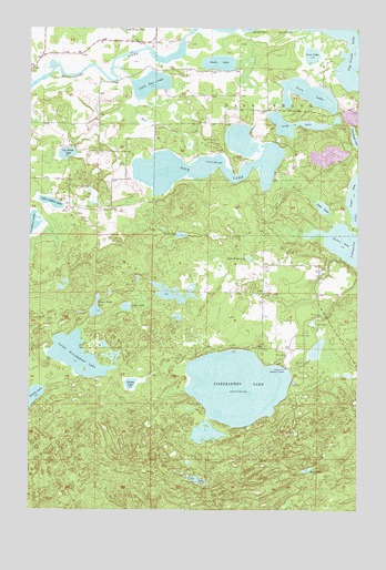
Siseebakwet Lake, MN USGS Topographic Map
Click on map above to begin viewing in our Map Viewer.

This topographic map contains these locations and features:
Feature Name Type Latitude Longitude GNIS ID View Map
Bass BrookPopulated PlaceN47.2383°W93.6466°1669537View Map
City of Bass Brook (historical)CivilN47.2391°W93.6397°2628230View Map
City of CohassetCivilN47.2390°W93.6396°2393586View Map
Compton Post Office (historical)Post OfficeN47.2494°W93.6253°2095333View Map
Cut-off LakeSwampN47.2472°W93.6631°655911View Map
Dead Horse LakeLakeN47.1903°W93.6668°655946View Map
Figure Eight LakeLakeN47.1771°W93.7249°656228View Map
Guile LakeLakeN47.2410°W93.6784°656471View Map
Irvin LakeLakeN47.1353°W93.6441°656716View Map
Little Leighton LakeLakeN47.2044°W93.7422°657081View Map
Little Rice LakeLakeN47.2354°W93.7045°657112View Map
Little Siseebakwet LakeLakeN47.1651°W93.7316°657127View Map
Long LakeLakeN47.1326°W93.6858°657184View Map
Long LakeLakeN47.2250°W93.6496°657185View Map
Loon LakeLakeN47.2329°W93.6445°657210View Map
Lost LakeLakeN47.2431°W93.6430°657221View Map
Lunch LakeLakeN47.1962°W93.6927°657260View Map
Rice CreekStreamN47.2397°W93.7188°658024View Map
Rice LakeLakeN47.2135°W93.6847°658029View Map
Salter BayBayN47.1930°W93.6280°658140View Map
Salter PondLakeN47.2034°W93.6386°658141View Map
Siseebakwet LakeLakeN47.1570°W93.6710°658276View Map
Skelly LakeLakeN47.1544°W93.7488°658287View Map
South Sugar LakeLakeN47.1449°W93.6829°1793654View Map
Spring LakeLakeN47.1577°W93.7115°658406View Map
Spruce LakeLakeN47.1776°W93.7133°658421View Map
Sugar Bay Campground ResortLocaleN47.1881°W93.6256°2096539View Map
Sugarbrooke Golf ClubLocaleN47.1625°W93.6514°2096540View Map
Township of Bass BrookCivilN47.2355°W93.6355°663518View Map
Township of Bass Brook (historical)CivilN47.2391°W93.6397°2628229View Map
Van Patter LakeLakeN47.2173°W93.7363°658834View Map

Note: Coordinates in the location and feature list above are referenced to NAD83 datum.


Copyright (C) 2008-2024 Ryan Niemi / Sunset Dynamics ... All Rights Reserved