TopoQuest Logo
Do you find TopoQuest useful?
Help keep TopoQuest running and adding new maps/features by donating!
Bitcoin:  19c7KJd3qBynnjoSw5npx9KScwjBe4ifkT
Litecoin:  LXs6TkuXGGXo1vDsWCkWVdjQX94eUKd6ui
Home View Maps Find Maps Find Places Resources & Links


Collier Draw, New Mexico Topographic Map

USGS Map Title: Collier Draw, NM
USGS Map MRC: 35106D8
DRG (GeoTIFF) Download: o35106d8.tif


Neighboring USGS Topographic Map Quads:


  Cabezon Peak, NM  
35107E1
 

  Ojito Spring, NM  
35106E8
 

  San Ysidro, NM  
35106E7
 

  Casa Salazar, NM  
35107D1
 

  Collier Draw, NM  
35106D8
 

  Cerro Conejo, NM  
35106D7
 

  Puerco Dam, NM  
35107C1
 

  San Felipe Mesa, NM  
35106C8
 

  Arroyo de las Calabacillas, NM  
35106C7


Map MRC Location:

N36°
W107°
N36°
W106°
H8 H7 H6 H5 H4 H3 H2 H1
G8 G7 G6 G5 G4 G3 G2 G1
F8 F7 F6 F5 F4 F3 F2 F1
E8 E7 E6 E5 E4 E3 E2 E1
D8 D7 D6 D5 D4 D3 D2 D1
C8 C7 C6 C5 C4 C3 C2 C1
B8 B7 B6 B5 B4 B3 B2 B1
A8 A7 A6 A5 A4 A3 A2 A1
N35°
W107°
N35°
W106°

Collier Draw, NM USGS 1:24K Topographic Map Preview:
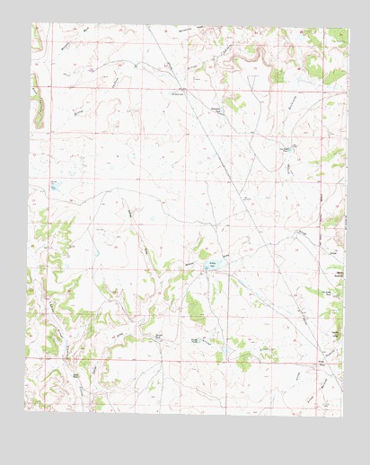
Collier Draw, NM USGS Topographic Map
Click on map above to begin viewing in our Map Viewer.

This topographic map contains these locations and features:
Feature Name Type Latitude Longitude GNIS ID View Map
Armijo DrawValleyN35.4167°W106.9470°885888View Map
Armijo LakeLakeN35.4233°W106.9273°885889View Map
Arroyo GriegoStreamN35.4006°W106.9600°897639View Map
Cerrito LargoSummitN35.4017°W106.8767°897865View Map
Cerrito RedondoSummitN35.4209°W106.8759°897869View Map
Collier DrawValleyN35.3800°W106.9753°887741View Map
Collier TankReservoirN35.3868°W106.9814°887743View Map
Emperado TankReservoirN35.4731°W106.9246°888872View Map
Griego TanksReservoirN35.3915°W106.8848°889631View Map
Huston TanksReservoirN35.3984°W106.9321°890276View Map
La Jara LakeReservoirN35.4781°W106.9448°890805View Map
Los Posos TankReservoirN35.4604°W106.8977°891377View Map
Old Sandy TankReservoirN35.4147°W106.8801°892892View Map
Red Gate DamDamN35.4467°W106.9906°893736View Map
Redgate DamDamN35.4459°W106.9884°924846View Map
Rio Salado North Detention Dam Number FiveDamN35.4967°W106.8939°923865View Map
Trujillo TankReservoirN35.3989°W106.9490°895853View Map

Note: Coordinates in the location and feature list above are referenced to NAD83 datum.


Copyright (C) 2008-2025 Ryan Niemi / Sunset Dynamics ... All Rights Reserved