TopoQuest Logo
Do you find TopoQuest useful?
Help keep TopoQuest running and adding new maps/features by donating!
Bitcoin:  19c7KJd3qBynnjoSw5npx9KScwjBe4ifkT
Litecoin:  LXs6TkuXGGXo1vDsWCkWVdjQX94eUKd6ui
Home View Maps Find Maps Find Places Resources & Links


Smiley, Texas Topographic Map

USGS Map Title: Smiley, TX
USGS Map MRC: 29097C6
DRG (GeoTIFF) Download: o29097c6.tif


Neighboring USGS Topographic Map Quads:


  Dewville, TX  
29097D7
 

  Leesville, TX  
29097D6
 

  Cost, TX  
29097D5
 

  Nixon, TX  
29097C7
 

  Smiley, TX  
29097C6
 

  Pilgrim, TX  
29097C5
 

  Gillett, TX  
29097B7
 

  Bald Mound, TX  
29097B6
 

  Sample, TX  
29097B5


Map MRC Location:

N30°
W98°
N30°
W97°
H8 H7 H6 H5 H4 H3 H2 H1
G8 G7 G6 G5 G4 G3 G2 G1
F8 F7 F6 F5 F4 F3 F2 F1
E8 E7 E6 E5 E4 E3 E2 E1
D8 D7 D6 D5 D4 D3 D2 D1
C8 C7 C6 C5 C4 C3 C2 C1
B8 B7 B6 B5 B4 B3 B2 B1
A8 A7 A6 A5 A4 A3 A2 A1
N29°
W98°
N29°
W97°

Smiley, TX USGS 1:24K Topographic Map Preview:
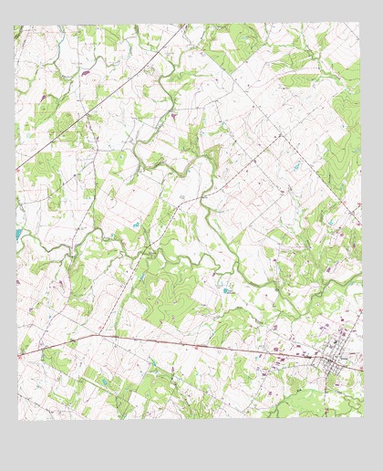
Smiley, TX USGS Topographic Map
Click on map above to begin viewing in our Map Viewer.

This topographic map contains these locations and features:
Feature Name Type Latitude Longitude GNIS ID View Map
Bundick CemeteryCemeteryN29.2733°W97.6603°1353305View Map
City of SmileyCivilN29.2713°W97.6376°2411910View Map
Clear Fork CreekStreamN29.2997°W97.6700°1354631View Map
Evans HollowValleyN29.2981°W97.6410°1357104View Map
Little Elm CreekStreamN29.2827°W97.6478°1361346View Map
Long HollowValleyN29.2920°W97.6388°1361730View Map
Nixon CemeteryCemeteryN29.2725°W97.7500°1363921View Map
O'Neal CreekStreamN29.3719°W97.7056°1375233View Map
Patterson LakeReservoirN29.2910°W97.6745°1364878View Map
Red BranchStreamN29.3089°W97.7453°1375661View Map
SchoollandPopulated PlaceN29.3339°W97.6644°2034841View Map
SmileyPopulated PlaceN29.2677°W97.6358°1368454View Map
Smiley Post OfficePost OfficeN29.2692°W97.6391°2731390View Map
Smiley Volunteer Fire DepartmentBuildingN29.2704°W97.6347°2552378View Map
Union Hill CemeteryCemeteryN29.3658°W97.6953°1370460View Map
Yow BranchStreamN29.3622°W97.6928°1376894View Map

Note: Coordinates in the location and feature list above are referenced to NAD83 datum.


Copyright (C) 2008-2025 Ryan Niemi / Sunset Dynamics ... All Rights Reserved