TopoQuest Logo
Do you find TopoQuest useful?
Help keep TopoQuest running and adding new maps/features by donating!
Bitcoin:  19c7KJd3qBynnjoSw5npx9KScwjBe4ifkT
Litecoin:  LXs6TkuXGGXo1vDsWCkWVdjQX94eUKd6ui
Home View Maps Find Maps Find Places Resources & Links


Smith Creek, Florida Topographic Map

USGS Map Title: Smith Creek, FL
USGS Map MRC: 30084B6
DRG (GeoTIFF) Download: o30084b6.tif


Neighboring USGS Topographic Map Quads:


  Telogia, FL  
30084C7
 

  Ward, FL  
30084C6
 

  Lake Talquin SE, FL  
30084C5
 

  Queens Bay, FL  
30084B7
 

  Smith Creek, FL  
30084B6
 

  Bradwell Bay, FL  
30084B5
 

  Owens Bridge, FL  
30084A7
 

  Thousand Yard Bay, FL  
30084A6
 

  Sanborn, FL  
30084A5


Map MRC Location:

N31°
W85°
N31°
W84°
H8 H7 H6 H5 H4 H3 H2 H1
G8 G7 G6 G5 G4 G3 G2 G1
F8 F7 F6 F5 F4 F3 F2 F1
E8 E7 E6 E5 E4 E3 E2 E1
D8 D7 D6 D5 D4 D3 D2 D1
C8 C7 C6 C5 C4 C3 C2 C1
B8 B7 B6 B5 B4 B3 B2 B1
A8 A7 A6 A5 A4 A3 A2 A1
N30°
W85°
N30°
W84°

Smith Creek, FL USGS 1:24K Topographic Map Preview:
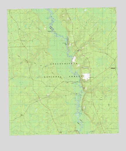
Smith Creek, FL USGS Topographic Map
Click on map above to begin viewing in our Map Viewer.

This topographic map contains these locations and features:
Feature Name Type Latitude Longitude GNIS ID View Map
Allen LandingLocaleN30.1483°W84.6696°305201View Map
Alligator PondsLakeN30.2491°W84.7416°305210View Map
Apalachicola National ForestForestN30.1931°W84.6940°306956View Map
Apalachicola TrailTrailN30.2024°W84.7457°307081View Map
Apalachicola Wildlife Management AreaParkN30.2085°W84.6666°306957View Map
Betsy BranchStreamN30.2088°W84.6805°305284View Map
Big River LandingLocaleN30.1721°W84.6652°305302View Map
Blazed Pine LandingLocaleN30.2266°W84.6996°305330View Map
Buck BaySwampN30.2332°W84.7275°305390View Map
Bulloch BranchStreamN30.2391°W84.7107°305411View Map
Cat BranchStreamN30.2024°W84.7207°305455View Map
Coxes BranchStreamN30.1974°W84.7227°305518View Map
East CampLocaleN30.1449°W84.7341°305612View Map
Flat BranchStreamN30.1680°W84.6430°305676View Map
Frog LakeLakeN30.1450°W84.6691°305708View Map
Gully BranchStreamN30.1452°W84.6860°305771View Map
Hickory BranchStreamN30.1946°W84.6913°305804View Map
Highlog LakeLakeN30.2406°W84.6998°305811View Map
Indian CreekStreamN30.2105°W84.7032°305853View Map
Jewel Fire TowerTowerN30.1969°W84.7274°305871View Map
Langston BranchStreamN30.1463°W84.6682°305930View Map
Little Reedy BranchStreamN30.2244°W84.7227°305969View Map
Lower Langston LandingLocaleN30.1288°W84.6713°305992View Map
Mill CreekStreamN30.2027°W84.6763°306044View Map
Mount Elan ChurchChurchN30.2080°W84.6677°306077View Map
North Branch Smith CreekStreamN30.1710°W84.6507°306118View Map
Old LakeLakeN30.2190°W84.6816°306152View Map
Pine CreekStreamN30.2444°W84.6974°306221View Map
Pine Creek Landing CampgroundLocaleN30.2463°W84.6966°307822View Map
Poplar CampLocaleN30.1263°W84.6907°306248View Map
Porter LakeLakeN30.1760°W84.6745°306251View Map
Porter Lake CampgroundLocaleN30.1627°W84.6749°307825View Map
Preachers BaySwampN30.1528°W84.7305°306258View Map
Reedy BranchStreamN30.2208°W84.6921°306277View Map
Smith CreekPopulated PlaceN30.1819°W84.6569°304740View Map
Smith CreekStreamN30.1663°W84.6627°306405View Map
Smith Creek SchoolSchoolN30.1880°W84.6563°306407View Map
Smith Creek Volunteer Fire Department Station 9BuildingN30.1879°W84.6567°2644149View Map
Stallion BaySwampN30.1462°W84.7227°306445View Map
Tama (historical)Populated PlaceN30.1502°W84.6832°306983View Map
Tiger CreekStreamN30.1627°W84.6866°306498View Map
Tiger CreekStreamN30.1788°W84.7419°306499View Map
Tin Top BaySwampN30.1715°W84.7407°306502View Map
Upper Langston LandingLocaleN30.2144°W84.6810°306536View Map
Wethocouchy (historical)Populated PlaceN30.2335°W84.6666°306984View Map
Whitehead LakeLakeN30.1588°W84.6728°306593View Map
Whitehead Lake CampgroundLocaleN30.1766°W84.6763°307824View Map
Wolf BranchStreamN30.2421°W84.7102°306604View Map
X L LakeLakeN30.1382°W84.6716°306619View Map

Note: Coordinates in the location and feature list above are referenced to NAD83 datum.


Copyright (C) 2008-2025 Ryan Niemi / Sunset Dynamics ... All Rights Reserved