TopoQuest Logo
Do you find TopoQuest useful?
Help keep TopoQuest running and adding new maps/features by donating!
Bitcoin:  19c7KJd3qBynnjoSw5npx9KScwjBe4ifkT
Litecoin:  LXs6TkuXGGXo1vDsWCkWVdjQX94eUKd6ui
Home View Maps Find Maps Find Places Resources & Links


Smithton, Pennsylvania Topographic Map

USGS Map Title: Smithton, PA
USGS Map MRC: 40079B6
DRG (GeoTIFF) Download: o40079b6.tif


Neighboring USGS Topographic Map Quads:


  McKeesport, PA  
40079C7
 

  Irwin, PA  
40079C6
 

  Greensburg, PA  
40079C5
 

  Donora, PA  
40079B7
 

  Smithton, PA  
40079B6
 

  Mount Pleasant, PA  
40079B5
 

  Fayette City, PA  
40079A7
 

  Dawson, PA  
40079A6
 

  Connellsville, PA  
40079A5


Map MRC Location:

N41°
W80°
N41°
W79°
H8 H7 H6 H5 H4 H3 H2 H1
G8 G7 G6 G5 G4 G3 G2 G1
F8 F7 F6 F5 F4 F3 F2 F1
E8 E7 E6 E5 E4 E3 E2 E1
D8 D7 D6 D5 D4 D3 D2 D1
C8 C7 C6 C5 C4 C3 C2 C1
B8 B7 B6 B5 B4 B3 B2 B1
A8 A7 A6 A5 A4 A3 A2 A1
N40°
W80°
N40°
W79°

Smithton, PA USGS 1:24K Topographic Map Preview:
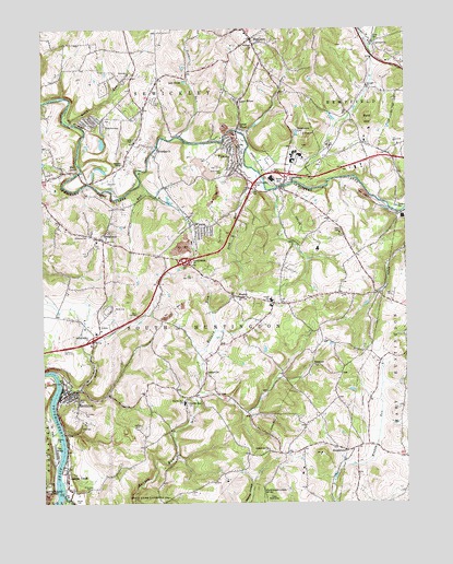
Smithton, PA USGS Topographic Map
Click on map above to begin viewing in our Map Viewer.

This topographic map contains these locations and features:
Feature Name Type Latitude Longitude GNIS ID View Map
Bald HillSummitN40.2259°W79.6370°1168633View Map
Barren Run ChurchChurchN40.1512°W79.7000°1168760View Map
Barren Run SchoolSchoolN40.1517°W79.7000°1168761View Map
Borough of MadisonCivilN40.2456°W79.6749°1215707View Map
Borough of SmithtonCivilN40.1537°W79.7419°1215722View Map
Buffalo RunStreamN40.2017°W79.6250°1170617View Map
Cameron SchoolSchoolN40.2251°W79.7278°1170964View Map
CentervillePopulated PlaceN40.1592°W79.6937°1171470View Map
CentervillePopulated PlaceN40.2459°W79.6350°1171471View Map
Delmont Mine Refuse Bank DamDamN40.2001°W79.6414°1194625View Map
Diamond SchoolSchoolN40.2473°W79.6373°1173228View Map
Dick ChurchChurchN40.2378°W79.7184°1173239View Map
Dutch HollowValleyN40.1554°W79.7370°1173657View Map
Errett CemeteryCemeteryN40.2467°W79.6342°1174312View Map
EurekaPopulated PlaceN40.1467°W79.7364°1203532View Map
Fort Robinson SchoolSchoolN40.1881°W79.6989°1175019View Map
Fresh Water Supply PondReservoirN40.2198°W79.7291°1194639View Map
Glenwood ChurchChurchN40.1612°W79.6562°1175744View Map
Grace ChurchChurchN40.2190°W79.6820°1175893View Map
Grand View ChurchChurchN40.1390°W79.6723°1175933View Map
Greek ChurchChurchN40.1337°W79.7417°1176053View Map
Hoffman CemeteryCemeteryN40.1448°W79.7164°1177160View Map
Hunters RunStreamN40.2092°W79.7159°1177617View Map
HutchinsonPopulated PlaceN40.2262°W79.7317°1177660View Map
Hutchinson Mine Refuse Bank DamDamN40.2184°W79.7298°1194640View Map
Hutchinson Post OfficePost OfficeN40.2260°W79.7314°2772757View Map
Interchange 53CrossingN40.2091°W79.6767°2431685View Map
Interchange 54CrossingN40.2115°W79.6662°2431686View Map
Jacobs CreekPopulated PlaceN40.1331°W79.7417°1177958View Map
Jacobs CreekStreamN40.1270°W79.7431°1177960View Map
Jacobs Creek ChurchChurchN40.1287°W79.7412°1177962View Map
Jacobs Creek Post OfficePost OfficeN40.1331°W79.7415°2773168View Map
Kelly RunStreamN40.2251°W79.7400°1178336View Map
Lake DenisePopulated PlaceN40.2362°W79.6998°1178774View Map
Lick RunStreamN40.2081°W79.6725°1179295View Map
Lower WhyelPopulated PlaceN40.2237°W79.6820°1180040View Map
MadisonPopulated PlaceN40.2473°W79.6773°1180176View Map
Madison ChurchChurchN40.2456°W79.6764°1180177View Map
Madison Post OfficePost OfficeN40.2463°W79.6771°2773194View Map
Madison Volunteer Fire DepartmentBuildingN40.2489°W79.6799°2645549View Map
Markle CemeteryCemeteryN40.2065°W79.7303°1180422View Map
MendonPopulated PlaceN40.1795°W79.6837°1180924View Map
MilbellPopulated PlaceN40.2190°W79.7095°1181095View Map
Milbell CemeteryCemeteryN40.2176°W79.7106°1181096View Map
Mill GrovePopulated PlaceN40.2126°W79.7398°1204176View Map
Mineral Number 14 SchoolSchoolN40.1523°W79.7337°1181315View Map
Painters RunStreamN40.2078°W79.7142°1183211View Map
Pinkerton RunStreamN40.2217°W79.7020°1183945View Map
ReagantownPopulated PlaceN40.1395°W79.6487°1184738View Map
Ruffsdale Airpark (historical)AirportN40.1834°W79.6281°1213748View Map
Saint Timothys CemeteryCemeteryN40.1492°W79.7373°1186758View Map
Seanor ChurchChurchN40.2348°W79.6375°1187198View Map
Sewickley ChurchChurchN40.2181°W79.7098°1187281View Map
Sewickley GrangeLocaleN40.2145°W79.7217°1187284View Map
Sewickley Township Volunteer Fire Company 4BuildingN40.2255°W79.7296°2645608View Map
SmithtonPopulated PlaceN40.1540°W79.7412°1187908View Map
Smithton Post OfficePost OfficeN40.1546°W79.7408°2779818View Map
Smithton Volunteer Fire DepartmentBuildingN40.1546°W79.7419°2645085View Map
South Huntingdon Township High SchoolSchoolN40.1784°W79.6709°1188084View Map
Township of South HuntingdonCivilN40.1702°W79.7001°1217258View Map
TurkeytownPopulated PlaceN40.1951°W79.7300°1189956View Map
Turkeytown Volunteer Fire DepartmentBuildingN40.1942°W79.7309°2644980View Map
Upper WhyelPopulated PlaceN40.2315°W79.6812°1190263View Map
Van MeterPopulated PlaceN40.1390°W79.7456°1190338View Map
Waltz MillPopulated PlaceN40.2087°W79.6675°1190570View Map
Westinghouse Waltz Mills Fire DepartmentBuildingN40.2161°W79.6649°2645690View Map
WyanoPopulated PlaceN40.1973°W79.6973°1191821View Map
Wyano Census Designated PlaceCensusN40.2015°W79.6939°2633877View Map
Wyano Post OfficePost OfficeN40.1948°W79.6972°2779656View Map
YukonPopulated PlaceN40.2126°W79.6828°1191930View Map
Yukon - South Huntingdon Township Volunteer Fire CompanyBuildingN40.2140°W79.6820°2645548View Map
Yukon CemeteryCemeteryN40.2117°W79.6870°1191931View Map
Yukon Census Designated PlaceCensusN40.2139°W79.6864°2633879View Map
Yukon Post OfficePost OfficeN40.2147°W79.6822°2773057View Map

Note: Coordinates in the location and feature list above are referenced to NAD83 datum.


Copyright (C) 2008-2024 Ryan Niemi / Sunset Dynamics ... All Rights Reserved