TopoQuest Logo
Do you find TopoQuest useful?
Help keep TopoQuest running and adding new maps/features by donating!
Bitcoin:  19c7KJd3qBynnjoSw5npx9KScwjBe4ifkT
Litecoin:  LXs6TkuXGGXo1vDsWCkWVdjQX94eUKd6ui
Home View Maps Find Maps Find Places Resources & Links


Smithville, Texas Topographic Map

USGS Map Title: Smithville, TX
USGS Map MRC: 30097A2
DRG (GeoTIFF) Download: o30097a2.tif


Neighboring USGS Topographic Map Quads:


  Lake Bastrop, TX  
30097B3
 

  Smithville NW, TX  
30097B2
 

  Paige, TX  
30097B1
 

  Bastrop, TX  
30097A3
 

  Smithville, TX  
30097A2
 

  Winchester, TX  
30097A1
 

  Rosanky, TX  
29097H3
 

  Togo, TX  
29097H2
 

  West Point, TX  
29097H1


Map MRC Location:

N31°
W98°
N31°
W97°
H8 H7 H6 H5 H4 H3 H2 H1
G8 G7 G6 G5 G4 G3 G2 G1
F8 F7 F6 F5 F4 F3 F2 F1
E8 E7 E6 E5 E4 E3 E2 E1
D8 D7 D6 D5 D4 D3 D2 D1
C8 C7 C6 C5 C4 C3 C2 C1
B8 B7 B6 B5 B4 B3 B2 B1
A8 A7 A6 A5 A4 A3 A2 A1
N30°
W98°
N30°
W97°

Smithville, TX USGS 1:24K Topographic Map Preview:
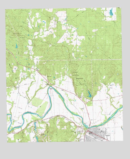
Smithville, TX USGS Topographic Map
Click on map above to begin viewing in our Map Viewer.

This topographic map contains these locations and features:
Feature Name Type Latitude Longitude GNIS ID View Map
A J Rod DamDamN30.0186°W97.2186°1862691View Map
A J Rod LakeReservoirN30.0151°W97.2197°1862692View Map
Alum CreekPopulated PlaceN30.0677°W97.2175°1377933View Map
Alum CreekStreamN30.0522°W97.2028°1329473View Map
Bastrop County Constable's Office Precinct 2BuildingN30.0010°W97.1434°2739350View Map
Bastrop County Historical MuseumBuildingN30.0119°W97.1575°2014304View Map
Brown Primary SchoolSchoolN30.0036°W97.1658°2002942View Map
Buescher LakeReservoirN30.0437°W97.1604°1859594View Map
Buescher State ParkParkN30.0594°W97.1705°1331554View Map
Buescher State Park Hiking TrailTrailN30.0494°W97.1614°2032965View Map
Buescher State Park Lake DamDamN30.0419°W97.1603°1859593View Map
Carl and Mary Welhausen LibraryBuildingN30.1247°W97.1494°2014981View Map
City of SmithvilleCivilN30.0069°W97.1508°2411912View Map
Dancing Turtles LakeReservoirN30.0833°W97.1897°2434932View Map
Droemer DamDamN30.1169°W97.1369°1859591View Map
Droemer LakeReservoirN30.1169°W97.1369°1859592View Map
East Fork Gravelly CreekStreamN30.1169°W97.1417°1334920View Map
First Presbyterian ChurchChurchN30.0074°W97.1567°2016497View Map
Gazley CemeteryCemeteryN30.0009°W97.1736°1376440View Map
Gazley CreekStreamN30.0122°W97.1642°1373822View Map
Grace Lutheran ChurchChurchN30.0044°W97.1497°2016493View Map
Hardeman BendBendN30.0480°W97.2019°1337330View Map
Harmon DamDamN30.0902°W97.2369°1859597View Map
Harmon LakeReservoirN30.0901°W97.2385°1859598View Map
Harts Chapel United Methodist ChurchChurchN30.0063°W97.1650°2016495View Map
Hunt BranchStreamN30.0205°W97.1405°1351063View Map
J D CreekStreamN30.0302°W97.1317°1338526View Map
Kennedy BluffsCliffN30.0536°W97.2033°1339036View Map
KOKE-FM (Giddings)TowerN30.0152°W97.1997°1385865View Map
Larry ChapelChurchN30.0386°W97.1486°1339640View Map
Line CreekStreamN30.0219°W97.2167°1374540View Map
Little Alum CreekStreamN30.0397°W97.2239°1374547View Map
MetroCare Services Smithville StationBuildingN30.0026°W97.1465°2655982View Map
Mill CreekStreamN30.0144°W97.2355°1374938View Map
Mount Pilgrim Baptist ChurchChurchN30.0036°W97.1642°2016480View Map
Pigeonroost HollowValleyN30.0621°W97.2416°1343990View Map
Powell CemeteryCemeteryN30.0419°W97.1711°1329507View Map
Reeds CreekStreamN30.0108°W97.2489°1375691View Map
Rod Lake Number 1 DamDamN30.0002°W97.2169°1865399View Map
Rod Lake Number 2ReservoirN30.0037°W97.2182°1865402View Map
Rod Lake Number 2 DamDamN30.0052°W97.2186°1865401View Map
Saint Pauls Catholic ChurchChurchN30.0052°W97.1539°2016487View Map
Seton Smithville Regional HospitalHospitalN30.0039°W97.1360°2015612View Map
SmithvillePopulated PlaceN30.0086°W97.1594°1376161View Map
Smithville City HallBuildingN30.0092°W97.1596°2753448View Map
Smithville Commercial Historic DistrictLocaleN30.0091°W97.1611°2031933View Map
Smithville Community Police FacilityBuildingN30.0031°W97.1431°2739432View Map
Smithville Crawford Municipal AirportAirportN30.0305°W97.1669°1387554View Map
Smithville Elementary SchoolSchoolN30.0087°W97.1490°2002956View Map
Smithville Police DepartmentBuildingN30.0095°W97.1598°2739256View Map
Smithville Post OfficePost OfficeN30.0094°W97.1587°2731377View Map
Smithville Railroad Historical Park and MuseumBuildingN30.0413°W97.1383°2014309View Map
Smithville Residential Historic DistrictLocaleN30.0094°W97.1567°2031934View Map
Smithville Volunteer Fire DepartmentBuildingN30.0093°W97.1624°2552649View Map
Smithville Volunteer Fire Department Station 2BuildingN30.0026°W97.1554°2552366View Map
West Fork Gravelly CreekStreamN30.1166°W97.1414°1349725View Map
Wolf CreekStreamN30.0222°W97.2128°1376847View Map

Note: Coordinates in the location and feature list above are referenced to NAD83 datum.


Copyright (C) 2008-2024 Ryan Niemi / Sunset Dynamics ... All Rights Reserved