TopoQuest Logo
Do you find TopoQuest useful?
Help keep TopoQuest running and adding new maps/features by donating!
Bitcoin:  19c7KJd3qBynnjoSw5npx9KScwjBe4ifkT
Litecoin:  LXs6TkuXGGXo1vDsWCkWVdjQX94eUKd6ui
Home View Maps Find Maps Find Places Resources & Links


Lake Bastrop, Texas Topographic Map

USGS Map Title: Lake Bastrop, TX
USGS Map MRC: 30097B3
DRG (GeoTIFF) Download: o30097b3.tif


Neighboring USGS Topographic Map Quads:


  Elgin West, TX  
30097C4
 

  Elgin East, TX  
30097C3
 

  McDade, TX  
30097C2
 

  Utley, TX  
30097B4
 

  Lake Bastrop, TX  
30097B3
 

  Smithville NW, TX  
30097B2
 

  Bastrop SW, TX  
30097A4
 

  Bastrop, TX  
30097A3
 

  Smithville, TX  
30097A2


Map MRC Location:

N31°
W98°
N31°
W97°
H8 H7 H6 H5 H4 H3 H2 H1
G8 G7 G6 G5 G4 G3 G2 G1
F8 F7 F6 F5 F4 F3 F2 F1
E8 E7 E6 E5 E4 E3 E2 E1
D8 D7 D6 D5 D4 D3 D2 D1
C8 C7 C6 C5 C4 C3 C2 C1
B8 B7 B6 B5 B4 B3 B2 B1
A8 A7 A6 A5 A4 A3 A2 A1
N30°
W98°
N30°
W97°

Lake Bastrop, TX USGS 1:24K Topographic Map Preview:
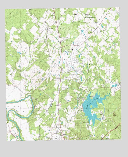
Lake Bastrop, TX USGS Topographic Map
Click on map above to begin viewing in our Map Viewer.

This topographic map contains these locations and features:
Feature Name Type Latitude Longitude GNIS ID View Map
Big Sandy CreekStreamN30.1658°W97.3542°1372564View Map
Camp SwiftMilitaryN30.2279°W97.2915°2512073View Map
Camp SwiftPopulated PlaceN30.1908°W97.2922°1867544View Map
Camp Swift Census Designated PlaceCensusN30.1885°W97.2933°2407948View Map
Circle D Fire StationBuildingN30.1734°W97.2566°2552220View Map
Colorado SchoolSchoolN30.1447°W97.3742°1333145View Map
Cuero Public LibraryBuildingN30.1299°W97.2905°2015009View Map
Federal Correctional Institution BastropBuildingN30.1914°W97.3079°2738869View Map
Grimes SchoolSchoolN30.1622°W97.3200°1337034View Map
Hicks LakeReservoirN30.1759°W97.2585°1865365View Map
Hicks Lake DamDamN30.1752°W97.2586°1865364View Map
Lake BastropReservoirN30.1463°W97.2772°1859608View Map
Lake Bastrop - North Shores ParkParkN30.1691°W97.2792°2029023View Map
Lake Bastrop - South Shores ParkParkN30.1416°W97.2861°2029024View Map
Lake Bastrop DamDamN30.1552°W97.2919°1859607View Map
Lake Bastrop Volunteer Fire DepartmentBuildingN30.1850°W97.3102°2552219View Map
Little Sandy CreekStreamN30.2385°W97.3378°1340183View Map
PhelanPopulated PlaceN30.1588°W97.3261°1378855View Map
Pine HillsPopulated PlaceN30.1385°W97.2533°2413662View Map
Powell BendBendN30.1560°W97.3536°1344451View Map
Reed BendBendN30.1488°W97.3680°1344991View Map
Sanders DamDamN30.1552°W97.2969°1859603View Map
Sanders LakeReservoirN30.1552°W97.2969°1859604View Map
SayersvillePopulated PlaceN30.2319°W97.3272°1346746View Map
Spicer CreekStreamN30.1499°W97.2989°1347651View Map
SwiftexPopulated PlaceN30.2063°W97.3136°2034781View Map
Tuck LakeReservoirN30.1828°W97.2928°1865363View Map
Tuck Lake DamDamN30.1802°W97.2936°1865362View Map

Note: Coordinates in the location and feature list above are referenced to NAD83 datum.


Copyright (C) 2008-2025 Ryan Niemi / Sunset Dynamics ... All Rights Reserved