TopoQuest Logo
Do you find TopoQuest useful?
Help keep TopoQuest running and adding new maps/features by donating!
Bitcoin:  19c7KJd3qBynnjoSw5npx9KScwjBe4ifkT
Litecoin:  LXs6TkuXGGXo1vDsWCkWVdjQX94eUKd6ui
Home View Maps Find Maps Find Places Resources & Links


Smyrna, Delaware Topographic Map

USGS Map Title: Smyrna, DE
USGS Map MRC: 39075C5
DRG (GeoTIFF) Download: o39075c5.tif


Neighboring USGS Topographic Map Quads:


  Middletown, DE  
39075D6
 

  Taylors Bridge, DE  
39075D5
 

  Canton, NJ  
39075D4
 

  Clayton, DE  
39075C6
 

  Smyrna, DE  
39075C5
 

  Bombay Hook Island, DE  
39075C4
 

  Kenton, DE  
39075B6
 

  Dover, DE  
39075B5
 

  Little Creek, DE  
39075B4


Map MRC Location:

N40°
W76°
N40°
W75°
H8 H7 H6 H5 H4 H3 H2 H1
G8 G7 G6 G5 G4 G3 G2 G1
F8 F7 F6 F5 F4 F3 F2 F1
E8 E7 E6 E5 E4 E3 E2 E1
D8 D7 D6 D5 D4 D3 D2 D1
C8 C7 C6 C5 C4 C3 C2 C1
B8 B7 B6 B5 B4 B3 B2 B1
A8 A7 A6 A5 A4 A3 A2 A1
N39°
W76°
N39°
W75°

Smyrna, DE USGS 1:24K Topographic Map Preview:
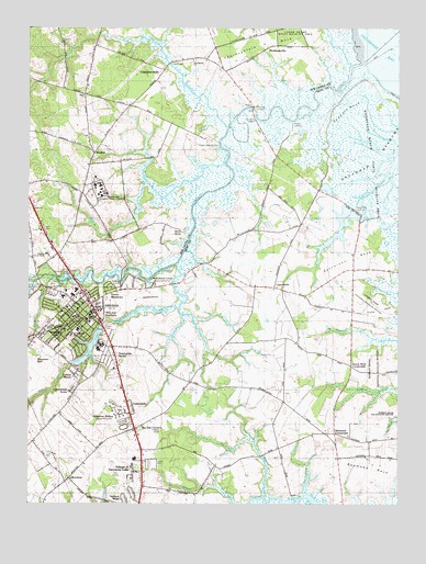
Smyrna, DE USGS Topographic Map
Click on map above to begin viewing in our Map Viewer.

This topographic map contains these locations and features:
Feature Name Type Latitude Longitude GNIS ID View Map
American Legion AmbulanceBuildingN39.3018°W75.6118°2642772View Map
Appoqueneme (historical)SwampN39.3626°W75.5163°217642View Map
Asbury United Methodist ChurchChurchN39.3012°W75.6080°215027View Map
Bannister HallLocaleN39.2893°W75.6213°213599View Map
Belmont HallLocaleN39.2943°W75.5958°213632View Map
Bennefield BranchStreamN39.2526°W75.5316°217070View Map
Bethel African Methodist Episcopal ChurchChurchN39.3018°W75.6052°215026View Map
Big Oak CornersPopulated PlaceN39.2696°W75.5885°213661View Map
Bombay WoodsPopulated PlaceN39.2884°W75.5909°2400386View Map
BrenfordPopulated PlaceN39.2565°W75.6108°216048View Map
Brick StorePopulated PlaceN39.3221°W75.5727°216049View Map
Broadway MeadowsSwampN39.3404°W75.5077°216370View Map
Burtonwood VillagePopulated PlaceN39.2726°W75.5864°2400387View Map
CarroltownLocaleN39.3071°W75.5419°217066View Map
Cedarbrook AcresPopulated PlaceN39.2793°W75.6094°217058View Map
Centennial United Methodist ChurchChurchN39.3012°W75.6083°215028View Map
ChambersvillePopulated PlaceN39.3637°W75.5788°216058View Map
Church of the NazareneChurchN39.2965°W75.6066°215036View Map
Citizens' Hose Company Number 1BuildingN39.2991°W75.6082°2610838View Map
Colmar ManorPopulated PlaceN39.2834°W75.6094°217059View Map
Commerce SquarePopulated PlaceN39.3018°W75.5963°2400380View Map
Corks Point DitchStreamN39.3393°W75.5583°213832View Map
DeakynevillePopulated PlaceN39.3693°W75.5444°216078View Map
Delaware Correctional CenterLocaleN39.3359°W75.6030°215599View Map
Delaware State Emergency Management AgencyBuildingN39.3191°W75.6074°2378379View Map
Duck CreekStreamN39.3129°W75.5746°213911View Map
Duck Creek HundredCivilN39.2918°W75.5080°217211View Map
Duck Creek LandingPopulated PlaceN39.3189°W75.5652°2400377View Map
Duck Creek Pond DamDamN39.3082°W75.6224°217072View Map
Dutch Neck CrossroadsPopulated PlaceN39.2862°W75.5158°216084View Map
Eagles Nest LandingPopulated PlaceN39.3454°W75.5633°216085View Map
East Elementary Early Childhood CenterSchoolN39.3004°W75.6013°214971View Map
First Presbyterian ChurchChurchN39.2990°W75.6077°215025View Map
Fleming House (historical)BuildingN39.3543°W75.5066°1877472View Map
Flemings LandingPopulated PlaceN39.3540°W75.5485°216096View Map
Friendship United Methodist ChurchChurchN39.3665°W75.5691°216331View Map
GardensidePopulated PlaceN39.2875°W75.6152°2400382View Map
Garrison Lake Golf CourseLocaleN39.2559°W75.5995°2378678View Map
Hay Point LandingPopulated PlaceN39.3515°W75.5483°217063View Map
Hedgerow Hollow Mobile Home ParkPopulated PlaceN39.2709°W75.5905°216651View Map
Hickory RidgePopulated PlaceN39.2507°W75.5927°215594View Map
Interchange 114CrossingN39.2821°W75.5899°2400369View Map
Ivy Dale Farm (historical)LocaleN39.2854°W75.5774°1877476View Map
James T Vaughn Correctional CenterBuildingN39.3353°W75.5997°2722675View Map
John Bassett Moore Middle SchoolSchoolN39.2984°W75.6052°217808View Map
Lake ComoReservoirN39.2907°W75.6045°213820View Map
Lake Como DamDamN39.2965°W75.5999°217071View Map
LawndalePopulated PlaceN39.2765°W75.5905°217057View Map
Little NeckCapeN39.3001°W75.5080°217067View Map
Long BridgeBridgeN39.3654°W75.5769°214248View Map
Long Point LandingPopulated PlaceN39.3076°W75.6205°217061View Map
Loving Care Nursery School and Kindergarten, IncorporatedSchoolN39.2696°W75.5874°214895View Map
Mallards RunPopulated PlaceN39.3033°W75.5992°2400379View Map
MaplehurstPopulated PlaceN39.2508°W75.5740°2400407View Map
Mill CreekStreamN39.3129°W75.5746°214313View Map
MillcreekPopulated PlaceN39.2903°W75.6186°2400381View Map
Morris BranchStreamN39.3348°W75.5852°217062View Map
Mount Olive Pentecostal ChurchChurchN39.3040°W75.6074°217900View Map
Nandains LandingPopulated PlaceN39.2626°W75.5274°216730View Map
Newberg AirportAirportN39.2893°W75.5802°2625373View Map
North Gateway Shopping CenterLocaleN39.2800°W75.5913°2378701View Map
Peace Lutheran ChurchChurchN39.2919°W75.6234°2378643View Map
RavenwoodPopulated PlaceN39.2900°W75.5573°2400378View Map
Raymond NeckCapeN39.2596°W75.5080°216403View Map
Ridgewood ManorPopulated PlaceN39.2604°W75.5831°2400388View Map
Saint Peters ChurchChurchN39.2987°W75.6102°215037View Map
Saint Polycarp Catholic ChurchChurchN39.2946°W75.6108°215035View Map
Salisbury (historical)LocaleN39.3071°W75.6205°215021View Map
Sawmill BranchStreamN39.3487°W75.5574°214620View Map
Serverson NeckCapeN39.3140°W75.5166°214631View Map
SheridenPopulated PlaceN39.2850°W75.6038°2400384View Map
Shorts LandingPopulated PlaceN39.3498°W75.5355°216217View Map
SmyrnaPopulated PlaceN39.2998°W75.6046°214671View Map
Smyrna AirportAirportN39.3036°W75.5863°217245View Map
Smyrna Christian SchoolSchoolN39.3152°W75.6196°215012View Map
Smyrna City HallBuildingN39.2992°W75.6067°2378667View Map
Smyrna DivisionCivilN39.2918°W75.5004°1935626View Map
Smyrna Elementary SchoolSchoolN39.2961°W75.6081°214970View Map
Smyrna LandingPopulated PlaceN39.3082°W75.5935°216221View Map
Smyrna Middle SchoolSchoolN39.3021°W75.6237°214967View Map
Smyrna Municipal ParkParkN39.3073°W75.6158°2053040View Map
Smyrna North Elementary SchoolSchoolN39.3043°W75.6141°214972View Map
Smyrna Police DepartmentBuildingN39.2998°W75.6141°2131096View Map
Smyrna Post OfficePost OfficeN39.2995°W75.6071°2378666View Map
Smyrna Public LibraryBuildingN39.2998°W75.6044°2378671View Map
Smyrna RiverStreamN39.3651°W75.5133°214672View Map
Smyrna School DistrictCivilN39.3004°W75.6052°2053039View Map
Spruance CityPopulated PlaceN39.2946°W75.6163°217060View Map
Spruances BranchStreamN39.2515°W75.5449°217068View Map
Spruances NeckCapeN39.2584°W75.5871°217069View Map
Straight DitchCanalN39.3584°W75.5352°214700View Map
Sunnyside AcresPopulated PlaceN39.2882°W75.5984°2400385View Map
Sunnyside VillagePopulated PlaceN39.2771°W75.6065°2400389View Map
Tadpole NeckCapeN39.3501°W75.5163°217064View Map
Taylors GutGutN39.3362°W75.5030°214725View Map
Taylors Gut LandingPopulated PlaceN39.3276°W75.5149°217065View Map
TentPopulated PlaceN39.3573°W75.6060°216231View Map
Thorofare (historical)GutN39.3654°W75.5135°215020View Map
Town of SmyrnaCivilN39.2923°W75.6079°2391416View Map
Village of Garrison LakePopulated PlaceN39.2590°W75.5894°215593View Map
WalkerPopulated PlaceN39.3418°W75.6027°216239View Map
Wesleyan ChurchChurchN39.2957°W75.6127°215038View Map
West ShorePopulated PlaceN39.2904°W75.6080°2400383View Map
Whitehall CrossroadsPopulated PlaceN39.2684°W75.5213°216248View Map
Windy WayPopulated PlaceN39.2604°W75.5891°215592View Map
Woodland Beach State Wildlife Management AreaParkN39.3501°W75.5008°217660View Map
Woodland Court Mobile Home ParkPopulated PlaceN39.3068°W75.5830°216650View Map

Note: Coordinates in the location and feature list above are referenced to NAD83 datum.


Copyright (C) 2008-2025 Ryan Niemi / Sunset Dynamics ... All Rights Reserved