TopoQuest Logo
Do you find TopoQuest useful?
Help keep TopoQuest running and adding new maps/features by donating!
Bitcoin:  19c7KJd3qBynnjoSw5npx9KScwjBe4ifkT
Litecoin:  LXs6TkuXGGXo1vDsWCkWVdjQX94eUKd6ui
Home View Maps Find Maps Find Places Resources & Links


Canton, New Jersey Topographic Map

USGS Map Title: Canton, NJ
USGS Map MRC: 39075D4
DRG (GeoTIFF) Download: o39075d4.tif


Neighboring USGS Topographic Map Quads:


  Delaware City, DE  
39075E5
 

  Salem, NJ  
39075E4
 

  Alloway, NJ  
39075E3
 

  Taylors Bridge, DE  
39075D5
 

  Canton, NJ  
39075D4
 

  Shiloh, NJ  
39075D3
 

  Smyrna, DE  
39075C5
 

  Bombay Hook Island, DE  
39075C4
 

  Ben Davis Point, NJ  
39075C3


Map MRC Location:

N40°
W76°
N40°
W75°
H8 H7 H6 H5 H4 H3 H2 H1
G8 G7 G6 G5 G4 G3 G2 G1
F8 F7 F6 F5 F4 F3 F2 F1
E8 E7 E6 E5 E4 E3 E2 E1
D8 D7 D6 D5 D4 D3 D2 D1
C8 C7 C6 C5 C4 C3 C2 C1
B8 B7 B6 B5 B4 B3 B2 B1
A8 A7 A6 A5 A4 A3 A2 A1
N39°
W76°
N39°
W75°

Canton, NJ USGS 1:24K Topographic Map Preview:
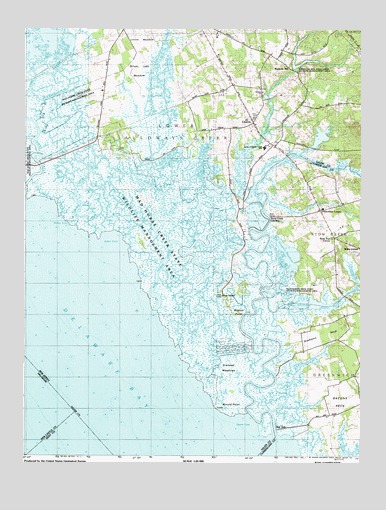
Canton, NJ USGS Topographic Map
Click on map above to begin viewing in our Map Viewer.

This topographic map contains these locations and features:
Feature Name Type Latitude Longitude GNIS ID View Map
Alder CoveBayN39.4359°W75.4683°874277View Map
Arnold PointCapeN39.3887°W75.4224°874383View Map
Bacons NeckCapeN39.3909°W75.3827°874455View Map
Bacons Neck SchoolSchoolN39.3951°W75.3752°874456View Map
Bay SidePopulated PlaceN39.3826°W75.4066°874551View Map
Bucks DitchCanalN39.4437°W75.4705°875007View Map
CantonPopulated PlaceN39.4709°W75.4149°875182View Map
Canton DrainStreamN39.4504°W75.4113°875183View Map
Canton SchoolSchoolN39.4768°W75.4196°875184View Map
Cat GutGutN39.4437°W75.4583°875236View Map
Cherry Tree CreekStreamN39.4007°W75.4391°875398View Map
Denn BranchStreamN39.4484°W75.4099°875892View Map
Devils GutGutN39.4640°W75.4755°875901View Map
Fishing CreekStreamN39.4423°W75.4839°876356View Map
Garrison CornerPopulated PlaceN39.4459°W75.3902°876564View Map
Goose PondLakeN39.4473°W75.4783°876676View Map
Grandad MeadowsSwampN39.3984°W75.4235°876704View Map
Gum Tree CornerPopulated PlaceN39.4376°W75.3849°876849View Map
HarmersvillePopulated PlaceN39.4990°W75.4344°876953View Map
Hidden Acres Farm AirportAirportN39.4322°W75.3910°2443717View Map
Little CreekStreamN39.4350°W75.4411°877828View Map
Locust MeadowFlatN39.4962°W75.4566°877889View Map
Long PondLakeN39.4571°W75.4760°882292View Map
Lower Alloways Creek Elementary SchoolSchoolN39.4642°W75.4111°2373770View Map
Lower Alloways Creek Fire and Rescue Company Station 2BuildingN39.4733°W75.4143°2614054View Map
Lower Deep CreekGutN39.4107°W75.4363°877963View Map
Mad Horse CreekStreamN39.4165°W75.4519°878016View Map
Mad Horse Creek Fish and Wildlife Management AreaParkN39.4251°W75.4413°884394View Map
Malapartis CreekStreamN39.4347°W75.4419°878048View Map
Maskells MillPopulated PlaceN39.4865°W75.4010°878173View Map
Maskells MillpondReservoirN39.4887°W75.3961°883048View Map
Maskells Millpond DamDamN39.4868°W75.4010°883895View Map
Maskells Millpond Fish and Wildlife Management AreaParkN39.4862°W75.3996°883047View Map
Muddy CreekStreamN39.3895°W75.4291°878641View Map
Newport MeadowsLakeN39.4332°W75.4013°878786View Map
Newport Meadows Seaplane BaseAirportN39.4334°W75.4019°884693View Map
Oyster CoveBayN39.3832°W75.4185°879066View Map
Pattys ForkStreamN39.4560°W75.4636°879168View Map
Phillips CreekStreamN39.3880°W75.4084°882291View Map
Pine IslandPopulated PlaceN39.4204°W75.4252°879305View Map
Raccoon DitchCanalN39.4182°W75.3888°879577View Map
Shore DitchCanalN39.4487°W75.4877°880577View Map
Silver Lake ForkGutN39.4529°W75.4530°880611View Map
Silver Lake MeadowFlatN39.4840°W75.4583°880612View Map
Solters CreekStreamN39.4801°W75.4982°880683View Map
Stathems NeckCapeN39.4096°W75.3888°880862View Map
Stoe Creek Farm AirportAirportN39.4804°W75.4063°2443710View Map
Stony InletBayN39.4409°W75.4863°880946View Map
Stow CreekStreamN39.3804°W75.4069°880957View Map
Stow Creek LandingPopulated PlaceN39.4426°W75.4085°880958View Map
Stretch PointCapeN39.4143°W75.4202°880974View Map
Taildragger Acres AirportAirportN39.4915°W75.4327°2770226View Map
Terrapin GutGutN39.4479°W75.4388°881139View Map
Township of Lower Alloways CreekCivilN39.4555°W75.4618°882065View Map
Turner ForkStreamN39.4459°W75.4479°881296View Map
Upper Deep CreekGutN39.4262°W75.4485°881383View Map
Willis CornerPopulated PlaceN39.4348°W75.3758°881848View Map

Note: Coordinates in the location and feature list above are referenced to NAD83 datum.


Copyright (C) 2008-2025 Ryan Niemi / Sunset Dynamics ... All Rights Reserved