TopoQuest Logo
Do you find TopoQuest useful?
Help keep TopoQuest running and adding new maps/features by donating!
Bitcoin:  19c7KJd3qBynnjoSw5npx9KScwjBe4ifkT
Litecoin:  LXs6TkuXGGXo1vDsWCkWVdjQX94eUKd6ui
Home View Maps Find Maps Find Places Resources & Links


Snowflake, Arizona Topographic Map

USGS Map Title: Snowflake, AZ
USGS Map MRC: 34110E1
DRG (GeoTIFF) Download: o34110e1.tif


Neighboring USGS Topographic Map Quads:


  Flattop Hill, AZ  
34110F2
 

  Tenmile Cedars, AZ  
34110F1
 

  Hay Hollow, AZ  
34109F8
 

  Second Knolls, AZ  
34110E2
 

  Snowflake, AZ  
34110E1
 

  Point of the Mountain, AZ  
34109E8
 

  Cactus Flat, AZ  
34110D2
 

  Taylor, AZ  
34110D1
 

  Mesa Redonda NW, AZ  
34109D8


Map MRC Location:

N35°
W111°
N35°
W110°
H8 H7 H6 H5 H4 H3 H2 H1
G8 G7 G6 G5 G4 G3 G2 G1
F8 F7 F6 F5 F4 F3 F2 F1
E8 E7 E6 E5 E4 E3 E2 E1
D8 D7 D6 D5 D4 D3 D2 D1
C8 C7 C6 C5 C4 C3 C2 C1
B8 B7 B6 B5 B4 B3 B2 B1
A8 A7 A6 A5 A4 A3 A2 A1
N34°
W111°
N34°
W110°

Snowflake, AZ USGS 1:24K Topographic Map Preview:
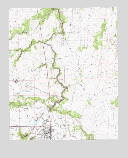
Snowflake, AZ USGS Topographic Map
Click on map above to begin viewing in our Map Viewer.

This topographic map contains these locations and features:
Feature Name Type Latitude Longitude GNIS ID View Map
Carriage House on West Garden Lane Assisted Living CenterBuildingN34.5148°W110.1195°2669697View Map
Concho FlatFlatN34.5367°W110.0209°3157View Map
Concho Flat WashStreamN34.5484°W110.0601°3158View Map
Cottonwood WashStreamN34.5250°W110.0784°28056View Map
East Snowflake DitchCanalN34.5064°W110.0609°28785View Map
Fivemile DrawValleyN34.5917°W110.0832°4647View Map
Fourmile DrawValleyN34.5775°W110.0729°4785View Map
Fourmile KnollSummitN34.5553°W110.1171°4786View Map
Highland Primary SchoolSchoolN34.5002°W110.0847°2543726View Map
Lower TankReservoirN34.5791°W110.0585°7512View Map
North WellWellN34.5570°W110.0054°8802View Map
Partnership WellWellN34.5986°W110.0023°9233View Map
Pin Head KnollSummitN34.5039°W110.1079°9446View Map
Point LookoutSummitN34.6125°W110.0843°9603View Map
Red HillSummitN34.5220°W110.0932°10048View Map
Riley TankReservoirN34.5769°W110.0683°10280View Map
Sevenmile DamDamN34.6025°W110.1043°11112View Map
Sevenmile DrawValleyN34.6239°W110.0732°11113View Map
Silver Creek Community Bible ChurchChurchN34.5049°W110.0770°2671792View Map
Sixmile DrawValleyN34.5850°W110.1107°11379View Map
SnowflakePopulated PlaceN34.5134°W110.0784°34591View Map
Snowflake - Taylor Police DepartmentBuildingN34.5048°W110.0791°2672306View Map
Snowflake - Taylor Public LibraryBuildingN34.5029°W110.0863°2669481View Map
Snowflake Elementary SchoolSchoolN34.5073°W110.0812°23437View Map
Snowflake Fire DepartmentBuildingN34.5034°W110.0845°2672377View Map
Snowflake High SchoolSchoolN34.5064°W110.0830°13042View Map
Snowflake Intermediate SchoolSchoolN34.5070°W110.0801°2543689View Map
Snowflake Municipal Airport (historical)AirportN34.5464°W110.1101°23438View Map
Snowflake Municipal Golf CourseLocaleN34.5087°W110.1220°2670480View Map
The Box of SevenmileLocaleN34.6245°W110.0740°11108View Map
The CanalStreamN34.5253°W110.0768°35213View Map
The Church of Jesus Christ of Latter Day SaintsChurchN34.5149°W110.0783°2671900View Map
The Church of Jesus Christ of Latter Day SaintsChurchN34.5099°W110.0797°2671908View Map
Town of SnowflakeCivilN34.5223°W110.0914°2413301View Map
Town of Snowflake Wastewater Treatment PlantLocaleN34.5158°W110.0872°2669628View Map
Upper TankReservoirN34.5677°W110.0594°13125View Map
Valley View Southern Baptist ChurchChurchN34.5148°W110.0782°2671428View Map
West Snowflake DitchCanalN34.5206°W110.0873°36018View Map

Note: Coordinates in the location and feature list above are referenced to NAD83 datum.


Copyright (C) 2008-2025 Ryan Niemi / Sunset Dynamics ... All Rights Reserved