TopoQuest Logo
Do you find TopoQuest useful?
Help keep TopoQuest running and adding new maps/features by donating!
Bitcoin:  19c7KJd3qBynnjoSw5npx9KScwjBe4ifkT
Litecoin:  LXs6TkuXGGXo1vDsWCkWVdjQX94eUKd6ui
Home View Maps Find Maps Find Places Resources & Links


Somerville, Texas Topographic Map

USGS Map Title: Somerville, TX
USGS Map MRC: 30096C5
DRG (GeoTIFF) Download: o30096c5.tif


Neighboring USGS Topographic Map Quads:


  Frenstat, TX  
30096D6
 

  Lyons, TX  
30096D5
 

  Snook, TX  
30096D4
 

  Flag Pond, TX  
30096C6
 

  Somerville, TX  
30096C5
 

  Gay Hill, TX  
30096C4
 

  Carmine, TX  
30096B6
 

  Burton, TX  
30096B5
 

  Brenham, TX  
30096B4


Map MRC Location:

N31°
W97°
N31°
W96°
H8 H7 H6 H5 H4 H3 H2 H1
G8 G7 G6 G5 G4 G3 G2 G1
F8 F7 F6 F5 F4 F3 F2 F1
E8 E7 E6 E5 E4 E3 E2 E1
D8 D7 D6 D5 D4 D3 D2 D1
C8 C7 C6 C5 C4 C3 C2 C1
B8 B7 B6 B5 B4 B3 B2 B1
A8 A7 A6 A5 A4 A3 A2 A1
N30°
W97°
N30°
W96°

Somerville, TX USGS 1:24K Topographic Map Preview:
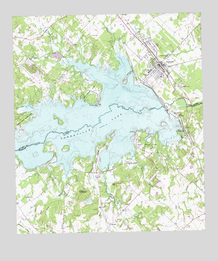
Somerville, TX USGS Topographic Map
Click on map above to begin viewing in our Map Viewer.

This topographic map contains these locations and features:
Feature Name Type Latitude Longitude GNIS ID View Map
Big CreekPopulated PlaceN30.3385°W96.5958°2034942View Map
Big CreekStreamN30.3480°W96.5872°1372539View Map
Big Creek ParkParkN30.3283°W96.5747°2028788View Map
Birch CreekStreamN30.3230°W96.6141°1372581View Map
Brushy CreekStreamN30.3524°W96.5575°1372766View Map
Burns CreekStreamN30.2835°W96.5914°1331704View Map
City of SomervilleCivilN30.3460°W96.5311°2411928View Map
Gay Hill Farm Airport (historical)AirportN30.2627°W96.5002°1386722View Map
Graveyard Crossing CemeteryCemeteryN30.3338°W96.5152°1336873View Map
Green MountainSummitN30.3160°W96.5166°1336934View Map
Hopewell ChurchChurchN30.2849°W96.5291°1338061View Map
Jerdelle CreekStreamN30.2894°W96.5630°1338714View Map
Johnsons Mountain LakeReservoirN30.2684°W96.5768°1854346View Map
Johnsons Mountain Lake DamDamN30.2685°W96.5752°1854345View Map
Little Big CreekStreamN30.3541°W96.5947°1374553View Map
Lucky Star Ranch AirportAirportN30.2909°W96.5280°2770648View Map
Medic 22BuildingN30.3448°W96.5284°2656203View Map
Mexican Cemetery Association CemeteryCemeteryN30.3583°W96.5511°1345854View Map
Mount Zion ChurchChurchN30.3035°W96.5111°1342140View Map
Oak Lawn CemeteryCemeteryN30.3616°W96.5450°1342995View Map
Old Rocky CreekStreamN30.2708°W96.5622°1343217View Map
Overlook ParkParkN30.3105°W96.5158°1343368View Map
QuarryPopulated PlaceN30.3077°W96.5105°2034875View Map
RehburgPopulated PlaceN30.2547°W96.5625°1378948View Map
Robbins LakeReservoirN30.2922°W96.5298°1865424View Map
Robbins Lake DamDamN30.2935°W96.5302°1865423View Map
Rocky Creek ParkParkN30.2988°W96.5683°1345473View Map
Rocky Creek Volunteer Fire DepartmentBuildingN30.2792°W96.5710°2552444View Map
Rocky ParkParkN30.3347°W96.5441°2029464View Map
Salty CreekStreamN30.2919°W96.5736°1346260View Map
Sandy BranchStreamN30.2941°W96.5469°1346581View Map
Schoppe CemeteryCemeteryN30.3635°W96.5725°1346785View Map
Shepherd MountainSummitN30.2738°W96.5819°1347026View Map
SomervillePopulated PlaceN30.3460°W96.5283°1347375View Map
Somerville City HallBuildingN30.3459°W96.5298°2753932View Map
Somerville DamDamN30.3264°W96.5286°1347376View Map
Somerville DivisionCivilN30.3652°W96.6024°1939204View Map
Somerville LakeReservoirN30.3255°W96.5275°1376179View Map
Somerville Police DepartmentBuildingN30.3459°W96.5299°2739299View Map
Somerville Post OfficePost OfficeN30.3450°W96.5300°2732100View Map
Sommerville Volunteer Fire DepartmentBuildingN30.3462°W96.5298°2552242View Map
Sweet Home ChurchChurchN30.3663°W96.5391°1348130View Map
Sweet Water CreekStreamN30.3252°W96.5166°1348134View Map
Welch ParkParkN30.3416°W96.5447°1349620View Map
Williams CemeteryCemeteryN30.3091°W96.5122°1350122View Map
Yegua Creek ParkParkN30.2988°W96.5364°1350662View Map
Yegua Creek Park Nature TrailTrailN30.3066°W96.5394°2033049View Map
Zion Hill ChurchChurchN30.2710°W96.6172°1350758View Map

Note: Coordinates in the location and feature list above are referenced to NAD83 datum.


Copyright (C) 2008-2025 Ryan Niemi / Sunset Dynamics ... All Rights Reserved