TopoQuest Logo
Do you find TopoQuest useful?
Help keep TopoQuest running and adding new maps/features by donating!
Bitcoin:  19c7KJd3qBynnjoSw5npx9KScwjBe4ifkT
Litecoin:  LXs6TkuXGGXo1vDsWCkWVdjQX94eUKd6ui
Home View Maps Find Maps Find Places Resources & Links


South Harpswell, Maine Topographic Map

USGS Map Title: South Harpswell, ME
USGS Map MRC: 43070F1
DRG (GeoTIFF) Download: o43070f1.tif


Neighboring USGS Topographic Map Quads:


  Yarmouth, ME  
43070G2
 

  Freeport, ME  
43070G1
 

  Orrs Island, ME  
43069G8
 

  Portland East, ME  
43070F2
 

  South Harpswell, ME  
43070F1
 

  Bailey Island, ME  
43069F8
 

  Cape Elizabeth, ME  
43070E2


Map MRC Location:

N44°
W71°
N44°
W70°
H8 H7 H6 H5 H4 H3 H2 H1
G8 G7 G6 G5 G4 G3 G2 G1
F8 F7 F6 F5 F4 F3 F2 F1
E8 E7 E6 E5 E4 E3 E2 E1
D8 D7 D6 D5 D4 D3 D2 D1
C8 C7 C6 C5 C4 C3 C2 C1
B8 B7 B6 B5 B4 B3 B2 B1
A8 A7 A6 A5 A4 A3 A2 A1
N43°
W71°
N43°
W70°

South Harpswell, ME USGS 1:24K Topographic Map Preview:
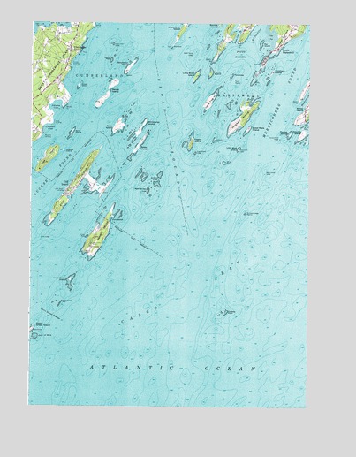
South Harpswell, ME USGS Topographic Map
Click on map above to begin viewing in our Map Viewer.

This topographic map contains these locations and features:
Feature Name Type Latitude Longitude GNIS ID View Map
Abner PointCapeN43.7248°W70.0045°561058View Map
Admiral Robert E Peary Home MuseumBuildingN43.7115°W70.0534°1912128View Map
Artist PointCapeN43.7490°W70.0981°561306View Map
Ash PointCapeN43.7440°W70.0325°561318View Map
Ash Point CoveBayN43.7492°W70.0225°561322View Map
Bangs IslandIslandN43.7279°W70.0909°561562View Map
Bar IslandIslandN43.7434°W70.0225°561572View Map
Basin PointCapeN43.7381°W70.0445°561689View Map
Basion Cove FallsFallsN43.7451°W70.0362°1913279View Map
Bates IslandIslandN43.7109°W70.0767°561720View Map
Birch Island LedgeBarN43.7392°W70.0545°562316View Map
Broad SoundBayN43.7173°W70.0650°563002View Map
Broken CoveBayN43.6990°W70.0689°563007View Map
Casco BayBayN43.6334°W70.0495°563660View Map
Central LandingPopulated PlaceN43.7362°W70.1075°579189View Map
Chebeague IslandPopulated PlaceN43.7409°W70.1081°563902View Map
Chebeague Island Fire DepartmentBuildingN43.7407°W70.1194°2552807View Map
Chebeague Island LibraryBuildingN43.7400°W70.1079°1912289View Map
Chebeague Island Post OfficePost OfficeN43.7295°W70.1113°1912290View Map
Chebeague Island Rescue SquadBuildingN43.7406°W70.1195°2666785View Map
Cliff IslandIslandN43.6987°W70.1039°564095View Map
Cliff IslandPopulated PlaceN43.6962°W70.1078°564096View Map
Cliff Island LandingPopulated PlaceN43.6951°W70.1100°579202View Map
Cliff Island LibraryBuildingN43.6986°W70.1058°2738490View Map
Cliff Island Post OfficePost OfficeN43.6949°W70.1088°1912311View Map
Cliff Island SchoolSchoolN43.6965°W70.1046°1912310View Map
Cocktail CoveBayN43.6862°W70.0917°1912314View Map
Coleman CoveBayN43.7154°W70.1178°564218View Map
Crow IslandIslandN43.7295°W70.1042°564595View Map
Drunker LedgeIslandN43.6881°W70.0287°1912368View Map
Drunkers Ledge BeaconLocaleN43.6881°W70.0289°565305View Map
Eagle IslandIslandN43.7112°W70.0539°565487View Map
Eagle Island LedgeBarN43.7076°W70.0523°565493View Map
Eastern Drunkers LedgeBarN43.6862°W70.0212°581730View Map
Fishermans CoveBayN43.6981°W70.0998°1912416View Map
Goose NestIslandN43.7381°W70.0903°566923View Map
Goose Nest LedgeBarN43.7431°W70.0895°566924View Map
Graveyard Point CemeteryCemeteryN43.7405°W70.0146°2736146View Map
Great Chebeague Golf ClubLocaleN43.7492°W70.1050°1912506View Map
Great Chebeague IslandIslandN43.7354°W70.1173°567130View Map
Great Harbor CoveBayN43.7248°W70.0256°567146View Map
Great Mark IslandIslandN43.7156°W70.0278°567159View Map
Green Island PassageChannelN43.6548°W70.1150°567235View Map
Green Island ReefBarN43.6587°W70.1112°567236View Map
Haddock RockIslandN43.7123°W70.0434°567413View Map
Halfway RockIslandN43.6559°W70.0370°567490View Map
Halfway Rock LightLocaleN43.6559°W70.0370°1912528View Map
Harpswell NeckCapeN43.7456°W70.0120°567666View Map
Haskell IslandIslandN43.7190°W70.0312°567735View Map
Hope IslandIslandN43.7059°W70.1175°568244View Map
Horse IslandIslandN43.7337°W70.0456°568279View Map
Indian RockBarN43.6804°W70.0998°568609View Map
Inner Green IslandIslandN43.6662°W70.1070°568644View Map
Jaquish GutGutN43.7181°W70.0006°568770View Map
Jaquish IslandIslandN43.7145°W70.0028°568771View Map
Jenks LandingPopulated PlaceN43.7173°W70.1153°579434View Map
Jewell IslandIslandN43.6820°W70.0925°568820View Map
Johns LedgeBarN43.6798°W70.1195°568900View Map
Johnson CoveBayN43.7173°W70.1153°568924View Map
Junk of PorkBarN43.6473°W70.1220°569033View Map
Little Birch IslandIslandN43.7326°W70.0528°569684View Map
Little Jewell IslandIslandN43.6879°W70.0923°1912658View Map
Little Mark IslandIslandN43.7087°W70.0325°569893View Map
Lobstermans StatueParkN43.7179°W70.0025°1912660View Map
Mackerel CoveBayN43.7262°W70.0012°570630View Map
Mark Island LedgeBarN43.7012°W70.0200°570783View Map
Merriconeag SoundBayN43.7276°W70.0125°571145View Map
Ministerial IslandIslandN43.7165°W70.0762°571423View Map
Mink RocksBarN43.7004°W70.0756°571438View Map
Monument LightLocaleN43.7093°W70.0320°571534View Map
Northwest LedgeBarN43.7298°W70.0328°581845View Map
Outer Green IslandIslandN43.6504°W70.1231°572862View Map
Pinkham IslandIslandN43.7343°W70.0170°573428View Map
Potts HarborBayN43.7401°W70.0323°573733View Map
Potts PointCapeN43.7309°W70.0262°573734View Map
PunchbowlBayN43.6868°W70.0864°573895View Map
Rogues IslandIslandN43.7084°W70.1103°574429View Map
Sand IslandIslandN43.7142°W70.1070°574840View Map
South HarpswellPopulated PlaceN43.7417°W70.0145°575849View Map
Stave IslandIslandN43.7159°W70.0875°576282View Map
Stave Island LedgeBarN43.7215°W70.0823°576287View Map
Stockman IslandIslandN43.7354°W70.0825°576370View Map
ThrumcapIslandN43.7331°W70.0356°577067View Map
Torry RockBarN43.7306°W70.0325°577211View Map
Town of Chebeague IslandCivilN43.7097°W70.0835°2364069View Map
Town of Long IslandCivilN43.6377°W70.1123°1729676View Map
Turnip IslandIslandN43.7140°W70.0089°577440View Map
Turnip Island LedgeBarN43.7123°W70.0137°577444View Map
Upper Flag IslandIslandN43.7245°W70.0464°577607View Map
Waldo PointCapeN43.7229°W70.1109°577780View Map
Webster RockBarN43.6587°W70.0370°581956View Map
West Brown CowIslandN43.6956°W70.0731°578112View Map
Western LandingPopulated PlaceN43.7140°W70.1195°579829View Map
Whale RockIslandN43.7048°W70.0389°578288View Map

Note: Coordinates in the location and feature list above are referenced to NAD83 datum.


Copyright (C) 2008-2024 Ryan Niemi / Sunset Dynamics ... All Rights Reserved