TopoQuest Logo
Do you find TopoQuest useful?
Help keep TopoQuest running and adding new maps/features by donating!
Bitcoin:  19c7KJd3qBynnjoSw5npx9KScwjBe4ifkT
Litecoin:  LXs6TkuXGGXo1vDsWCkWVdjQX94eUKd6ui
Home View Maps Find Maps Find Places Resources & Links


Orrs Island, Maine Topographic Map

USGS Map Title: Orrs Island, ME
USGS Map MRC: 43069G8
DRG (GeoTIFF) Download: o43069g8.tif


Neighboring USGS Topographic Map Quads:


  Lisbon Falls South, ME  
43070H1
 

  Brunswick, ME  
43069H8
 

  Bath, ME  
43069H7
 

  Freeport, ME  
43070G1
 

  Orrs Island, ME  
43069G8
 

  Phippsburg, ME  
43069G7
 

  South Harpswell, ME  
43070F1
 

  Bailey Island, ME  
43069F8
 

  Small Point, ME  
43069F7


Map MRC Location:

N44°
W70°
N44°
W69°
H8 H7 H6 H5 H4 H3 H2 H1
G8 G7 G6 G5 G4 G3 G2 G1
F8 F7 F6 F5 F4 F3 F2 F1
E8 E7 E6 E5 E4 E3 E2 E1
D8 D7 D6 D5 D4 D3 D2 D1
C8 C7 C6 C5 C4 C3 C2 C1
B8 B7 B6 B5 B4 B3 B2 B1
A8 A7 A6 A5 A4 A3 A2 A1
N43°
W70°
N43°
W69°

Orrs Island, ME USGS 1:24K Topographic Map Preview:
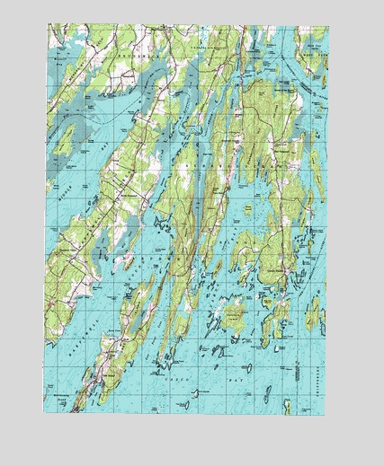
Orrs Island, ME USGS Topographic Map
Click on map above to begin viewing in our Map Viewer.

This topographic map contains these locations and features:
Feature Name Type Latitude Longitude GNIS ID View Map
Ballaststone LedgesBarN43.7717°W69.9225°561553View Map
Barnes PointCapeN43.8462°W69.9595°561626View Map
Beals CoveBayN43.7640°W69.9778°561770View Map
Bear IslandIslandN43.7820°W69.8809°561838View Map
Ben IslandIslandN43.8198°W69.9039°562040View Map
Bethel PointCapeN43.7956°W69.9100°562103View Map
Big Hen IslandIslandN43.7862°W69.9006°562175View Map
Bombazine IslandIslandN43.8606°W69.8973°562722View Map
Bragdon IslandIslandN43.8492°W69.8778°562874View Map
Brickyard CoveBayN43.8295°W69.9053°562949View Map
Bush IslandIslandN43.7876°W69.9106°563286View Map
Buttermilk CoveBayN43.8665°W69.9145°563314View Map
Buttermilk MountainSummitN43.8679°W69.9242°563315View Map
Buttermilk PointCapeN43.8601°W69.9125°563316View Map
Card CoveBayN43.7942°W69.9312°563502View Map
Cedar LedgesBarN43.7954°W69.8853°563726View Map
Center IslandIslandN43.8117°W69.9162°563755View Map
Clark CoveBayN43.7873°W69.9823°564030View Map
Clark LedgeBarN43.7829°W69.9789°581702View Map
Cox LedgeBarN43.7529°W69.9898°564435View Map
Cranberryhorn CemeteryCemeteryN43.8367°W69.8984°564486View Map
Cranberryhorn HillSummitN43.8365°W69.9070°564487View Map
Crow IslandIslandN43.8484°W69.9820°564598View Map
Cundy HarborBayN43.7923°W69.8900°580771View Map
Cundy LedgeBenchN43.7834°W69.8912°578929View Map
Cundy PointsCapeN43.7834°W69.8912°581986View Map
Cundys HarborPopulated PlaceN43.7970°W69.8931°581405View Map
Cundys Harbor Fire DepartmentBuildingN43.7980°W69.8938°2553052View Map
Cundys Harbor LibraryBuildingN43.7909°W69.8928°2738424View Map
Dingley CoveBayN43.8084°W69.8839°565113View Map
Dingley IslandIslandN43.8162°W69.8839°565114View Map
Dipper CoveBayN43.7873°W69.9623°565121View Map
Dipper Cove LedgesBarN43.7873°W69.9673°565122View Map
Dogs HeadIslandN43.7970°W69.9517°565178View Map
Doughty CoveBayN43.8523°W69.9164°565236View Map
Doughty PointCapeN43.8404°W69.9342°565238View Map
Duck RockIslandN43.7690°W69.9212°565365View Map
Dunning Private CemeteryCemeteryN43.8165°W69.9550°2740662View Map
Dyer CornerPopulated PlaceN43.8740°W69.9475°579263View Map
Dyer CoveBayN43.8331°W69.9253°565458View Map
Dyer CovePopulated PlaceN43.8212°W69.9206°565460View Map
East Cundy PointCapeN43.7751°W69.8945°565596View Map
East HarpswellPopulated PlaceN43.8337°W69.8984°565617View Map
East Harpswell Free Will Baptist ChurchChurchN43.7962°W69.8937°1912380View Map
Elm IslandsIslandN43.7570°W69.9317°565867View Map
Elm LedgeBarN43.7534°W69.9300°581734View Map
Ewin NarrowsChannelN43.8215°W69.9500°565978View Map
Fales HillSummitN43.8215°W69.9261°566015View Map
Flag IslandIslandN43.7518°W69.8912°566267View Map
Flag Island LedgeBarN43.7515°W69.8853°566268View Map
Flash IslandIslandN43.7737°W69.9109°566281View Map
Fort PointCapeN43.7795°W69.8917°566422View Map
Foster PointCapeN43.8584°W69.8812°566459View Map
George IslandIslandN43.7884°W69.9056°566741View Map
Goudy LedgeBarN43.7648°W69.8920°566984View Map
Green LedgesBarN43.7987°W69.8848°567246View Map
Gumet (historical)Populated PlaceN43.8623°W69.9134°1912521View Map
Gun PointCapeN43.7670°W69.9489°567394View Map
Gun Point CoveBayN43.7762°W69.9492°567395View Map
Gun Point School (historical)SchoolN43.7884°W69.9356°1912520View Map
Gurnet BridgeBridgeN43.8584°W69.9136°1912522View Map
Gurnet StraitChannelN43.8587°W69.9073°579079View Map
Harpswell CenterPopulated PlaceN43.8017°W69.9842°567662View Map
Harpswell Center CemeteryCemeteryN43.7999°W69.9873°2736156View Map
Harpswell CoveBayN43.8526°W69.9359°567663View Map
Harpswell Historical Society BuildingBuildingN43.7998°W69.9850°1912539View Map
Harpswell Islands SchoolSchoolN43.8376°W69.9150°567665View Map
Harpswell MeetinghouseChurchN43.7998°W69.9850°1912540View Map
Harpswell NeckCapeN43.8187°W69.9700°567667View Map
Harpswell Post OfficePost OfficeN43.7819°W69.9992°1912736View Map
Harpswell Sheriffs Deputy OfficeBuildingN43.8139°W69.9431°2735888View Map
Harpswell SoundBayN43.7826°W69.9742°567668View Map
Harpswell Town OfficesBuildingN43.8126°W69.9420°1912541View Map
Hen CoveBayN43.7948°W69.9067°567926View Map
Hen IslandIslandN43.7656°W69.9462°567927View Map
Hen IslandIslandN43.7901°W69.8964°567928View Map
High HeadCapeN43.7981°W69.9620°580270View Map
High Head Yacht ClubLocaleN43.8009°W69.9592°1912556View Map
Hillcrest CemeteryCemeteryN43.7985°W69.9826°2736161View Map
Holbrooks MarinaLocaleN43.7884°W69.8912°1912568View Map
Hopkins IslandIslandN43.8042°W69.8875°568253View Map
Indian PointCapeN43.8565°W69.8906°568590View Map
Iron IslandIslandN43.8665°W69.9009°568673View Map
Jenny IslandIslandN43.7651°W69.9081°568798View Map
Jenny LedgeBarN43.7559°W69.9100°568799View Map
Jordan PointCapeN43.8406°W69.9628°568993View Map
Leavitt IslandIslandN43.7906°W69.8987°569431View Map
Little Birch IslandIslandN43.8290°W69.9914°569685View Map
Little Iron IslandIslandN43.8337°W69.9850°569847View Map
Little IslandIslandN43.7948°W69.8887°569848View Map
Lombos HoleBayN43.7998°W69.9437°570166View Map
Long CoveBayN43.7845°W69.9539°570184View Map
Long IslandIslandN43.8284°W69.8800°570212View Map
Long LedgeIslandN43.7568°W69.9000°570246View Map
Long Point IslandIslandN43.7665°W69.9434°570271View Map
Long ReachBayN43.8298°W69.9309°570314View Map
Long Reach MountainSummitN43.8099°W69.9361°570315View Map
Lookout PointCapeN43.8087°W69.9931°570356View Map
Lowell CoveBayN43.7551°W69.9770°570464View Map
Lower Coombs IslandIslandN43.8626°W69.9059°570482View Map
Malaga IslandIslandN43.7818°W69.8750°570684View Map
Mare BrookStreamN43.8634°W69.9317°570766View Map
Merepoint NeckCapeN43.8640°W69.9814°571144View Map
Merriman CoveBayN43.7901°W69.9767°571172View Map
Merriman LedgesBarN43.7745°W69.9859°581823View Map
Middle BayBayN43.8276°W69.9831°571209View Map
Middle Bay CoveBayN43.8590°W69.9525°571210View Map
Middle RockBarN43.7695°W69.9539°581827View Map
Mill CoveBayN43.8056°W69.9625°571318View Map
Miller CreekStreamN43.8526°W69.9842°571371View Map
Miller PointCapeN43.8526°W69.9825°571375View Map
Misery HillSummitN43.8456°W69.9164°571451View Map
New Meadows RiverStreamN43.7715°W69.8870°572121View Map
North HarpswellPopulated PlaceN43.8209°W69.9664°572345View Map
North Jenny LedgeBarN43.7656°W69.9034°581840View Map
North LedgeBarN43.8040°W69.9198°572357View Map
Oak IslandIslandN43.7629°W69.9489°572609View Map
Oak LedgeRidgeN43.8487°W69.8975°572619View Map
Oak Ledge CampLocaleN43.8554°W69.8903°572620View Map
Orr`s Island LibraryBuildingN43.7613°W69.9759°2738409View Map
Orrs CoveBayN43.8298°W69.9148°572781View Map
Orrs HillSummitN43.8526°W69.9062°572782View Map
Orrs IslandIslandN43.7726°W69.9620°581473View Map
Orrs IslandPopulated PlaceN43.7606°W69.9762°581474View Map
Orrs Island CampgroundLocaleN43.7706°W69.9723°1912831View Map
Orrs Island CemeteryCemeteryN43.7682°W69.9711°2740746View Map
Orrs Island Fire StationBuildingN43.7677°W69.9720°2553017View Map
Orrs Island Post OfficePost OfficeN43.7599°W69.9781°1912832View Map
Orrs-Bailey Yacht ClubLocaleN43.7512°W69.9870°1912833View Map
Pennell CemeteryCemeteryN43.8691°W69.9646°2736196View Map
PennellvillePopulated PlaceN43.8604°W69.9614°579612View Map
Pennellville Historic DistrictParkN43.8601°W69.9609°1912863View Map
Pinkham PointCapeN43.7951°W69.9287°573431View Map
Pole IslandIslandN43.7967°W69.9231°573572View Map
Prince GurnetChannelN43.8376°W69.9370°573822View Map
Prince PointCapeN43.8404°W69.9373°581484View Map
Quahog BayBayN43.7995°W69.9187°573913View Map
Queen of the Mission ChapelChurchN43.8540°W69.8892°573934View Map
Reed CoveBayN43.7767°W69.9687°574121View Map
Rich CoveBayN43.8265°W69.9020°574162View Map
Ridley CoveBayN43.7795°W69.9053°574206View Map
Rogue IslandIslandN43.7715°W69.8962°574427View Map
Sandy CoveBayN43.7787°W69.8937°574876View Map
Sebascodegan IslandIslandN43.8267°W69.9092°581370View Map
Serag IslandIslandN43.8376°W69.9817°575237View Map
Sheep IslandIslandN43.8040°W69.8825°575337View Map
Sheep Island LedgeBarN43.8006°W69.8789°575354View Map
Sheep Island North LedgesBarN43.8090°W69.8812°575356View Map
Simpson PointCapeN43.8520°W69.9728°575484View Map
Skolfield CemeteryCemeteryN43.8602°W69.9439°2736247View Map
Skolfield CoveBayN43.8529°W69.9409°575528View Map
Skolfield Doyle CemeteryCemeteryN43.8696°W69.9360°2736248View Map
Snow IslandIslandN43.8162°W69.9095°575680View Map
South LedgesBarN43.7904°W69.9259°575861View Map
Stoop LedgesBarN43.7548°W69.9517°581925View Map
Stover PointCapeN43.7579°W69.9981°576422View Map
Strawberry CreekStreamN43.8090°W69.9467°576434View Map
The DockBayN43.7567°W69.9784°576793View Map
Three IslandsIslandN43.8456°W69.8814°577056View Map
Tondreaus PointCapeN43.8242°W69.9139°577192View Map
Two Bush IslandIslandN43.7529°W69.9359°577498View Map
Uncle Zeke IslandIslandN43.8026°W69.9512°577534View Map
Union ChurchChurchN43.7687°W69.9709°577546View Map
Upper Coombs IslandIslandN43.8662°W69.9042°577584View Map
Watsons MarinaLocaleN43.7923°W69.8925°1913271View Map
West Cundy PointCapeN43.7726°W69.9017°578127View Map
Wharton PointCapeN43.8681°W69.9928°578305View Map
White IslandIslandN43.8373°W69.9909°578357View Map
Widgeon CoveBayN43.8037°W69.9742°578447View Map
Williams IslandIslandN43.8609°W69.8764°578517View Map
Wilson CoveBayN43.8173°W69.9789°578541View Map
Wilson LedgesBarN43.8226°W69.9814°578549View Map
Wilson PondReservoirN43.7702°W69.9672°1774307View Map
Wilson Pond DamDamN43.7785°W69.9426°1774306View Map
Woodward CoveBayN43.8715°W69.9073°578694View Map
Wyer IslandIslandN43.7909°W69.9614°578720View Map
Yarmouth IslandIslandN43.7815°W69.9156°578740View Map
Yarmouth LedgesBarN43.7715°W69.9300°578741View Map

Note: Coordinates in the location and feature list above are referenced to NAD83 datum.


Copyright (C) 2008-2024 Ryan Niemi / Sunset Dynamics ... All Rights Reserved