TopoQuest Logo
Do you find TopoQuest useful?
Help keep TopoQuest running and adding new maps/features by donating!
Bitcoin:  19c7KJd3qBynnjoSw5npx9KScwjBe4ifkT
Litecoin:  LXs6TkuXGGXo1vDsWCkWVdjQX94eUKd6ui
Home View Maps Find Maps Find Places Resources & Links


South Mills, North Carolina Topographic Map

USGS Map Title: South Mills, NC
USGS Map MRC: 36076D3
DRG (GeoTIFF) Download: o36076d3.tif


Neighboring USGS Topographic Map Quads:


  Moyock, NC  
36076E2
 

  Lynchs Corner, NC  
36076D4
 

  South Mills, NC  
36076D3
 

  Lambs Corner, NC  
36076D2
 

  Chapanoke, NC  
36076C4
 

  Pasquotank, NC  
36076C3
 

  Elizabeth City, NC  
36076C2


Map MRC Location:

N37°
W77°
N37°
W76°
H8 H7 H6 H5 H4 H3 H2 H1
G8 G7 G6 G5 G4 G3 G2 G1
F8 F7 F6 F5 F4 F3 F2 F1
E8 E7 E6 E5 E4 E3 E2 E1
D8 D7 D6 D5 D4 D3 D2 D1
C8 C7 C6 C5 C4 C3 C2 C1
B8 B7 B6 B5 B4 B3 B2 B1
A8 A7 A6 A5 A4 A3 A2 A1
N36°
W77°
N36°
W76°

South Mills, NC USGS 1:24K Topographic Map Preview:
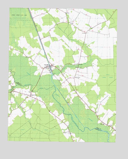
South Mills, NC USGS Topographic Map
Click on map above to begin viewing in our Map Viewer.

This topographic map contains these locations and features:
Feature Name Type Latitude Longitude GNIS ID View Map
Antioch ChurchChurchN36.4324°W76.3161°1002706View Map
Bethel ChurchChurchN36.4257°W76.3702°1003270View Map
Burnt MillsPopulated PlaceN36.3943°W76.2649°1019427View Map
Cartwright PitMineN36.4100°W76.3244°2648434View Map
Ebenezer ChurchChurchN36.4457°W76.3263°1002704View Map
Fauna (historical)Populated PlaceN36.3849°W76.3030°1018697View Map
Geneva ChurchChurchN36.3904°W76.2552°1003787View Map
Jackson CornerPopulated PlaceN36.4215°W76.3677°1003207View Map
Joes Island CreekStreamN36.3857°W76.2649°1003216View Map
Johnsons CornerPopulated PlaceN36.4346°W76.2985°1020967View Map
Joyce CreekStreamN36.4377°W76.3247°987793View Map
Lebanon Mobile Home ParkPopulated PlaceN36.4294°W76.3694°2505487View Map
LillyPopulated PlaceN36.4854°W76.3027°988484View Map
Lock Number 2DamN36.4395°W76.3241°1026283View Map
McBride ChurchChurchN36.4449°W76.2947°1002705View Map
Memory GardensCemeteryN36.3843°W76.3041°1003269View Map
Mill Pond CreekStreamN36.4229°W76.3719°1003194View Map
Morgans CornersPopulated PlaceN36.4174°W76.3491°990239View Map
Newland ChurchChurchN36.4229°W76.3691°1003271View Map
Oak Grove ChurchChurchN36.4235°W76.2974°1002707View Map
PiercevillePopulated PlaceN36.4485°W76.2935°1021888View Map
SharonPopulated PlaceN36.4957°W76.3097°1022561View Map
Smithson LandingLocaleN36.3846°W76.2585°1002702View Map
South MillsPopulated PlaceN36.4457°W76.3274°1025718View Map
South Mills Census Designated PlaceCensusN36.4379°W76.3307°2628656View Map
South Mills Post OfficePost OfficeN36.4453°W76.3289°2505393View Map
South Mills Volunteer Fire DepartmentBuildingN36.4455°W76.3315°2638558View Map
Tar CornerPopulated PlaceN36.4771°W76.2860°1022881View Map
Township of South MillsCivilN36.4802°W76.3405°1026497View Map
Trinity ChurchChurchN36.4465°W76.3249°1002703View Map
Turners CutCanalN36.4102°W76.3047°996366View Map

Note: Coordinates in the location and feature list above are referenced to NAD83 datum.


Copyright (C) 2008-2024 Ryan Niemi / Sunset Dynamics ... All Rights Reserved