TopoQuest Logo
Do you find TopoQuest useful?
Help keep TopoQuest running and adding new maps/features by donating!
Bitcoin:  19c7KJd3qBynnjoSw5npx9KScwjBe4ifkT
Litecoin:  LXs6TkuXGGXo1vDsWCkWVdjQX94eUKd6ui
Home View Maps Find Maps Find Places Resources & Links


Sparks, Colorado Topographic Map

USGS Map Title: Sparks, CO
USGS Map MRC: 40108H7
DRG (GeoTIFF) Download: o40108h7.tif


Neighboring USGS Topographic Map Quads:


  Four J Rim, WY  
41108A8
 

  Scrivner Butte, WY  
41108A7
 

  Chicken Creek SW, WY  
41108A6
 

  Beaver Basin, CO  
40108H8
 

  Sparks, CO  
40108H7
 

  Sugarloaf Butte, CO  
40108H6
 

  Lodore School, CO  
40108G8
 

  Big Joe Basin, CO  
40108G7
 

  Irish Canyon, CO  
40108G6


Map MRC Location:

N41°
W109°
N41°
W108°
H8 H7 H6 H5 H4 H3 H2 H1
G8 G7 G6 G5 G4 G3 G2 G1
F8 F7 F6 F5 F4 F3 F2 F1
E8 E7 E6 E5 E4 E3 E2 E1
D8 D7 D6 D5 D4 D3 D2 D1
C8 C7 C6 C5 C4 C3 C2 C1
B8 B7 B6 B5 B4 B3 B2 B1
A8 A7 A6 A5 A4 A3 A2 A1
N40°
W109°
N40°
W108°

Sparks, CO USGS 1:24K Topographic Map Preview:
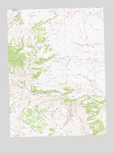
Sparks, CO USGS Topographic Map
Click on map above to begin viewing in our Map Viewer.

This topographic map contains these locations and features:
Feature Name Type Latitude Longitude GNIS ID View Map
Airborne Anomalous Area 57-10MineN40.9905°W108.8109°1683120View Map
Antone CanyonValleyN40.9144°W108.7722°169688View Map
Arthurs ReservoirReservoirN40.8792°W108.8376°169695View Map
Big DrawValleyN40.9139°W108.8061°169690View Map
Buck BasinBasinN40.8947°W108.8059°169689View Map
Buck DrawValleyN40.9141°W108.8074°169691View Map
Choke Cherry DrawValleyN40.9158°W108.8478°169692View Map
Cold Spring MountainSummitN40.8952°W108.8715°169694View Map
Coyote SpringSpringN40.8766°W108.8262°169697View Map
Diamond FieldFlatN40.9930°W108.8437°201847View Map
Diamond Field DrawValleyN40.9801°W108.8447°169679View Map
Elk RanchLocaleN40.9200°W108.8615°169685View Map
Fish ReservoirsReservoirN40.9375°W108.8737°169680View Map
Fonce FlatFlatN40.9808°W108.7637°201846View Map
Fondillos DrawValleyN40.9188°W108.8564°169693View Map
G FlatsFlatN40.9336°W108.7932°169684View Map
G MeadowsFlatN40.9508°W108.8084°169681View Map
Hanging Tree DrawValleyN40.9516°W108.7835°169682View Map
Harry Holy BottomBendN40.9105°W108.7971°169772View Map
Johnson FlatsFlatN40.9911°W108.8740°201848View Map
SparksLocaleN40.9180°W108.8171°169686View Map
Station RanchLocaleN40.9205°W108.7859°169687View Map
Sugarloaf CampLocaleN40.9486°W108.7612°169683View Map

Note: Coordinates in the location and feature list above are referenced to NAD83 datum.


Copyright (C) 2008-2024 Ryan Niemi / Sunset Dynamics ... All Rights Reserved