TopoQuest Logo
Do you find TopoQuest useful?
Help keep TopoQuest running and adding new maps/features by donating!
Bitcoin:  19c7KJd3qBynnjoSw5npx9KScwjBe4ifkT
Litecoin:  LXs6TkuXGGXo1vDsWCkWVdjQX94eUKd6ui
Home View Maps Find Maps Find Places Resources & Links


Sparrowhawk Point, New York Topographic Map

USGS Map Title: Sparrowhawk Point, NY
USGS Map MRC: 44075G3
DRG (GeoTIFF) Download: o44075g3.tif


Neighboring USGS Topographic Map Quads:


  Morrisburg, ON  
44075H2
 

  Red Mills, NY  
44075G4
 

  Sparrowhawk Point, NY  
44075G3
 

  Waddington, NY  
44075G2
 

  Ogdensburg East, NY  
44075F4
 

  Lisbon, NY  
44075F3
 

  Morley, NY  
44075F2


Map MRC Location:

N45°
W76°
N45°
W75°
H8 H7 H6 H5 H4 H3 H2 H1
G8 G7 G6 G5 G4 G3 G2 G1
F8 F7 F6 F5 F4 F3 F2 F1
E8 E7 E6 E5 E4 E3 E2 E1
D8 D7 D6 D5 D4 D3 D2 D1
C8 C7 C6 C5 C4 C3 C2 C1
B8 B7 B6 B5 B4 B3 B2 B1
A8 A7 A6 A5 A4 A3 A2 A1
N44°
W76°
N44°
W75°

Sparrowhawk Point, NY USGS 1:24K Topographic Map Preview:
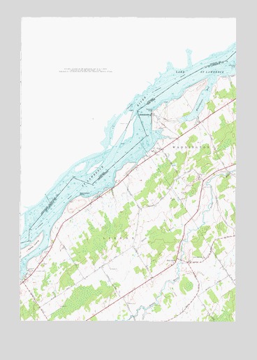
Sparrowhawk Point, NY USGS Topographic Map
Click on map above to begin viewing in our Map Viewer.

This topographic map contains these locations and features:
Feature Name Type Latitude Longitude GNIS ID View Map
Brown ChurchChurchN44.8212°W75.2935°976038View Map
Iroquois DamDamN44.8351°W75.3022°976481View Map
Iroquois Organic FarmLocaleN44.8161°W75.3036°2559374View Map
Keystone DairyLocaleN44.7736°W75.3003°2702620View Map
Leading LightLocaleN44.8023°W75.3316°975858View Map
Lisbon BeachBeachN44.7712°W75.3702°975860View Map
Livingston CemeteryCemeteryN44.7709°W75.3660°976578View Map
Lotus Island (historical)IslandN44.7847°W75.3644°2120531View Map
Martin CemeteryCemeteryN44.7574°W75.3128°976632View Map
Nevin Memorial ChurchChurchN44.7764°W75.2680°976715View Map
O'Brian FarmsLocaleN44.7539°W75.3306°2702698View Map
O'Neill CemeteryCemeteryN44.7778°W75.3610°976750View Map
Pine GrovePopulated PlaceN44.7742°W75.2852°976816View Map
Rockway PointCapeN44.8367°W75.2983°976904View Map
School Number 10 (historical)SchoolN44.7969°W75.3039°2120536View Map
School Number 11 (historical)SchoolN44.8081°W75.3161°2120537View Map
School Number 15 (historical)SchoolN44.7919°W75.3475°2120555View Map
School Number 17 (historical)SchoolN44.7739°W75.3253°2120556View Map
School Number 2 (historical)SchoolN44.8333°W75.2719°2120533View Map
School Number 24 (historical)SchoolN44.7611°W75.2722°2120557View Map
School Number 3 (historical)SchoolN44.7658°W75.3019°2120534View Map
School Number 3 (historical)SchoolN44.8119°W75.2614°2120535View Map
Sparrowhawk PointCapeN44.8017°W75.3397°977040View Map
Squaw CreekStreamN44.7876°W75.2763°977049View Map
Sucker Brook (historical)Populated PlaceN44.8133°W75.2567°2120532View Map
Union CemeteryCemeteryN44.8118°W75.2549°977162View Map
Whitehouse BayBayN44.8411°W75.2702°977270View Map

Note: Coordinates in the location and feature list above are referenced to NAD83 datum.


Copyright (C) 2008-2025 Ryan Niemi / Sunset Dynamics ... All Rights Reserved