TopoQuest Logo
Do you find TopoQuest useful?
Help keep TopoQuest running and adding new maps/features by donating!
Bitcoin:  19c7KJd3qBynnjoSw5npx9KScwjBe4ifkT
Litecoin:  LXs6TkuXGGXo1vDsWCkWVdjQX94eUKd6ui
Home View Maps Find Maps Find Places Resources & Links


Speedwell, Virginia Topographic Map

USGS Map Title: Speedwell, VA
USGS Map MRC: 36081G2
DRG (GeoTIFF) Download: o36081g2.tif


Neighboring USGS Topographic Map Quads:


  Rural Retreat, VA  
36081H3
 

  Crockett, VA  
36081H2
 

  Wytheville, VA  
36081H1
 

  Cedar Springs, VA  
36081G3
 

  Speedwell, VA  
36081G2
 

  Cripple Creek, VA  
36081G1
 

  Middle Fox Creek, VA  
36081F3
 

  Elk Creek, VA  
36081F2
 

  Brierpatch Mountain, VA  
36081F1


Map MRC Location:

N37°
W82°
N37°
W81°
H8 H7 H6 H5 H4 H3 H2 H1
G8 G7 G6 G5 G4 G3 G2 G1
F8 F7 F6 F5 F4 F3 F2 F1
E8 E7 E6 E5 E4 E3 E2 E1
D8 D7 D6 D5 D4 D3 D2 D1
C8 C7 C6 C5 C4 C3 C2 C1
B8 B7 B6 B5 B4 B3 B2 B1
A8 A7 A6 A5 A4 A3 A2 A1
N36°
W82°
N36°
W81°

Speedwell, VA USGS 1:24K Topographic Map Preview:
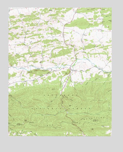
Speedwell, VA USGS Topographic Map
Click on map above to begin viewing in our Map Viewer.

This topographic map contains these locations and features:
Feature Name Type Latitude Longitude GNIS ID View Map
Andrews HollowValleyN36.8145°W81.1968°1481322View Map
Big BranchStreamN36.8171°W81.2179°1481701View Map
Bowen BranchStreamN36.8176°W81.2237°1481944View Map
Bowling Green MountainSummitN36.8129°W81.2159°1499154View Map
Cave HillSummitN36.8110°W81.1812°1499226View Map
Chaney BranchStreamN36.8254°W81.1537°1482446View Map
Claybank HollowValleyN36.8180°W81.1472°1482555View Map
CollierPopulated PlaceN36.8179°W81.2093°1499284View Map
Comers RockSummitN36.7643°W81.2282°1499293View Map
Comers Rock Recreation AreaParkN36.7635°W81.2234°1482673View Map
Divide TrailTrailN36.7718°W81.1293°1483031View Map
Dry RunStreamN36.8179°W81.1723°1483128View Map
Dry Run GapGapN36.7635°W81.1718°1483148View Map
East Dry Run ForkStreamN36.7757°W81.1806°1483201View Map
Edgewood School (historical)SchoolN36.8598°W81.1787°1501293View Map
Etter School (historical)SchoolN36.8707°W81.2490°1501294View Map
Flemming ChurchChurchN36.8368°W81.1448°1483459View Map
Flemming School (historical)SchoolN36.8415°W81.1479°1501301View Map
Harvey School (historical)SchoolN36.8040°W81.2279°1501312View Map
Henley HollowValleyN36.7883°W81.1836°1484039View Map
High KnobSummitN36.7568°W81.1498°1484081View Map
Horse HeavenSummitN36.7843°W81.1437°1484221View Map
Horse Heaven TrailTrailN36.7787°W81.1284°1484222View Map
Hungry Mother DamDamN36.8707°W81.2218°1490849View Map
Hussy Mountain Horse CampLocaleN36.7715°W81.1443°1488793View Map
Jackson HollowValleyN36.8103°W81.1748°1484388View Map
Lick Mountain ChurchChurchN36.8735°W81.1373°1484824View Map
Lick Mountain School (historical)SchoolN36.8737°W81.1376°1501339View Map
Little Dry RunStreamN36.7912°W81.1870°1484901View Map
Little Dry Run TrailTrailN36.7782°W81.2051°1488790View Map
Little Dry Run WildernessReserveN36.7850°W81.2120°1488791View Map
Perkins KnobSummitN36.7596°W81.1337°1486145View Map
Perkins Knob TrailTrailN36.7612°W81.1448°1488792View Map
Pool Spring BranchStreamN36.8137°W81.1368°1486336View Map
Porter MountainSummitN36.7793°W81.1765°1499901View Map
Rocky Hollow TrailTrailN36.8023°W81.1276°1488674View Map
Rosenbaum ChurchChurchN36.8535°W81.1376°1486773View Map
Rowe CrossroadsPopulated PlaceN36.8493°W81.1598°1499999View Map
Sand MountainSummitN36.8737°W81.1415°1500021View Map
SimmermanPopulated PlaceN36.8165°W81.1404°1500106View Map
Sindion PointSummitN36.7957°W81.1973°1500108View Map
SpeedwellPopulated PlaceN36.8137°W81.1718°1502808View Map
Speedwell DistrictCivilN36.8406°W81.1345°1927513View Map
Speedwell Elementary SchoolSchoolN36.8163°W81.1760°2085815View Map
Speedwell Methodist CemeteryCemeteryN36.8137°W81.1915°1502776View Map
Speedwell Methodist ChurchChurchN36.8137°W81.1915°1502809View Map
Speedwell Post OfficePost OfficeN36.8155°W81.1745°2780820View Map
Speedwell Volunteer Fire DepartmentBuildingN36.8193°W81.1747°2085845View Map
Stroupes StoreLocaleN36.8632°W81.1415°1487669View Map
Sugar RunStreamN36.8246°W81.1673°1487695View Map
Ward BranchStreamN36.8162°W81.2090°1488188View Map
West Dry Run ForkStreamN36.7757°W81.1804°1488247View Map
Wolfpen BranchStreamN36.7504°W81.2368°1488463View Map
Wyrick SpringSpringN36.8723°W81.1973°1487104View Map
Zion CemeteryCemeteryN36.8412°W81.2229°1501390View Map
Zion ChurchChurchN36.8412°W81.2223°1487133View Map
Zion School (historical)SchoolN36.8446°W81.2254°1501391View Map

Note: Coordinates in the location and feature list above are referenced to NAD83 datum.


Copyright (C) 2008-2025 Ryan Niemi / Sunset Dynamics ... All Rights Reserved