TopoQuest Logo
Do you find TopoQuest useful?
Help keep TopoQuest running and adding new maps/features by donating!
Bitcoin:  19c7KJd3qBynnjoSw5npx9KScwjBe4ifkT
Litecoin:  LXs6TkuXGGXo1vDsWCkWVdjQX94eUKd6ui
Home View Maps Find Maps Find Places Resources & Links


Cedar Springs, Virginia Topographic Map

USGS Map Title: Cedar Springs, VA
USGS Map MRC: 36081G3
DRG (GeoTIFF) Download: o36081g3.tif


Neighboring USGS Topographic Map Quads:


  Nebo, VA  
36081H4
 

  Rural Retreat, VA  
36081H3
 

  Crockett, VA  
36081H2
 

  Atkins, VA  
36081G4
 

  Cedar Springs, VA  
36081G3
 

  Speedwell, VA  
36081G2
 

  Trout Dale, VA  
36081F4
 

  Middle Fox Creek, VA  
36081F3
 

  Elk Creek, VA  
36081F2


Map MRC Location:

N37°
W82°
N37°
W81°
H8 H7 H6 H5 H4 H3 H2 H1
G8 G7 G6 G5 G4 G3 G2 G1
F8 F7 F6 F5 F4 F3 F2 F1
E8 E7 E6 E5 E4 E3 E2 E1
D8 D7 D6 D5 D4 D3 D2 D1
C8 C7 C6 C5 C4 C3 C2 C1
B8 B7 B6 B5 B4 B3 B2 B1
A8 A7 A6 A5 A4 A3 A2 A1
N36°
W82°
N36°
W81°

Cedar Springs, VA USGS 1:24K Topographic Map Preview:
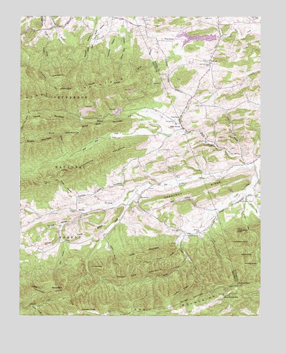
Cedar Springs, VA USGS Topographic Map
Click on map above to begin viewing in our Map Viewer.

This topographic map contains these locations and features:
Feature Name Type Latitude Longitude GNIS ID View Map
Asbury ChurchChurchN36.8229°W81.2784°1481344View Map
Asbury School (historical)SchoolN36.8148°W81.2576°1958864View Map
Ashland HollowValleyN36.7927°W81.3423°1481350View Map
Blue SpringSpringN36.7968°W81.3272°1481862View Map
Blue Spring ChurchChurchN36.7998°W81.3123°1481864View Map
Blue Spring CreekStreamN36.8118°W81.2565°1481865View Map
Blue Spring GapGapN36.7582°W81.2687°1481867View Map
Blue Spring School (historical)SchoolN36.7998°W81.3123°1956869View Map
Blue Spring School (historical)SchoolN36.7993°W81.3129°1500445View Map
Buchanan MountainSummitN36.8162°W81.3298°1492653View Map
Bullins BranchStreamN36.7848°W81.3279°1482161View Map
Buzzard RockSummitN36.7632°W81.2618°1492687View Map
CampLocaleN36.7840°W81.2890°1482241View Map
Canadays RidgeRidgeN36.7518°W81.3370°1482296View Map
Carmi CemeteryCemeteryN36.7854°W81.2920°1482326View Map
Carmi ChurchChurchN36.7835°W81.2868°1482327View Map
Cave RidgeRidgeN36.7854°W81.3351°1482383View Map
Cedar SpringSpringN36.8326°W81.2921°1482416View Map
Cedar SpringsPopulated PlaceN36.8282°W81.2904°1492736View Map
Chestnut RidgeRidgeN36.8015°W81.2848°1482493View Map
Cress LakeLakeN36.8071°W81.2726°1958865View Map
Crigger CreekStreamN36.8143°W81.2529°1482835View Map
Crigger Creek TrailTrailN36.7640°W81.3012°1488637View Map
Dark HollowValleyN36.7984°W81.2843°1482914View Map
Dry CreekStreamN36.8046°W81.3112°1483111View Map
FairviewPopulated PlaceN36.8568°W81.2762°1492926View Map
Fairview School (historical)SchoolN36.8557°W81.2782°1958863View Map
Glade MountainSummitN36.8412°W81.3598°1492999View Map
Glade Mountain ShelterLocaleN36.8515°W81.3657°1488786View Map
Granny BranchStreamN36.7837°W81.2915°1483741View Map
Gray BranchStreamN36.8168°W81.2601°1483773View Map
Groseclose ChapelChurchN36.7976°W81.2601°1483850View Map
Hale DamDamN36.7610°W81.2504°1489910View Map
Hale LakeReservoirN36.7613°W81.2507°1483890View Map
Harvel CreekStreamN36.7876°W81.2801°1483964View Map
Harvey KnobSummitN36.7748°W81.2604°1493060View Map
Heldreth HollowValleyN36.8667°W81.3227°1484017View Map
Horne KnobSummitN36.7701°W81.3315°1493107View Map
Huckleberry KnobSummitN36.7804°W81.2648°1493112View Map
Jones CreekStreamN36.7979°W81.2573°1484498View Map
Keesling CemeteryCemeteryN36.8312°W81.2945°1484529View Map
Killinger CreekStreamN36.8265°W81.2890°1484595View Map
Kinser CreekStreamN36.8029°W81.2576°1484612View Map
Kirk CemeteryCemeteryN36.7809°W81.3518°1484616View Map
Kirk HollowValleyN36.7810°W81.3526°1484617View Map
Laurel HollowValleyN36.8596°W81.3071°1484714View Map
Leading RidgeRidgeN36.7610°W81.2901°1484747View Map
Lindamood School (historical)SchoolN36.8704°W81.3582°1500491View Map
Little Huckleberry KnobSummitN36.7857°W81.2634°1493209View Map
Little MountainSummitN36.7771°W81.3076°1493211View Map
Little MountainSummitN36.8498°W81.3554°1493213View Map
Little MountainSummitN36.7640°W81.3609°1493555View Map
Locust MountainSummitN36.8312°W81.3701°1493219View Map
Middle CreekStreamN36.7748°W81.2876°1485363View Map
Panther KnobSummitN36.7712°W81.2584°1493391View Map
Parks CreekStreamN36.7543°W81.3679°1486068View Map
Pine GladeFlatN36.8662°W81.2976°1486209View Map
Pool Spring BranchStreamN36.7682°W81.2818°1500526View Map
Raccoon BranchStreamN36.8154°W81.3504°1486475View Map
Rural Retreat DamDamN36.8668°W81.2732°1491050View Map
Rural Retreat LakeReservoirN36.8662°W81.2828°1486818View Map
Scott GapGapN36.8107°W81.3540°1486979View Map
Scott HollowValleyN36.7996°W81.3456°1486981View Map
Sharon ChurchChurchN36.8376°W81.2801°1487149View Map
Shop HollowValleyN36.7845°W81.2815°1500541View Map
Sinclair Preston Landscape for the FutureLocaleN36.7548°W81.2729°1488636View Map
Snake Den MountainSummitN36.7657°W81.3201°1493619View Map
Spruce Pine HollowValleyN36.8661°W81.3215°1487488View Map
Steffy CemeteryCemeteryN36.8737°W81.2787°1487554View Map
Suminit ChurchChurchN36.7923°W81.3587°1487725View Map
SummitLocaleN36.7940°W81.3459°1487730View Map
Summit School (historical)SchoolN36.7929°W81.3584°1956870View Map
Summit School (historical)SchoolN36.7926°W81.3596°1500556View Map
Union ChurchChurchN36.8729°W81.3101°1488059View Map
Union County School (historical)SchoolN36.8707°W81.3137°1958861View Map
Union School (historical)SchoolN36.8710°W81.3140°1500558View Map
Virginia Highland TrailTrailN36.7735°W81.3320°1488638View Map
White Rock CliffCliffN36.8265°W81.3473°1488308View Map
White Rock CreekStreamN36.8265°W81.3009°1488310View Map
White Rock MountainSummitN36.8290°W81.3329°1493797View Map
Wolf Rock HollowValleyN36.8713°W81.3284°1488454View Map

Note: Coordinates in the location and feature list above are referenced to NAD83 datum.


Copyright (C) 2008-2025 Ryan Niemi / Sunset Dynamics ... All Rights Reserved