TopoQuest Logo
Do you find TopoQuest useful?
Help keep TopoQuest running and adding new maps/features by donating!
Bitcoin:  19c7KJd3qBynnjoSw5npx9KScwjBe4ifkT
Litecoin:  LXs6TkuXGGXo1vDsWCkWVdjQX94eUKd6ui
Home View Maps Find Maps Find Places Resources & Links


Spring Valley Summit, Nevada Topographic Map

USGS Map Title: Spring Valley Summit, NV
USGS Map MRC: 39116D1
DRG (GeoTIFF) Download: o39116d1.tif


Neighboring USGS Topographic Map Quads:


  Hay Ranch, NV  
39116E2
 

  Devon Peak, NV  
39116E1
 

  Eureka, NV  
39115E8
 

  Combs Peak, NV  
39116D2
 

  Spring Valley Summit, NV  
39116D1
 

  Pinto Summit, NV  
39115D8
 

  West of Bellevue Peak, NV  
39116C2
 

  Bellevue Peak, NV  
39116C1
 

  Pinto Summit SW, NV  
39115C8


Map MRC Location:

N40°
W117°
N40°
W116°
H8 H7 H6 H5 H4 H3 H2 H1
G8 G7 G6 G5 G4 G3 G2 G1
F8 F7 F6 F5 F4 F3 F2 F1
E8 E7 E6 E5 E4 E3 E2 E1
D8 D7 D6 D5 D4 D3 D2 D1
C8 C7 C6 C5 C4 C3 C2 C1
B8 B7 B6 B5 B4 B3 B2 B1
A8 A7 A6 A5 A4 A3 A2 A1
N39°
W117°
N39°
W116°

Spring Valley Summit, NV USGS 1:24K Topographic Map Preview:
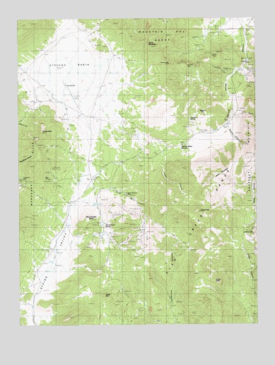
Spring Valley Summit, NV USGS Topographic Map
Click on map above to begin viewing in our Map Viewer.

This topographic map contains these locations and features:
Feature Name Type Latitude Longitude GNIS ID View Map
Atrypa PeakSummitN39.4208°W116.0317°838528View Map
Brush PeakSummitN39.4847°W116.0212°845384View Map
Castle MountainSummitN39.3869°W116.0826°839336View Map
Cave CanyonValleyN39.4655°W116.0120°839366View Map
Dry LakeFlatN39.4749°W116.1031°846312View Map
Dry Lake WellWellN39.4733°W116.1028°840190View Map
Dugout CanyonValleyN39.4580°W116.0145°847316View Map
Dugout TunnelsMineN39.4488°W116.0087°847048View Map
Grays PeakSummitN39.3952°W116.0334°840795View Map
Jones CanyonValleyN39.4694°W116.0873°841410View Map
Josephine SpringSpringN39.4588°W116.0354°841419View Map
Kentucky MineMineN39.4810°W116.0378°841476View Map
Lookout MountainSummitN39.4119°W116.0017°841820View Map
McCulloughs ButteSummitN39.4180°W116.0895°842006View Map
McCulloughs SpringSpringN39.4165°W116.0807°842007View Map
Mountain Boy MineMineN39.4810°W116.0476°842278View Map
Mountain Boy RangeRangeN39.4894°W116.0409°847421View Map
Prospect (historical)Populated PlaceN39.4549°W116.0170°846994View Map
Prospect Mountain TunnelMineN39.4777°W116.0012°847047View Map
Prospect Post Office (historical)Post OfficeN39.4549°W116.0170°864459View Map
Reese and Berry CanyonValleyN39.4327°W116.0962°843187View Map
Reese and Berry MineMineN39.4291°W116.0698°858152View Map
Robinson CanyonValleyN39.4791°W116.0112°843253View Map
Rose MineMineN39.4347°W116.1123°843358View Map
Silver Conner MineMineN39.4816°W116.0056°855812View Map
Spanish MountainSummitN39.4616°W116.0303°845674View Map
Spring ValleyValleyN39.3774°W116.1206°858198View Map
Spring Valley CanyonValleyN39.4974°W116.0070°843946View Map
Spring Valley SummitGapN39.4485°W116.0409°843948View Map
Stevens BasinBasinN39.4758°W116.1045°855811View Map
Swiss MountainSummitN39.4888°W116.0567°844144View Map
Temple PeakSummitN39.4508°W116.1187°844207View Map
White MountainSummitN39.4363°W116.0203°844780View Map

Note: Coordinates in the location and feature list above are referenced to NAD83 datum.


Copyright (C) 2008-2025 Ryan Niemi / Sunset Dynamics ... All Rights Reserved