TopoQuest Logo
Do you find TopoQuest useful?
Help keep TopoQuest running and adding new maps/features by donating!
Bitcoin:  19c7KJd3qBynnjoSw5npx9KScwjBe4ifkT
Litecoin:  LXs6TkuXGGXo1vDsWCkWVdjQX94eUKd6ui
Home View Maps Find Maps Find Places Resources & Links


Blackwater, Arizona Topographic Map

USGS Map Title: Blackwater, AZ
USGS Map MRC: 33111A5
DRG (GeoTIFF) Download: o33111a5.tif


Neighboring USGS Topographic Map Quads:


  Chandler Heights, AZ  
33111B6
 

  Sacaton NE, AZ  
33111B5
 

  Magma, AZ  
33111B4
 

  Sacaton, AZ  
33111A6
 

  Blackwater, AZ  
33111A5
 

  Florence, AZ  
33111A4
 

  Casa Grande East, AZ  
32111H6
 

  Coolidge, AZ  
32111H5
 

  Valley Farms, AZ  
32111H4


Map MRC Location:

N34°
W112°
N34°
W111°
H8 H7 H6 H5 H4 H3 H2 H1
G8 G7 G6 G5 G4 G3 G2 G1
F8 F7 F6 F5 F4 F3 F2 F1
E8 E7 E6 E5 E4 E3 E2 E1
D8 D7 D6 D5 D4 D3 D2 D1
C8 C7 C6 C5 C4 C3 C2 C1
B8 B7 B6 B5 B4 B3 B2 B1
A8 A7 A6 A5 A4 A3 A2 A1
N33°
W112°
N33°
W111°

Blackwater, AZ USGS 1:24K Topographic Map Preview:
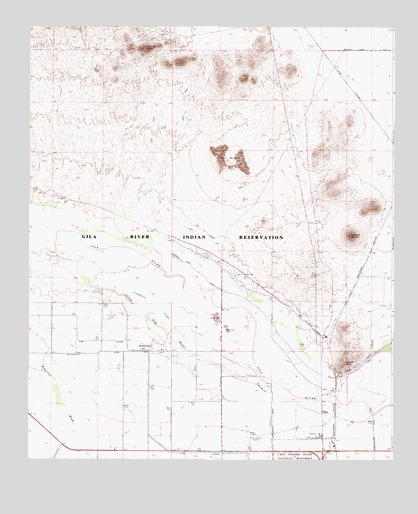
Blackwater, AZ USGS Topographic Map
Click on map above to begin viewing in our Map Viewer.

This topographic map contains these locations and features:
Feature Name Type Latitude Longitude GNIS ID View Map
BlackwaterPopulated PlaceN33.0312°W111.5826°1657View Map
Blackwater Census Designated PlaceCensusN33.0394°W111.5799°2407860View Map
Blackwater Community Center and SchoolSchoolN33.0317°W111.5962°23662View Map
Blackwater LateralCanalN33.0348°W111.5607°1658View Map
Cholla MountainSummitN33.0278°W111.5171°2884View Map
District 1CivilN33.0603°W111.5805°2418907View Map
Gila River Indian Community Fire Department Station 421 BlackwaterBuildingN33.0309°W111.5757°2672642View Map
KCKY-AM (Coolidge)TowerN33.0070°W111.5490°43513View Map
KQEZ-FM (Coolidge)TowerN33.0378°W111.5171°43519View Map
Little Gila RiverStreamN33.0587°W111.6171°7112View Map
Mineral ButteSummitN33.1187°W111.5857°8097View Map
Pinal County Sheriff's Office San Tan Region ABuildingN33.1187°W111.5262°2751641View Map
PostonLocaleN33.0334°W111.5257°23977View Map
Poston Railroad StationBuildingN33.0228°W111.5196°23780View Map
Twin ButtesSummitN33.0887°W111.5615°12930View Map
Walker ButteSummitN33.0648°W111.5146°13283View Map

Note: Coordinates in the location and feature list above are referenced to NAD83 datum.


Copyright (C) 2008-2025 Ryan Niemi / Sunset Dynamics ... All Rights Reserved