TopoQuest Logo
Do you find TopoQuest useful?
Help keep TopoQuest running and adding new maps/features by donating!
Bitcoin:  19c7KJd3qBynnjoSw5npx9KScwjBe4ifkT
Litecoin:  LXs6TkuXGGXo1vDsWCkWVdjQX94eUKd6ui
Home View Maps Find Maps Find Places Resources & Links


Springville, Utah Topographic Map

USGS Map Title: Springville, UT
USGS Map MRC: 40111B5
DRG (GeoTIFF) Download: o40111b5.tif


Neighboring USGS Topographic Map Quads:


  Orem, UT  
40111C6
 

  Bridal Veil Falls, UT  
40111C5
 

  Wallsburg Ridge, UT  
40111C4
 

  Provo, UT  
40111B6
 

  Springville, UT  
40111B5
 

  Granger Mountain, UT  
40111B4
 

  Spanish Fork, UT  
40111A6
 

  Spanish Fork Peak, UT  
40111A5
 

  Billies Mountain, UT  
40111A4


Map MRC Location:

N41°
W112°
N41°
W111°
H8 H7 H6 H5 H4 H3 H2 H1
G8 G7 G6 G5 G4 G3 G2 G1
F8 F7 F6 F5 F4 F3 F2 F1
E8 E7 E6 E5 E4 E3 E2 E1
D8 D7 D6 D5 D4 D3 D2 D1
C8 C7 C6 C5 C4 C3 C2 C1
B8 B7 B6 B5 B4 B3 B2 B1
A8 A7 A6 A5 A4 A3 A2 A1
N40°
W112°
N40°
W111°

Springville, UT USGS 1:24K Topographic Map Preview:
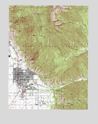
Springville, UT USGS Topographic Map
Click on map above to begin viewing in our Map Viewer.

This topographic map contains these locations and features:
Feature Name Type Latitude Longitude GNIS ID View Map
Art City Elementary SchoolSchoolN40.1678°W111.5947°1448086View Map
Boardman SpringSpringN40.2300°W111.5823°1438977View Map
Brookside Elementary SchoolSchoolN40.1603°W111.5978°1448194View Map
Buckley DrawValleyN40.2069°W111.6216°1439247View Map
Buckley MountainSummitN40.2138°W111.5883°1439249View Map
Burt Spring PondLakeN40.1509°W111.5580°1439382View Map
Camel PassGapN40.1852°W111.5669°1439438View Map
City of SpringvilleCivilN40.1638°W111.6206°2411963View Map
Clyde SpringSpringN40.1507°W111.5869°1439825View Map
Cold SpringSpringN40.2480°W111.5776°1439869View Map
Corral MountainSummitN40.2288°W111.5541°1439979View Map
Deadmans HollowValleyN40.1536°W111.5616°1440319View Map
Dibbles CanyonValleyN40.1308°W111.5013°1440454View Map
Ether HollowValleyN40.1444°W111.5535°1440965View Map
Ether PeakSummitN40.1436°W111.5280°1440966View Map
Evergreen CemeteryCemeteryN40.1406°W111.6032°1440971View Map
Faith Baptist ChurchChurchN40.1686°W111.6110°1450587View Map
Fullmer SpringSpringN40.1492°W111.5910°1441255View Map
Grindstone CanyonValleyN40.1597°W111.5088°1441501View Map
Grindstone RidgeRidgeN40.1411°W111.5096°1441503View Map
Hathenbrook SpringSpringN40.2251°W111.6184°1441630View Map
Historic Springville City CemeteryCemeteryN40.1604°W111.6148°1449050View Map
Horse MountainSummitN40.2136°W111.5757°1441890View Map
IrontonPopulated PlaceN40.1986°W111.6183°1442060View Map
Jefferson SchoolSchoolN40.1561°W111.6099°1442120View Map
Jennings HollowValleyN40.1908°W111.5180°1442121View Map
Kellys Grove Picnic AreaLocaleN40.1630°W111.5002°1437888View Map
Knight SpringSpringN40.2249°W111.5714°1442344View Map
Kolob BasinBasinN40.2025°W111.5755°1442354View Map
Kolob Basin OverlookLocaleN40.2119°W111.5716°1454787View Map
Konold SpringSpringN40.1562°W111.5685°1442356View Map
Left Fork Hobble CreekStreamN40.1625°W111.5007°1442502View Map
Legacy SchoolSchoolN40.1646°W111.6029°1441415View Map
Lincoln SchoolSchoolN40.1672°W111.6091°1442624View Map
Lions CanyonValleyN40.1647°W111.5013°1442649View Map
Little Rock CanyonValleyN40.1875°W111.6127°1442774View Map
Magpie HollowValleyN40.1311°W111.5388°1443078View Map
Maple CanyonValleyN40.1341°W111.5521°1443152View Map
Maple FlatFlatN40.2397°W111.6088°1443163View Map
Maple Slide CanyonValleyN40.1316°W111.5332°1443154View Map
MapletonPopulated PlaceN40.1302°W111.5785°1443189View Map
Mapleton City Police DepartmentBuildingN40.1331°W111.5795°2730423View Map
Mapleton Elementary SchoolSchoolN40.1309°W111.5806°1448646View Map
Mapleton Fire DepartmentBuildingN40.1329°W111.5792°2627185View Map
Osler SpringSpringN40.1551°W111.5677°1444116View Map
Powerhouse MountainSummitN40.1769°W111.5249°1444624View Map
Provo PeakSummitN40.2444°W111.5566°1444666View Map
Rattlesnake PointSummitN40.1472°W111.5488°1444745View Map
Right Fork Hobble CreekStreamN40.1625°W111.5007°1444924View Map
Right Fork Maple CanyonValleyN40.1361°W111.5196°1444939View Map
Round PeakSummitN40.1747°W111.5849°1445175View Map
Sage Creek Elementary SchoolSchoolN40.1509°W111.5989°1448950View Map
Serviceberry HollowValleyN40.1305°W111.5396°1455862View Map
Snowslide CanyonValleyN40.1938°W111.5096°1445753View Map
Spillway HollowValleyN40.1616°W111.5082°1445961View Map
Spring CreekStreamN40.1586°W111.5724°1446000View Map
SpringvillePopulated PlaceN40.1652°W111.6108°1446057View Map
Springville City Police DepartmentBuildingN40.1654°W111.6114°2730380View Map
Springville Community Presbyterian ChurchChurchN40.1630°W111.6066°1450655View Map
Springville Fire and Rescue Station 41BuildingN40.1663°W111.6120°2627196View Map
Springville High SchoolSchoolN40.1552°W111.5881°1449052View Map
Springville Junior High SchoolSchoolN40.1636°W111.5828°1449053View Map
Springville Middle SchoolSchoolN40.1600°W111.6080°1449054View Map
Springville Post OfficePost OfficeN40.1673°W111.6093°1455530View Map
The Church of Jesus Christ of Latter Day SaintsChurchN40.1544°W111.6035°1450978View Map
The Church of Jesus Christ of Latter Day SaintsChurchN40.1619°W111.6105°1450979View Map
The Church of Jesus Christ of Latter Day SaintsChurchN40.1677°W111.6110°1450980View Map
The Church of Jesus Christ of Latter Day SaintsChurchN40.1713°W111.6027°1450981View Map
The Church of Jesus Christ of Latter Day SaintsChurchN40.1625°W111.5999°1450982View Map
The Church of Jesus Christ of Latter Day SaintsChurchN40.1547°W111.5769°1450983View Map
The Church of Jesus Christ of Latter Day SaintsChurchN40.1672°W111.6046°1450984View Map
The Church of Jesus Christ of Latter Day SaintsChurchN40.1591°W111.5985°1450985View Map
The Church of Jesus Christ of Latter Day SaintsChurchN40.1691°W111.5949°1450986View Map
The Church of Jesus Christ of Latter Day SaintsChurchN40.1738°W111.6060°1450987View Map
The Church of Jesus Christ of Latter Day SaintsChurchN40.1300°W111.5791°1449536View Map
The Church of Jesus Christ of Latter Day SaintsChurchN40.1338°W111.5908°1449537View Map
The Church of Jesus Christ of Latter Day SaintsChurchN40.1388°W111.5735°1449538View Map
Three SistersSummitN40.1847°W111.5858°1446572View Map
Toad HeadSummitN40.2191°W111.6074°1446623View Map
Twin RidgesRidgeN40.1772°W111.5749°1446805View Map
Wagon Wheel Trailer ParkPopulated PlaceN40.1597°W111.6105°1449152View Map
Water HollowValleyN40.1977°W111.5013°1447054View Map
Westside Elementary SchoolSchoolN40.1675°W111.6238°1449180View Map
Wheeler SpringsSpringN40.1552°W111.5845°1447217View Map
Whiting CampLocaleN40.1313°W111.5277°1447296View Map

Note: Coordinates in the location and feature list above are referenced to NAD83 datum.


Copyright (C) 2008-2024 Ryan Niemi / Sunset Dynamics ... All Rights Reserved