TopoQuest Logo
Do you find TopoQuest useful?
Help keep TopoQuest running and adding new maps/features by donating!
Bitcoin:  19c7KJd3qBynnjoSw5npx9KScwjBe4ifkT
Litecoin:  LXs6TkuXGGXo1vDsWCkWVdjQX94eUKd6ui
Home View Maps Find Maps Find Places Resources & Links


Bridal Veil Falls, Utah Topographic Map

USGS Map Title: Bridal Veil Falls, UT
USGS Map MRC: 40111C5
DRG (GeoTIFF) Download: o40111c5.tif


Neighboring USGS Topographic Map Quads:


  Timpanogos Cave, UT  
40111D6
 

  Aspen Grove, UT  
40111D5
 

  Charleston, UT  
40111D4
 

  Orem, UT  
40111C6
 

  Bridal Veil Falls, UT  
40111C5
 

  Wallsburg Ridge, UT  
40111C4
 

  Provo, UT  
40111B6
 

  Springville, UT  
40111B5
 

  Granger Mountain, UT  
40111B4


Map MRC Location:

N41°
W112°
N41°
W111°
H8 H7 H6 H5 H4 H3 H2 H1
G8 G7 G6 G5 G4 G3 G2 G1
F8 F7 F6 F5 F4 F3 F2 F1
E8 E7 E6 E5 E4 E3 E2 E1
D8 D7 D6 D5 D4 D3 D2 D1
C8 C7 C6 C5 C4 C3 C2 C1
B8 B7 B6 B5 B4 B3 B2 B1
A8 A7 A6 A5 A4 A3 A2 A1
N40°
W112°
N40°
W111°

Bridal Veil Falls, UT USGS 1:24K Topographic Map Preview:
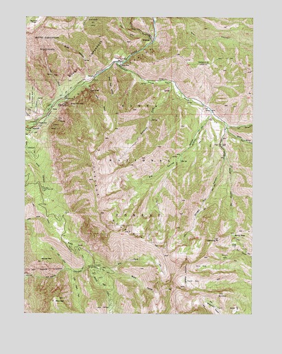
Bridal Veil Falls, UT USGS Topographic Map
Click on map above to begin viewing in our Map Viewer.

This topographic map contains these locations and features:
Feature Name Type Latitude Longitude GNIS ID View Map
Bald KnollSummitN40.2583°W111.5185°1438348View Map
Big Provo CirqueBasinN40.3747°W111.6230°1438723View Map
Big SpringSpringN40.3142°W111.5405°1438734View Map
Big Spring HollowValleyN40.3350°W111.5241°1438743View Map
Bridal Veil FallsFallsN40.3378°W111.6007°1439092View Map
Bridal Veil Falls Sky RideLocaleN40.3388°W111.6024°1454682View Map
Bunnells ForkStreamN40.3477°W111.5446°1439328View Map
Burnt HollowValleyN40.2680°W111.5805°1439356View Map
Canyon GlenPopulated PlaceN40.3302°W111.6188°1439466View Map
Canyon Glen Picnic AreaLocaleN40.3294°W111.6202°1451204View Map
Cascade MountainSummitN40.3072°W111.5888°1439506View Map
Davis CanyonValleyN40.3458°W111.5930°1440282View Map
Dry ForkStreamN40.2680°W111.5802°1440620View Map
First HoleBasinN40.2794°W111.5124°1441052View Map
First Left Fork Rock CanyonValleyN40.2697°W111.6027°1441054View Map
First Right Fork Rock CanyonValleyN40.2686°W111.6024°1441059View Map
Fourth HoleBasinN40.2636°W111.5338°1441198View Map
Frazier Trailer ParkParkN40.3333°W111.5841°1448421View Map
Freedom PeakSummitN40.2609°W111.5446°2071367View Map
Hope Picnic AreaLocaleN40.3019°W111.6152°1441848View Map
Left Fork South Fork Provo RiverStreamN40.3297°W111.5149°1442532View Map
Lightning PeakSummitN40.2822°W111.5219°1442587View Map
Lost CreekStreamN40.3400°W111.6055°1442962View Map
Middle Fork South Fork Provo RiverStreamN40.3291°W111.5146°1443355View Map
Mountain Range CampgroundLocaleN40.3538°W111.5796°1450039View Map
North Fork Provo RiverStreamN40.3647°W111.5566°1443928View Map
NunnsPopulated PlaceN40.3361°W111.6113°1444003View Map
Rock Canyon Picnic AreaLocaleN40.2691°W111.5860°1445054View Map
Rotary ParkParkN40.3363°W111.6171°1454883View Map
Rotary Park Picnic AreaParkN40.3305°W111.6191°1454885View Map
Scott HollowValleyN40.3683°W111.5627°1445384View Map
Second HoleBasinN40.2741°W111.5163°1445403View Map
Second Left Fork Rock CanyonValleyN40.2694°W111.6010°1445405View Map
Second Right Fork Rock CanyonValleyN40.2666°W111.5894°1445408View Map
Shingle Mill CanyonValleyN40.3166°W111.5160°1445535View Map
Shingle Mill PeakSummitN40.2692°W111.5403°2129616View Map
Slide CanyonValleyN40.3494°W111.5905°1445679View Map
Snow Slide CanyonValleyN40.3527°W111.5813°1445748View Map
South Fork Provo RiverStreamN40.3561°W111.5760°1445869View Map
SpringdellPopulated PlaceN40.3280°W111.6244°1446055View Map
Squaw MountainSummitN40.2719°W111.6163°1446080View Map
Third HoleBasinN40.2694°W111.5277°1446524View Map
Timpanogos Glacier (historical)GlacierN40.3663°W111.6202°1449105View Map
Trefoil RanchLocaleN40.3208°W111.5174°1454927View Map
Upper FallsFallsN40.3440°W111.5906°1446860View Map
Vivian ParkPopulated PlaceN40.3550°W111.5741°1446943View Map
Vivian Park Post Office (historical)Post OfficeN40.3550°W111.5741°2027180View Map
Water HollowValleyN40.3277°W111.5160°1447055View Map
WildwoodPopulated PlaceN40.3652°W111.5574°1447368View Map
Windy PassGapN40.2836°W111.5107°1447469View Map
Y MountainSummitN40.2566°W111.6069°1447543View Map

Note: Coordinates in the location and feature list above are referenced to NAD83 datum.


Copyright (C) 2008-2024 Ryan Niemi / Sunset Dynamics ... All Rights Reserved