TopoQuest Logo
Do you find TopoQuest useful?
Help keep TopoQuest running and adding new maps/features by donating!
Bitcoin:  19c7KJd3qBynnjoSw5npx9KScwjBe4ifkT
Litecoin:  LXs6TkuXGGXo1vDsWCkWVdjQX94eUKd6ui
Home View Maps Find Maps Find Places Resources & Links


Albion, Oklahoma Topographic Map

USGS Map Title: Albion, OK
USGS Map MRC: 34095F1
DRG (GeoTIFF) Download: o34095f1.tif


Neighboring USGS Topographic Map Quads:


  Baker Mountain, OK  
34095G2
 

  Talihina, OK  
34095G1
 

  Blackjack Ridge, OK  
34094G8
 

  Kiamichi, OK  
34095F2
 

  Albion, OK  
34095F1
 

  Whitesboro, OK  
34094F8
 

  Albion SW, OK  
34095E2
 

  Albion SE, OK  
34095E1
 

  Honobia, OK  
34094E8


Map MRC Location:

N35°
W96°
N35°
W95°
H8 H7 H6 H5 H4 H3 H2 H1
G8 G7 G6 G5 G4 G3 G2 G1
F8 F7 F6 F5 F4 F3 F2 F1
E8 E7 E6 E5 E4 E3 E2 E1
D8 D7 D6 D5 D4 D3 D2 D1
C8 C7 C6 C5 C4 C3 C2 C1
B8 B7 B6 B5 B4 B3 B2 B1
A8 A7 A6 A5 A4 A3 A2 A1
N34°
W96°
N34°
W95°

Albion, OK USGS 1:24K Topographic Map Preview:
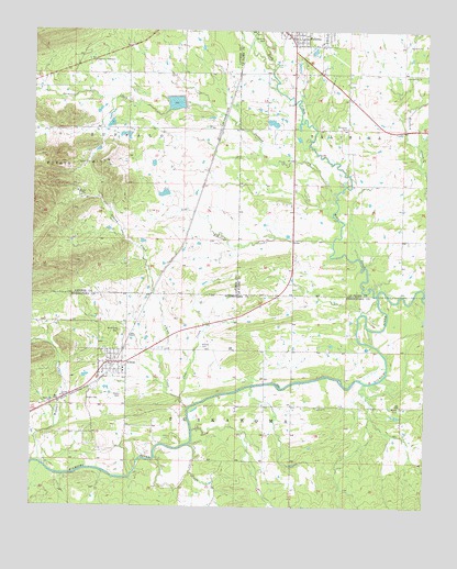
Albion, OK USGS Topographic Map
Click on map above to begin viewing in our Map Viewer.

This topographic map contains these locations and features:
Feature Name Type Latitude Longitude GNIS ID View Map
AlbionPopulated PlaceN34.6629°W95.1000°1089573View Map
Albion CemeteryCemeteryN34.6669°W95.0713°1089574View Map
Albion CreekStreamN34.6532°W95.0775°1089575View Map
Albion Elementary SchoolSchoolN34.6612°W95.0960°1790536View Map
Albion Fire DepartmentBuildingN34.6651°W95.1003°2657435View Map
Armstrong CemeteryCemeteryN34.6711°W95.0973°1089700View Map
Clear CreekStreamN34.6532°W95.0777°1091411View Map
Evangelistic TabernacleLocaleN34.7423°W95.1069°1092661View Map
Green Hill ChurchChurchN34.7384°W95.0030°1093375View Map
Head ChurchChurchN34.6512°W95.0338°1093630View Map
Heath CemeteryCemeteryN34.6543°W95.0967°1093639View Map
Homer Ranch Airport (historical)AirportN34.6584°W95.0711°1102349View Map
Jackson CreekStreamN34.7054°W95.0291°1094154View Map
Little Buzzard CreekStreamN34.7243°W95.0075°1101508View Map
Martha Lingenfelter LakeReservoirN34.7468°W95.0369°1750973View Map
Martha Lingenfelter Lake DamDamN34.7468°W95.0369°1750972View Map
McIntosh CemeteryCemeteryN34.7251°W95.0257°1095242View Map
Myers CemeteryCemeteryN34.6509°W95.0080°1095730View Map
Noah CemeteryCemeteryN34.6533°W95.1073°1095891View Map
Oknoname 077002 DamDamN34.7068°W95.0819°1755573View Map
Oknoname 077002 ReservoirReservoirN34.7065°W95.0819°1755574View Map
Oknoname 077006 DamDamN34.7151°W95.0869°1755581View Map
Oknoname 077006 ReservoirReservoirN34.7152°W95.0870°1755582View Map
Old Talihina CemeteryCemeteryN34.7482°W95.0522°1098732View Map
Prairie CreekStreamN34.6934°W95.0300°1096894View Map
Rock CreekStreamN34.6807°W95.0155°1101634View Map
Rock Creek Site 1 DamDamN34.7301°W95.0769°1750815View Map
Rock Creek Site 1 ReservoirReservoirN34.7311°W95.0801°1750816View Map
Talihina Municipal AirportAirportN34.7100°W95.0733°1102687View Map
Town of AlbionCivilN34.6623°W95.0992°2412344View Map
Walnut CreekStreamN34.6357°W95.1205°1099320View Map

Note: Coordinates in the location and feature list above are referenced to NAD83 datum.


Copyright (C) 2008-2025 Ryan Niemi / Sunset Dynamics ... All Rights Reserved