TopoQuest Logo
Do you find TopoQuest useful?
Help keep TopoQuest running and adding new maps/features by donating!
Bitcoin:  19c7KJd3qBynnjoSw5npx9KScwjBe4ifkT
Litecoin:  LXs6TkuXGGXo1vDsWCkWVdjQX94eUKd6ui
Home View Maps Find Maps Find Places Resources & Links


Stedman, North Carolina Topographic Map

USGS Map Title: Stedman, NC
USGS Map MRC: 35078A6
DRG (GeoTIFF) Download: o35078a6.tif


Neighboring USGS Topographic Map Quads:


  Slocomb, NC  
35078B7
 

  Wade, NC  
35078B6
 

  Mingo, NC  
35078B5
 

  Vander, NC  
35078A7
 

  Stedman, NC  
35078A6
 

  Salemburg, NC  
35078A5
 

  Cedar Creek, NC  
34078H7
 

  Autryville, NC  
34078H6
 

  Roseboro, NC  
34078H5


Map MRC Location:

N36°
W79°
N36°
W78°
H8 H7 H6 H5 H4 H3 H2 H1
G8 G7 G6 G5 G4 G3 G2 G1
F8 F7 F6 F5 F4 F3 F2 F1
E8 E7 E6 E5 E4 E3 E2 E1
D8 D7 D6 D5 D4 D3 D2 D1
C8 C7 C6 C5 C4 C3 C2 C1
B8 B7 B6 B5 B4 B3 B2 B1
A8 A7 A6 A5 A4 A3 A2 A1
N35°
W79°
N35°
W78°

Stedman, NC USGS 1:24K Topographic Map Preview:
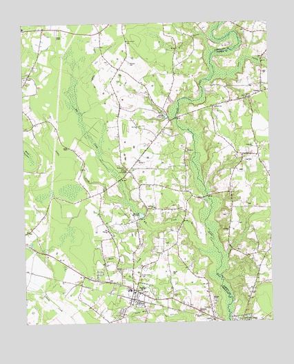
Stedman, NC USGS Topographic Map
Click on map above to begin viewing in our Map Viewer.

This topographic map contains these locations and features:
Feature Name Type Latitude Longitude GNIS ID View Map
Autry CemeteryCemeteryN35.1040°W78.6275°980377View Map
Bethany ChurchChurchN35.0649°W78.6989°981068View Map
Bethany ChurchChurchN35.0679°W78.6914°981069View Map
Bethany CrossroadsPopulated PlaceN35.0635°W78.6967°1019106View Map
Bethany Fire DepartmentBuildingN35.0629°W78.6953°2639062View Map
Big CreekStreamN35.0291°W78.6520°981378View Map
Brotherhood Holiness ChurchChurchN35.0043°W78.6622°981992View Map
Browns SwampStreamN35.1121°W78.6536°982043View Map
Buck CreekStreamN35.0388°W78.6839°982102View Map
Chapel Hill ChurchChurchN35.0732°W78.6333°983013View Map
China Grove ChurchChurchN35.0202°W78.6909°983143View Map
ClementPopulated PlaceN35.0957°W78.6286°983265View Map
Clement ChurchChurchN35.0938°W78.6364°983266View Map
Coates Airport (historical)AirportN35.1196°W78.7317°1001095View Map
Cokesbury ChurchChurchN35.0121°W78.6922°983347View Map
Faircloths BridgeBridgeN35.0524°W78.6567°1960060View Map
Fisher CemeteryCemeteryN35.0218°W78.7008°985099View Map
Gainey MillpondReservoirN35.0863°W78.6773°985517View Map
Galilee ChurchChurchN35.0116°W78.6750°985525View Map
Hall CemeteryCemeteryN35.0674°W78.6372°986309View Map
Home CemeteryCemeteryN35.0118°W78.6356°987001View Map
Johnson CemeteryCemeteryN35.0004°W78.6325°987660View Map
Jones SwampStreamN35.1027°W78.6528°987763View Map
Little CreekStreamN35.0496°W78.6967°988584View Map
Magnolia ChurchChurchN35.0382°W78.7078°989235View Map
Maxwell BridgeBridgeN35.0852°W78.6722°1960062View Map
Maxwell CemeteryCemeteryN35.0899°W78.6528°989490View Map
Maxwell MillpondReservoirN35.0448°W78.6905°989493View Map
McCall CemeteryCemeteryN35.0207°W78.6753°989530View Map
Moores Chapel United Methodist ChurchChurchN35.0732°W78.7272°990190View Map
New Hope ChurchChurchN35.0818°W78.6911°990996View Map
Oak Grove ChurchChurchN35.0482°W78.6839°991365View Map
Riverside ChurchChurchN35.0382°W78.6464°993389View Map
Sandy Grove ChurchChurchN35.1177°W78.6970°994279View Map
StedmanPopulated PlaceN35.0135°W78.6939°995445View Map
Stedman Elementary SchoolSchoolN35.0127°W78.6945°1006559View Map
Stedman Fire DepartmentBuildingN35.0122°W78.6896°2638617View Map
Stedman Junior High SchoolSchoolN35.0138°W78.6967°1006560View Map
Stedman Post OfficePost OfficeN35.0131°W78.6919°2773950View Map
Town of StedmanCivilN35.0129°W78.7027°2406663View Map
Williams CemeteryCemeteryN35.1085°W78.6958°997367View Map

Note: Coordinates in the location and feature list above are referenced to NAD83 datum.


Copyright (C) 2008-2024 Ryan Niemi / Sunset Dynamics ... All Rights Reserved