TopoQuest Logo
Do you find TopoQuest useful?
Help keep TopoQuest running and adding new maps/features by donating!
Bitcoin:  19c7KJd3qBynnjoSw5npx9KScwjBe4ifkT
Litecoin:  LXs6TkuXGGXo1vDsWCkWVdjQX94eUKd6ui
Home View Maps Find Maps Find Places Resources & Links


Slocomb, North Carolina Topographic Map

USGS Map Title: Slocomb, NC
USGS Map MRC: 35078B7
DRG (GeoTIFF) Download: o35078b7.tif


Neighboring USGS Topographic Map Quads:


  Anderson Creek, NC  
35078C8
 

  Bunnlevel, NC  
35078C7
 

  Erwin, NC  
35078C6
 

  Manchester, NC  
35078B8
 

  Slocomb, NC  
35078B7
 

  Wade, NC  
35078B6
 

  Fayetteville, NC  
35078A8
 

  Vander, NC  
35078A7
 

  Stedman, NC  
35078A6


Map MRC Location:

N36°
W79°
N36°
W78°
H8 H7 H6 H5 H4 H3 H2 H1
G8 G7 G6 G5 G4 G3 G2 G1
F8 F7 F6 F5 F4 F3 F2 F1
E8 E7 E6 E5 E4 E3 E2 E1
D8 D7 D6 D5 D4 D3 D2 D1
C8 C7 C6 C5 C4 C3 C2 C1
B8 B7 B6 B5 B4 B3 B2 B1
A8 A7 A6 A5 A4 A3 A2 A1
N35°
W79°
N35°
W78°

Slocomb, NC USGS 1:24K Topographic Map Preview:
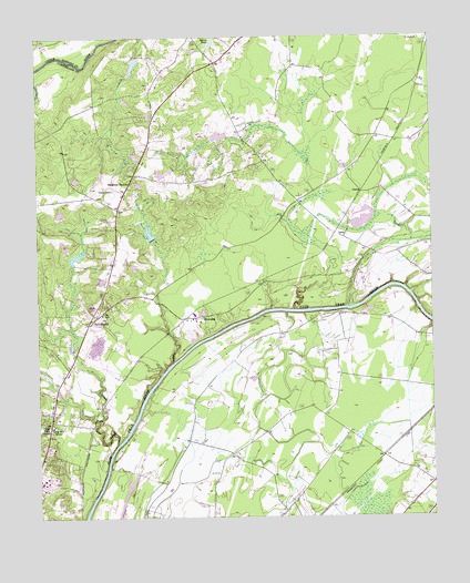
Slocomb, NC USGS Topographic Map
Click on map above to begin viewing in our Map Viewer.

This topographic map contains these locations and features:
Feature Name Type Latitude Longitude GNIS ID View Map
Barnes LakeReservoirN35.2190°W78.8430°998599View Map
Barnes Lake DamDamN35.2185°W78.8414°998598View Map
CarlosPopulated PlaceN35.2096°W78.7717°1019530View Map
Carvers CreekStreamN35.1446°W78.8495°982713View Map
Carvers Creek Fire DepartmentBuildingN35.1822°W78.8548°2639056View Map
Cedar Falls ChurchChurchN35.1491°W78.8711°982825View Map
Clarks LakeReservoirN35.2429°W78.8437°998655View Map
Clarks Lake DamDamN35.2452°W78.8414°998654View Map
Currin LakeReservoirN35.1931°W78.8624°998518View Map
Currin Lake DamDamN35.1918°W78.8631°998517View Map
Ennis PondReservoirN35.2478°W78.8194°984802View Map
Flyers AirparkAirportN35.2177°W78.7968°2679213View Map
LanePopulated PlaceN35.1977°W78.7775°1021096View Map
Long Hill SchoolSchoolN35.1485°W78.8703°988971View Map
Methodist CollegeSchoolN35.1343°W78.8742°1007363View Map
Palestine ChurchChurchN35.2124°W78.8459°991794View Map
Raleigh Road KindergartenSchoolN35.2171°W78.8409°1006527View Map
SlocombPopulated PlaceN35.1774°W78.8236°1022667View Map
Smith Lake DamDamN35.2235°W78.8147°998616View Map
Smiths LakeReservoirN35.2240°W78.8168°998617View Map
Township of Carvers CreekCivilN35.1980°W78.8302°1026596View Map
Windemere AirportAirportN35.1379°W78.8237°2679174View Map
Windsor Farms AirportAirportN35.2258°W78.8210°2717301View Map
Zion ChurchChurchN35.1760°W78.8581°997763View Map

Note: Coordinates in the location and feature list above are referenced to NAD83 datum.


Copyright (C) 2008-2025 Ryan Niemi / Sunset Dynamics ... All Rights Reserved