TopoQuest Logo
Do you find TopoQuest useful?
Help keep TopoQuest running and adding new maps/features by donating!
Bitcoin:  19c7KJd3qBynnjoSw5npx9KScwjBe4ifkT
Litecoin:  LXs6TkuXGGXo1vDsWCkWVdjQX94eUKd6ui
Home View Maps Find Maps Find Places Resources & Links


Steele Peak, California Topographic Map

USGS Map Title: Steele Peak, CA
USGS Map MRC: 33117G3
DRG (GeoTIFF) Download: o33117g3.tif


Neighboring USGS Topographic Map Quads:


  Riverside West, CA  
33117H4
 

  Riverside East, CA  
33117H3
 

  Sunnymead, CA  
33117H2
 

  Lake Mathews, CA  
33117G4
 

  Steele Peak, CA  
33117G3
 

  Perris, CA  
33117G2
 

  Alberhill, CA  
33117F4
 

  Lake Elsinore, CA  
33117F3
 

  Romoland, CA  
33117F2


Map MRC Location:

N34°
W118°
N34°
W117°
H8 H7 H6 H5 H4 H3 H2 H1
G8 G7 G6 G5 G4 G3 G2 G1
F8 F7 F6 F5 F4 F3 F2 F1
E8 E7 E6 E5 E4 E3 E2 E1
D8 D7 D6 D5 D4 D3 D2 D1
C8 C7 C6 C5 C4 C3 C2 C1
B8 B7 B6 B5 B4 B3 B2 B1
A8 A7 A6 A5 A4 A3 A2 A1
N33°
W118°
N33°
W117°

Steele Peak, CA USGS 1:24K Topographic Map Preview:
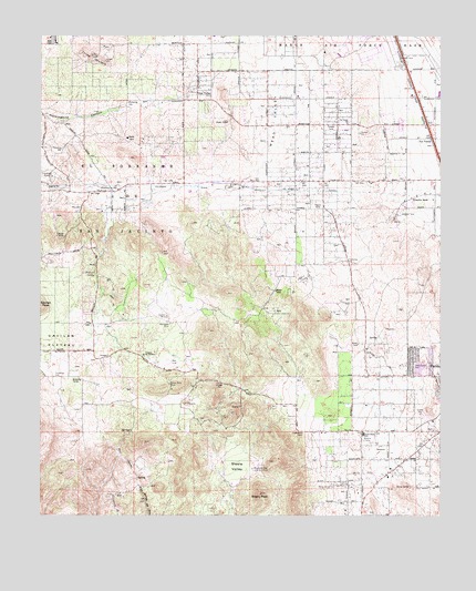
Steele Peak, CA USGS Topographic Map
Click on map above to begin viewing in our Map Viewer.

This topographic map contains these locations and features:
Feature Name Type Latitude Longitude GNIS ID View Map
Bethel ChurchChurchN33.7653°W117.2578°239261View Map
Bible Way Missionary ChurchChurchN33.8339°W117.2939°1848992View Map
Cajalco Fire StationLocaleN33.8359°W117.3520°1654575View Map
California Department of Forestry and Fire Protection Cajalco Fire Station 4BuildingN33.8349°W117.3517°2664974View Map
Camelot HillsPopulated PlaceN33.7684°W117.3362°1848952View Map
Camp Haan (historical)LocaleN33.8714°W117.2662°1701103View Map
County Rescue Ambulance ServiceBuildingN33.8549°W117.2557°2665478View Map
Evangelist Centre ChurchChurchN33.8517°W117.2712°1848998View Map
First Baptist ChurchChurchN33.8603°W117.3289°1848964View Map
Gavilan HillsPopulated PlaceN33.7845°W117.3692°1848970View Map
Gavilan MineMineN33.8020°W117.3359°242656View Map
Glen ValleyPopulated PlaceN33.8620°W117.3262°1660678View Map
Glen View Elementary SchoolSchoolN33.8589°W117.2956°1849000View Map
Good HopePopulated PlaceN33.7647°W117.2670°1848971View Map
Good Hope Census Designated PlaceCensusN33.7706°W117.2772°2583026View Map
Good Hope Elementary SchoolSchoolN33.7712°W117.2750°242843View Map
Good Hope Missionary Baptist ChurchChurchN33.7645°W117.2598°1848972View Map
Good MeadowPopulated PlaceN33.7661°W117.2842°1848973View Map
Harford SpringSpringN33.8129°W117.3588°243261View Map
Hartford Spring County ParkParkN33.8117°W117.3511°1848974View Map
Higher Ground Baptist ChurchChurchN33.7664°W117.2798°1848975View Map
Ida-Leona MineMineN33.8000°W117.3348°243767View Map
Interchange 22CrossingN33.8437°W117.2508°2455426View Map
Interchange 23CrossingN33.8625°W117.2597°2455427View Map
Lake Mathews Census Designated PlaceCensusN33.8250°W117.3683°2583051View Map
Lighthouse Christian AcademySchoolN33.7615°W117.2567°2455708View Map
Lighthouse Community ChurchChurchN33.7609°W117.2567°1848979View Map
Maywood Rod and Gun ClubLocaleN33.7622°W117.3092°1654724View Map
Mead ValleyPopulated PlaceN33.8334°W117.2962°1849005View Map
Mead ValleyValleyN33.8370°W117.3153°245727View Map
Mead Valley Census Designated PlaceCensusN33.8333°W117.2852°2583077View Map
Mead Valley Community CenterBuildingN33.8297°W117.2934°1849006View Map
Mead Valley Elementary SchoolSchoolN33.8595°W117.2947°1849007View Map
Mead Valley Post OfficePost OfficeN33.8370°W117.2881°1849016View Map
Morris Washington RanchLocaleN33.8031°W117.2803°1701115View Map
Motte Rimrock ReserveParkN33.8006°W117.2553°1848980View Map
Mount Moriah Baptist ChurchChurchN33.8725°W117.3317°1848981View Map
New Hope Missionary Baptist ChurchChurchN33.8634°W117.3253°2455312View Map
New Visions Christian ChurchChurchN33.8725°W117.3409°1848982View Map
Rancho de las PiedrasLocaleN33.7925°W117.3398°247954View Map
Rancho Loma De OroLocaleN33.7736°W117.2975°1701117View Map
Riverside County Fire Department Station 59 - Mead ValleyBuildingN33.8321°W117.2871°2664976View Map
Riverside County Fire Department Station 9 GoodmeadowBuildingN33.7623°W117.2830°2665026View Map
Santa Rosa MineMineN33.7842°W117.3350°249113View Map
Santa Rosa Ranch EstatesPopulated PlaceN33.7792°W117.3537°1848984View Map
Steele PeakSummitN33.7556°W117.3070°249898View Map
Steele ValleyBasinN33.7653°W117.3148°249900View Map
The Church of Jesus Christ of Latter Day SaintsChurchN33.8749°W117.3672°2455370View Map
Three SistersRangeN33.8697°W117.3595°250475View Map
Tomas Rivera Middle SchoolSchoolN33.8441°W117.2848°1849031View Map
University of California Ecological Study AreaParkN33.8200°W117.2764°1849032View Map
Val VerdePopulated PlaceN33.8484°W117.2539°252999View Map
Val Verde TunnelTunnelN33.8347°W117.2914°250886View Map
Wagonwheel RanchLocaleN33.7781°W117.2653°1701120View Map

Note: Coordinates in the location and feature list above are referenced to NAD83 datum.


Copyright (C) 2008-2024 Ryan Niemi / Sunset Dynamics ... All Rights Reserved