TopoQuest Logo
Do you find TopoQuest useful?
Help keep TopoQuest running and adding new maps/features by donating!
Bitcoin:  19c7KJd3qBynnjoSw5npx9KScwjBe4ifkT
Litecoin:  LXs6TkuXGGXo1vDsWCkWVdjQX94eUKd6ui
Home View Maps Find Maps Find Places Resources & Links


Stephenson, Virginia Topographic Map

USGS Map Title: Stephenson, VA
USGS Map MRC: 39078B1
DRG (GeoTIFF) Download: o39078b1.tif


Neighboring USGS Topographic Map Quads:


  White Hall, VA  
39078C2
 

  Inwood, WV  
39078C1
 

  Middleway, WV  
39077C8
 

  Winchester, VA  
39078B2
 

  Stephenson, VA  
39078B1
 

  Berryville, VA  
39077B8
 

  Stephens City, VA  
39078A2
 

  Boyce, VA  
39078A1
 

  Ashby Gap, VA  
39077A8


Map MRC Location:

N40°
W79°
N40°
W78°
H8 H7 H6 H5 H4 H3 H2 H1
G8 G7 G6 G5 G4 G3 G2 G1
F8 F7 F6 F5 F4 F3 F2 F1
E8 E7 E6 E5 E4 E3 E2 E1
D8 D7 D6 D5 D4 D3 D2 D1
C8 C7 C6 C5 C4 C3 C2 C1
B8 B7 B6 B5 B4 B3 B2 B1
A8 A7 A6 A5 A4 A3 A2 A1
N39°
W79°
N39°
W78°

Stephenson, VA USGS 1:24K Topographic Map Preview:
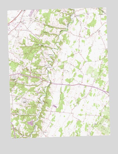
Stephenson, VA USGS Topographic Map
Click on map above to begin viewing in our Map Viewer.

This topographic map contains these locations and features:
Feature Name Type Latitude Longitude GNIS ID View Map
Abrams CreekStreamN39.1809°W78.0747°1478091View Map
Abrams Creek School (historical)SchoolN39.1770°W78.0994°2025385View Map
Annefield EstateLocaleN39.1262°W78.0281°1690522View Map
Ash Hollow RunStreamN39.1815°W78.0844°1462585View Map
Berryville CrossingCrossingN39.1782°W78.0733°2025370View Map
Blue Ridge Mobile Home ParkPopulated PlaceN39.1834°W78.1003°2025379View Map
Brentwood TerracePopulated PlaceN39.1798°W78.1219°2025380View Map
Buffalo Lick RunStreamN39.1251°W78.1022°1478289View Map
Burning KnollsPopulated PlaceN39.1609°W78.1039°1499192View Map
Burnt FactoryPopulated PlaceN39.1945°W78.0761°1499194View Map
Carpers ValleyValleyN39.1271°W78.1105°1464455View Map
Carpers Valley ChurchChurchN39.1273°W78.1056°1464456View Map
Cather EstatesPopulated PlaceN39.1995°W78.0061°1690557View Map
Clarke County Recreation AreaParkN39.1618°W78.0033°1690568View Map
Clearbrook RunStreamN39.2393°W78.0869°1464971View Map
CleridgeBuildingN39.2247°W78.0611°2705685View Map
Clevengers FordCrossingN39.2048°W78.0692°2025371View Map
Country ParkPopulated PlaceN39.1709°W78.1244°2025381View Map
Crums CemeteryCemeteryN39.2093°W78.0017°1690574View Map
Crums ChurchChurchN39.2090°W78.0019°1465498View Map
Devils BackboneRidgeN39.2057°W78.0978°1465741View Map
Dry Marsh RunStreamN39.1934°W78.0708°1466000View Map
Edgewood School (historical)SchoolN39.2023°W78.0797°2025386View Map
Emmanuel ChurchChurchN39.2382°W78.1086°1466296View Map
Frederick County Fire and Rescue Department Station 18 - Greenwood Volunteer Fire and RescueBuildingN39.1694°W78.1220°2075419View Map
FreycoPopulated PlaceN39.2412°W78.0978°1499454View Map
Glendale School (historical)SchoolN39.1982°W78.0625°1690589View Map
Greenwood CemeteryCemeteryN39.1720°W78.1219°2025366View Map
Greenwood ChurchChurchN39.1718°W78.1225°1467524View Map
Greenwood HeightsPopulated PlaceN39.1651°W78.1175°1499504View Map
Greenwood Mills (historical)LocaleN39.1801°W78.1167°2025377View Map
Hawthorne School (historical)SchoolN39.1982°W78.0197°1690601View Map
Helmsley EstateLocaleN39.1534°W78.0772°1690602View Map
Hiatt RunStreamN39.2137°W78.0931°1467966View Map
High View Farm AirportAirportN39.2389°W78.0105°1498592View Map
Holy Trinity Mission SeminaryChurchN39.2154°W78.0858°1468196View Map
Horsepen SpringSpringN39.1365°W78.0194°1468302View Map
Hot RunStreamN39.2307°W78.0500°1468510View Map
House of JacobChurchN39.1951°W78.1039°2025368View Map
Hout School (historical)SchoolN39.2490°W78.0283°1690604View Map
Isaac RunStreamN39.1612°W78.0861°1468525View Map
Jabbers Hill CemeteryCemeteryN39.2473°W78.0503°1468570View Map
Jonesville EstateLocaleN39.1465°W78.0511°1690606View Map
Jordan SpringsPopulated PlaceN39.2154°W78.0839°1499612View Map
KeenelandPopulated PlaceN39.1529°W78.0608°1690607View Map
Keystone Christian AcademySchoolN39.1759°W78.0640°1690608View Map
Keystone EstatesPopulated PlaceN39.1795°W78.0683°1690609View Map
LeetownPopulated PlaceN39.2270°W78.0775°1477483View Map
Leetown School (historical)SchoolN39.2273°W78.0783°2025387View Map
Lick RunStreamN39.2118°W78.0678°1469408View Map
Milburn CemeteryCemeteryN39.2241°W78.1131°1470451View Map
Milburn Chapel (historical)ChurchN39.2243°W78.1131°2025369View Map
Millbrook High SchoolSchoolN39.1912°W78.1151°2499247View Map
Minnie Wood Chapel (historical)ChurchN39.1762°W78.0508°1690627View Map
Mount PleasantPopulated PlaceN39.1732°W78.0206°1690633View Map
Mount Sinai ChurchChurchN39.2270°W78.0778°1471068View Map
North End EstateLocaleN39.1440°W78.0469°1690639View Map
Old Salem CemeteryCemeteryN39.1301°W78.0825°1690646View Map
Old Salem ChurchChurchN39.1301°W78.0828°1471873View Map
Payne Mobile Home ParkPopulated PlaceN39.2370°W78.1181°2025382View Map
Pines Corner School (historical)SchoolN39.1543°W78.0425°1690651View Map
Red Bud DistrictCivilN39.1701°W78.1081°1930433View Map
Red Bud School (historical)SchoolN39.1757°W78.1019°2025388View Map
Redbud CemeteryCemeteryN39.1920°W78.0914°1473066View Map
Redbud CemeteryCemeteryN39.1757°W78.1017°2025367View Map
Redbud ChurchChurchN39.1920°W78.1019°1473067View Map
Redbud RunStreamN39.1876°W78.0761°1473069View Map
Redbud Run Elementary SchoolSchoolN39.1906°W78.1127°2499240View Map
Rock HallPopulated PlaceN39.1684°W78.0603°1690661View Map
Rocky FordCrossingN39.2312°W78.0497°2025372View Map
Russell DistrictCivilN39.1945°W78.0155°1927480View Map
Seivers FordCrossingN39.2243°W78.0603°2025373View Map
Seventh Day Adventist SchoolSchoolN39.1765°W78.0697°1690672View Map
Shenandoah HillsPopulated PlaceN39.1848°W78.1183°1500088View Map
Sheppard DamDamN39.1734°W78.0964°1489828View Map
Sheppard PondReservoirN39.1734°W78.0964°1489829View Map
Slate RunStreamN39.2434°W78.0428°1474678View Map
Spring Meadows Trailer ParkPopulated PlaceN39.2390°W78.1064°2025383View Map
StephensonPopulated PlaceN39.2373°W78.1064°1740338View Map
Stephenson Post OfficePost OfficeN39.2338°W78.1133°2025390View Map
Stones ChapelChurchN39.2265°W78.0106°1475191View Map
Stones Chapel CemeteryCemeteryN39.2262°W78.0103°1690681View Map
Stonewall DistrictCivilN39.2455°W78.1120°1927523View Map
Stonewall Elementary SchoolSchoolN39.2498°W78.1031°1475198View Map
Sulfur Spring School (historical)SchoolN39.1495°W78.1169°2025389View Map
Sulphur Spring FordCrossingN39.1476°W78.0903°2025374View Map
Sulphur Spring RunStreamN39.1470°W78.0908°1475315View Map
SwimleyPopulated PlaceN39.2429°W78.0075°1477798View Map
Tanquarys FordCrossingN39.1934°W78.0742°2025375View Map
The Cottage EstateLocaleN39.1259°W78.0206°1690685View Map
Turkey RunStreamN39.2484°W78.0400°1475961View Map
Valley Mill (historical)LocaleN39.1793°W78.0861°2025378View Map
WadesvillePopulated PlaceN39.2426°W78.0389°1477848View Map
Wamplers Trailer ParkPopulated PlaceN39.2354°W78.1100°2025384View Map

Note: Coordinates in the location and feature list above are referenced to NAD83 datum.


Copyright (C) 2008-2024 Ryan Niemi / Sunset Dynamics ... All Rights Reserved