TopoQuest Logo
Do you find TopoQuest useful?
Help keep TopoQuest running and adding new maps/features by donating!
Bitcoin:  19c7KJd3qBynnjoSw5npx9KScwjBe4ifkT
Litecoin:  LXs6TkuXGGXo1vDsWCkWVdjQX94eUKd6ui
Home View Maps Find Maps Find Places Resources & Links


Stephens City, Virginia Topographic Map

USGS Map Title: Stephens City, VA
USGS Map MRC: 39078A2
DRG (GeoTIFF) Download: o39078a2.tif


Neighboring USGS Topographic Map Quads:


  Hayfield, VA  
39078B3
 

  Winchester, VA  
39078B2
 

  Stephenson, VA  
39078B1
 

  Middletown, VA  
39078A3
 

  Stephens City, VA  
39078A2
 

  Boyce, VA  
39078A1
 

  Strasburg, VA  
38078H3
 

  Front Royal, VA  
38078H2
 

  Linden, VA  
38078H1


Map MRC Location:

N40°
W79°
N40°
W78°
H8 H7 H6 H5 H4 H3 H2 H1
G8 G7 G6 G5 G4 G3 G2 G1
F8 F7 F6 F5 F4 F3 F2 F1
E8 E7 E6 E5 E4 E3 E2 E1
D8 D7 D6 D5 D4 D3 D2 D1
C8 C7 C6 C5 C4 C3 C2 C1
B8 B7 B6 B5 B4 B3 B2 B1
A8 A7 A6 A5 A4 A3 A2 A1
N39°
W79°
N39°
W78°

Stephens City, VA USGS 1:24K Topographic Map Preview:
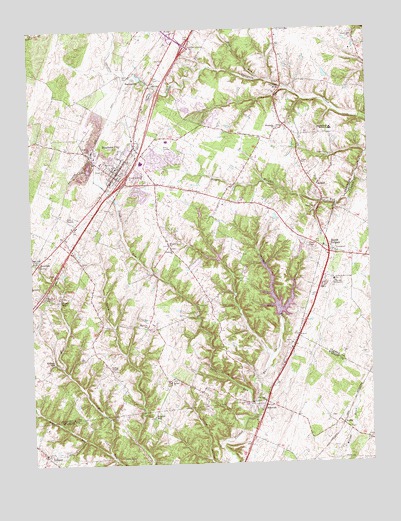
Stephens City, VA USGS Topographic Map
Click on map above to begin viewing in our Map Viewer.

This topographic map contains these locations and features:
Feature Name Type Latitude Longitude GNIS ID View Map
Admiral Richard E Byrd Middle SchoolSchoolN39.1244°W78.1489°2499217View Map
ArmelPopulated PlaceN39.0793°W78.1436°1499061View Map
Armel Elementary SchoolSchoolN39.1025°W78.1561°1462553View Map
AshbyPopulated PlaceN39.0109°W78.1353°1499065View Map
BartonsvillePopulated PlaceN39.1115°W78.2119°1499094View Map
Bass - Hoover Elementary SchoolSchoolN39.0930°W78.1987°1779202View Map
Bunker HillPopulated PlaceN39.0134°W78.2056°1499188View Map
CanterburgPopulated PlaceN39.0468°W78.1842°1779205View Map
Cedar Cliff ChurchChurchN39.0584°W78.2483°1464589View Map
Do-Nothing FarmLocaleN39.0029°W78.1497°1674094View Map
Double TollgateLocaleN39.0612°W78.1383°1465907View Map
Dry RunStreamN39.0026°W78.2214°1466011View Map
ErinBuildingN39.0162°W78.1667°1674098View Map
Fairview CemeteryCemeteryN39.0621°W78.1981°1779217View Map
Fairview ChurchChurchN39.0618°W78.1972°1466417View Map
Frederick County Fire and Rescue Department Station 11 - Stephens City Volunteer Fire and RescueBuildingN39.0838°W78.2159°2075412View Map
Friendship CemeteryCemeteryN39.0632°W78.1989°1779220View Map
Friendship ChurchChurchN39.0629°W78.1983°1466897View Map
Golden AcresLocaleN39.0054°W78.1269°1674111View Map
Green Hill CemeteryCemeteryN39.0848°W78.2203°1467471View Map
Greenway Southern Baptist ChurchChurchN39.0612°W78.1389°1690597View Map
Gun Barrel Lane EstatesPopulated PlaceN39.0593°W78.1261°1690599View Map
Highview SchoolSchoolN39.0393°W78.2069°1468040View Map
Hoge RunStreamN39.1106°W78.1638°1478769View Map
Interchange 307CrossingN39.0815°W78.2156°1779228View Map
Interchange 310CrossingN39.1207°W78.1914°1779229View Map
Klines MillPopulated PlaceN39.0471°W78.2406°1499634View Map
Lake FrederickReservoirN39.0423°W78.1586°1779219View Map
Lake FrederickPopulated PlaceN39.0432°W78.1616°2519270View Map
Lakeside LakeReservoirN39.1020°W78.1914°1489854View Map
Lakeside Lake DamDamN39.1018°W78.1897°1489853View Map
Liberty Baptist ChurchChurchN39.0812°W78.2197°1779237View Map
Macedonia CemeteryCemeteryN39.0965°W78.1581°1779240View Map
Macedonia ChurchChurchN39.0965°W78.1572°1469981View Map
Mountain View Christian AcademySchoolN39.1147°W78.2039°2499255View Map
Ninevah Presbyterian ChurchChurchN39.0123°W78.1678°1674044View Map
NinevehPopulated PlaceN39.0159°W78.1650°1499802View Map
Old Zion ChurchChurchN39.0182°W78.1642°1471889View Map
Opequon DistrictCivilN39.0501°W78.2074°1927434View Map
Parkins MillsPopulated PlaceN39.1071°W78.1569°1499842View Map
Refuge ChurchChurchN39.0234°W78.1989°1473129View Map
ReliancePopulated PlaceN39.0032°W78.2456°1499947View Map
Reliance CemeteryCemeteryN39.0037°W78.2444°1674166View Map
Reliance United Methodist ChurchChurchN39.0034°W78.2456°1674047View Map
Ridings ChapelChurchN39.0271°W78.2206°1473213View Map
Ridings MillPopulated PlaceN39.0296°W78.2414°1499960View Map
Robert E Aylor Middle SchoolSchoolN39.0871°W78.2083°1779247View Map
Sacred Heart MonasteryChurchN39.0959°W78.1381°1473678View Map
Salem ChurchChurchN39.0571°W78.2303°1473964View Map
Shawnee DistrictCivilN39.1192°W78.1459°1927496View Map
Shenandoah Valley Christian AcademySchoolN39.0993°W78.2070°1779251View Map
Sherando High SchoolSchoolN39.0748°W78.1940°2464876View Map
Springdale Mill ComplexLocaleN39.1098°W78.2058°1779254View Map
State Prison Camp Number 7LocaleN39.0526°W78.1378°1491271View Map
Stephens CityPopulated PlaceN39.0834°W78.2181°1500159View Map
Stephens City Mennonite ChurchChurchN39.0776°W78.2236°1779253View Map
Stephens City Police DepartmentBuildingN39.0861°W78.2189°2766983View Map
Stephens City Post OfficePost OfficeN39.0910°W78.2117°1779255View Map
Stephens Park DamDamN39.0734°W78.1847°1489838View Map
Stephens Park LakeReservoirN39.0734°W78.1847°1489839View Map
Stephens RunStreamN39.0143°W78.1683°1475117View Map
Stonewall FarmLocaleN39.0126°W78.1622°1674190View Map
Town of Stephens CityCivilN39.0904°W78.2228°2391428View Map
Trinity Lutheran ChurchChurchN39.0829°W78.2172°1779258View Map
TulipPopulated PlaceN39.0326°W78.2269°1779259View Map
Valley Medical TransportBuildingN39.1189°W78.2028°2660636View Map
Valley View FarmLocaleN39.0012°W78.1794°1674200View Map
VauclusePopulated PlaceN39.0582°W78.2469°1500253View Map
Vaucluse SpringSpringN39.0576°W78.2469°1779260View Map
Wheatlands DamDamN39.0418°W78.1631°1489840View Map
White Post Detention Center (historical)BuildingN39.0527°W78.1381°2741352View Map
WindmoreLocaleN39.0048°W78.1567°1674212View Map
WXVA-AM (Winchester)TowerN39.1239°W78.2120°2726376View Map

Note: Coordinates in the location and feature list above are referenced to NAD83 datum.


Copyright (C) 2008-2024 Ryan Niemi / Sunset Dynamics ... All Rights Reserved