TopoQuest Logo
Do you find TopoQuest useful?
Help keep TopoQuest running and adding new maps/features by donating!
Bitcoin:  19c7KJd3qBynnjoSw5npx9KScwjBe4ifkT
Litecoin:  LXs6TkuXGGXo1vDsWCkWVdjQX94eUKd6ui
Home View Maps Find Maps Find Places Resources & Links


Blakely, South Carolina Topographic Map

USGS Map Title: Blakely, SC
USGS Map MRC: 33079D7
DRG (GeoTIFF) Download: o33079d7.tif


Neighboring USGS Topographic Map Quads:


  Greeleyville, SC  
33079E8
 

  Salters, SC  
33079E7
 

  Kellehan Crossroads, SC  
33079E6
 

  Saint Stephen, SC  
33079D8
 

  Blakely, SC  
33079D7
 

  Trio, SC  
33079D6
 

  Bonneau, SC  
33079C8
 

  Alvin, SC  
33079C7
 

  Jamestown, SC  
33079C6


Map MRC Location:

N34°
W80°
N34°
W79°
H8 H7 H6 H5 H4 H3 H2 H1
G8 G7 G6 G5 G4 G3 G2 G1
F8 F7 F6 F5 F4 F3 F2 F1
E8 E7 E6 E5 E4 E3 E2 E1
D8 D7 D6 D5 D4 D3 D2 D1
C8 C7 C6 C5 C4 C3 C2 C1
B8 B7 B6 B5 B4 B3 B2 B1
A8 A7 A6 A5 A4 A3 A2 A1
N33°
W80°
N33°
W79°

Blakely, SC USGS 1:24K Topographic Map Preview:
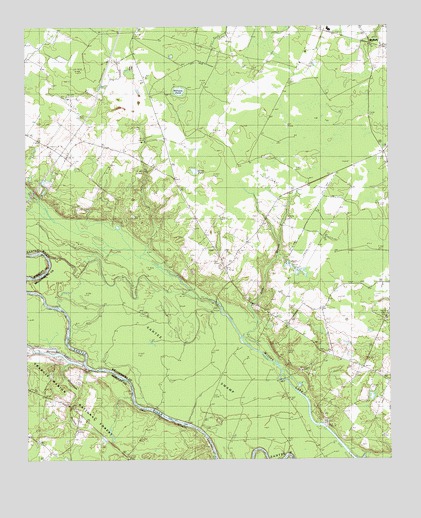
Blakely, SC USGS Topographic Map
Click on map above to begin viewing in our Map Viewer.

This topographic map contains these locations and features:
Feature Name Type Latitude Longitude GNIS ID View Map
Betaw ChurchChurchN33.3871°W79.8551°1246755View Map
Betaw Plantation (historical)LocaleN33.3863°W79.8526°1235259View Map
Betaw Plantation CemeteryCemeteryN33.3868°W79.8540°1234272View Map
Billy Cox Lower Pond Dam D-3089DamN33.4352°W79.7815°1239699View Map
Billy Cox Upper PondReservoirN33.4335°W79.7731°1239701View Map
Billy Cox Upper Pond Dam D-3090DamN33.4335°W79.7731°1239700View Map
BlakelyPopulated PlaceN33.4946°W79.7567°1231061View Map
Chapel BranchStreamN33.4335°W79.8356°1241400View Map
Charity ChurchChurchN33.4046°W79.7651°1247256View Map
Crawl CreekStreamN33.4024°W79.8556°1247420View Map
D P Cooper Elementary SchoolSchoolN33.4990°W79.7700°2486508View Map
Doctor Pond SchoolSchoolN33.3824°W79.8720°1229641View Map
Dog Creek FlatsFlatN33.4029°W79.8226°1241407View Map
Floricane (historical)Populated PlaceN33.4271°W79.8687°1234301View Map
Honey Hill ChurchChurchN33.4807°W79.8334°1229813View Map
Horse PondLakeN33.4584°W79.8167°1229822View Map
Jerusalem African Methodist Episcopal ChurchChurchN33.4363°W79.8106°1241438View Map
Jerusalem SchoolSchoolN33.4377°W79.8120°1229855View Map
June BranchStreamN33.4091°W79.7992°1229873View Map
Lane DivisionCivilN33.4953°W79.8320°1938327View Map
Laurel Hill Boat RampLocaleN33.3793°W79.8120°1230572View Map
Matassee (historical)Populated PlaceN33.4010°W79.8656°1234337View Map
Mattassee BranchStreamN33.4043°W79.8623°1246558View Map
Mattassee LakeLakeN33.4060°W79.8642°1229978View Map
Saint Peter ChurchChurchN33.4152°W79.7848°1250683View Map
Scott Woods PlantationLocaleN33.4927°W79.7781°1241515View Map
South Carolina Gun ClubLocaleN33.3791°W79.7598°1242471View Map
Sutton CemeteryCemeteryN33.4063°W79.7706°1241524View Map
Sutton ChurchChurchN33.4074°W79.7704°1251081View Map
Sutton School (historical)SchoolN33.4054°W79.7726°1241525View Map
Terry SchoolSchoolN33.4941°W79.8384°1230401View Map
Wee Tee School (historical)SchoolN33.4527°W79.8209°1241535View Map
Williams PondLakeN33.4815°W79.8217°1230503View Map
Williamsburg County Fire Department SuttonsBuildingN33.4131°W79.7832°2368446View Map
Williamsburg-Blakely Elementary/Middle SchoolSchoolN33.4993°W79.7701°1241537View Map
Wittee LakeLakeN33.3973°W79.7848°1230468View Map

Note: Coordinates in the location and feature list above are referenced to NAD83 datum.


Copyright (C) 2008-2025 Ryan Niemi / Sunset Dynamics ... All Rights Reserved