TopoQuest Logo
Do you find TopoQuest useful?
Help keep TopoQuest running and adding new maps/features by donating!
Bitcoin:  19c7KJd3qBynnjoSw5npx9KScwjBe4ifkT
Litecoin:  LXs6TkuXGGXo1vDsWCkWVdjQX94eUKd6ui
Home View Maps Find Maps Find Places Resources & Links


Greeleyville, South Carolina Topographic Map

USGS Map Title: Greeleyville, SC
USGS Map MRC: 33079E8
DRG (GeoTIFF) Download: o33079e8.tif


Neighboring USGS Topographic Map Quads:


  Foreston, SC  
33080F1
 

  Workman, SC  
33079F8
 

  Kingstree, SC  
33079F7
 

  Butlers Bay, SC  
33080E1
 

  Greeleyville, SC  
33079E8
 

  Salters, SC  
33079E7
 

  Pineville, SC  
33080D1
 

  Saint Stephen, SC  
33079D8
 

  Blakely, SC  
33079D7


Map MRC Location:

N34°
W80°
N34°
W79°
H8 H7 H6 H5 H4 H3 H2 H1
G8 G7 G6 G5 G4 G3 G2 G1
F8 F7 F6 F5 F4 F3 F2 F1
E8 E7 E6 E5 E4 E3 E2 E1
D8 D7 D6 D5 D4 D3 D2 D1
C8 C7 C6 C5 C4 C3 C2 C1
B8 B7 B6 B5 B4 B3 B2 B1
A8 A7 A6 A5 A4 A3 A2 A1
N33°
W80°
N33°
W79°

Greeleyville, SC USGS 1:24K Topographic Map Preview:
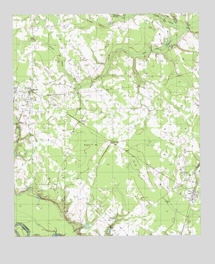
Greeleyville, SC USGS Topographic Map
Click on map above to begin viewing in our Map Viewer.

This topographic map contains these locations and features:
Feature Name Type Latitude Longitude GNIS ID View Map
Antioch ChurchChurchN33.5316°W79.8848°1244896View Map
Bennett SwampStreamN33.6229°W79.9259°1246740View Map
Bethel ChurchChurchN33.5066°W79.9365°1241374View Map
Bethel SchoolSchoolN33.5060°W79.9359°1220583View Map
Burgess BayBasinN33.5496°W79.9509°1221131View Map
C E Murray High SchoolSchoolN33.5838°W79.9990°1241388View Map
Campbell BranchStreamN33.5074°W79.9720°1221275View Map
Chaney SwampStreamN33.6024°W79.9179°1247247View Map
Dickey ChapelChurchN33.6204°W79.9245°1247528View Map
EdwardsPopulated PlaceN33.5643°W79.9548°1222243View Map
Federal Correctional Institution WilliamsburgBuildingN33.5888°W79.8780°2489766View Map
Goins SchoolSchoolN33.6216°W79.9945°1222737View Map
GreeleyvillePopulated PlaceN33.5810°W79.9890°1245822View Map
Greeleyville ChurchChurchN33.5966°W79.9862°1222860View Map
Greeleyville DivisionCivilN33.6009°W79.9873°1938283View Map
Greeleyville Elementary SchoolSchoolN33.5759°W79.9909°1241420View Map
Greeleyville Police DepartmentBuildingN33.5809°W79.9891°2334858View Map
Greeleyville Post OfficePost OfficeN33.5820°W79.9890°2489832View Map
HeinemanPopulated PlaceN33.5527°W79.9334°1245948View Map
Heineman School (historical)SchoolN33.5432°W79.9415°1241424View Map
Holliman SwampStreamN33.5857°W79.9565°1246013View Map
LanePopulated PlaceN33.5216°W79.8787°1246290View Map
Lane Fire TowerTowerN33.5210°W79.9154°1242433View Map
Lane Post OfficePost OfficeN33.5229°W79.8790°1252253View Map
Lane Town HallBuildingN33.5808°W79.9891°2490462View Map
Laws Swamp ChurchChurchN33.6204°W79.8829°1223845View Map
Long Lands PlantationLocaleN33.5166°W79.9423°1241453View Map
Longlands Hope Swamp PondReservoirN33.5279°W79.9908°1239712View Map
Longlands House PondReservoirN33.5056°W79.9510°1238735View Map
Mount Hope CemeteryCemeteryN33.5557°W79.9890°1241467View Map
Mount Hope ChurchChurchN33.5563°W79.9887°1224717View Map
Mount Zion ChurchChurchN33.5299°W79.9856°1241470View Map
Mount Zion ChurchChurchN33.6002°W79.9512°1224822View Map
Mount Zion SchoolSchoolN33.5299°W79.9865°1224846View Map
Mulberry BranchStreamN33.6227°W79.9259°1224879View Map
New Market (historical)Populated PlaceN33.5335°W79.9973°1241480View Map
Richmond CemeteryCemeteryN33.5265°W79.9726°1241492View Map
Richmond ChurchChurchN33.5243°W79.9642°1225872View Map
Rock Hill ChurchChurchN33.5504°W79.8851°1225930View Map
Rocky Ford SwampStreamN33.6166°W79.8798°1250446View Map
Saint Agey ChurchChurchN33.5868°W79.9595°1226089View Map
Shanty BranchStreamN33.6182°W79.8901°1226535View Map
South Carolina Noname 45005 D-3081 DamDamN33.5052°W79.9498°1238734View Map
South Carolina Noname 45009 D-3082 DamDamN33.5152°W79.9648°1238737View Map
Spring Hill Church (historical)ChurchN33.5668°W79.9345°1241522View Map
Town of GreeleyvilleCivilN33.5802°W79.9900°2406609View Map
Town of LaneCivilN33.5251°W79.8797°2405984View Map
Trinity Baptist ChurchChurchN33.5688°W79.9884°1251207View Map
Union ChurchChurchN33.5710°W79.9045°1241531View Map
Union SchoolSchoolN33.5707°W79.9048°1227308View Map
Walnut BranchStreamN33.5010°W79.9712°1227383View Map
Webber PondReservoirN33.5030°W79.9366°1239721View Map
Webber Pond Dam D-3083DamN33.5018°W79.9365°1239720View Map
WHLZ-FM (Manning)TowerN33.5349°W79.9873°1252516View Map
Williamsburg County Fire Department GreeleyvilleBuildingN33.5809°W79.9891°2368278View Map
Williamsburg County Volunteer Fire DepartmentBuildingN33.5231°W79.8789°2368350View Map

Note: Coordinates in the location and feature list above are referenced to NAD83 datum.


Copyright (C) 2008-2025 Ryan Niemi / Sunset Dynamics ... All Rights Reserved