TopoQuest Logo
Do you find TopoQuest useful?
Help keep TopoQuest running and adding new maps/features by donating!
Bitcoin:  19c7KJd3qBynnjoSw5npx9KScwjBe4ifkT
Litecoin:  LXs6TkuXGGXo1vDsWCkWVdjQX94eUKd6ui
Home View Maps Find Maps Find Places Resources & Links


Stokesville, Virginia Topographic Map

USGS Map Title: Stokesville, VA
USGS Map MRC: 38079C2
DRG (GeoTIFF) Download: o38079c2.tif


Neighboring USGS Topographic Map Quads:


  Palo Alto, VA  
38079D3
 

  Reddish Knob, VA  
38079D2
 

  Briery Branch, VA  
38079D1
 

  West Augusta, VA  
38079C3
 

  Stokesville, VA  
38079C2
 

  Parnassus, VA  
38079C1
 

  Elliott Knob, VA  
38079B3
 

  Churchville, VA  
38079B2
 

  Staunton, VA  
38079B1


Map MRC Location:

N39°
W80°
N39°
W79°
H8 H7 H6 H5 H4 H3 H2 H1
G8 G7 G6 G5 G4 G3 G2 G1
F8 F7 F6 F5 F4 F3 F2 F1
E8 E7 E6 E5 E4 E3 E2 E1
D8 D7 D6 D5 D4 D3 D2 D1
C8 C7 C6 C5 C4 C3 C2 C1
B8 B7 B6 B5 B4 B3 B2 B1
A8 A7 A6 A5 A4 A3 A2 A1
N38°
W80°
N38°
W79°

Stokesville, VA USGS 1:24K Topographic Map Preview:
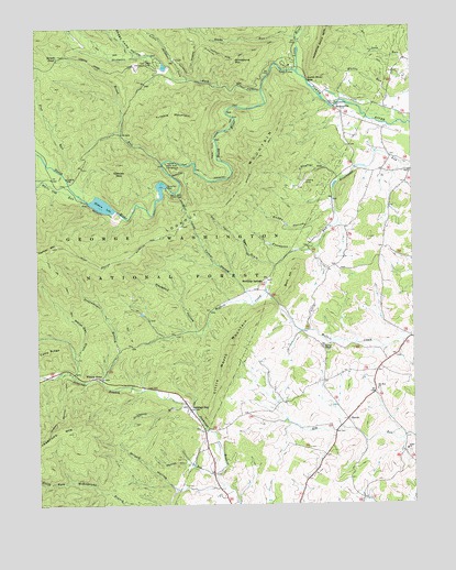
Stokesville, VA USGS Topographic Map
Click on map above to begin viewing in our Map Viewer.

This topographic map contains these locations and features:
Feature Name Type Latitude Longitude GNIS ID View Map
Barger PondLakeN38.3676°W79.2439°1481455View Map
Bear DraftValleyN38.3125°W79.1705°1481515View Map
Bear Draft TrailTrailN38.3207°W79.1848°1481516View Map
Bear Trap FarmLocaleN38.3617°W79.1269°2647380View Map
Broad RunStreamN38.3398°W79.2086°1482013View Map
Buck HillSummitN38.3115°W79.1634°1482109View Map
Camp FlatherLocaleN38.3648°W79.1656°1482258View Map
Coal RunStreamN38.3710°W79.1634°1482605View Map
Daggy Camp HollowValleyN38.3691°W79.2169°1482894View Map
Delta Springs FarmLocaleN38.3353°W79.1336°2647382View Map
Echols Airport (historical)AirportN38.3346°W79.1603°1498598View Map
Elk Run ChurchChurchN38.2798°W79.1370°1483283View Map
Elkhorn LakeReservoirN38.3288°W79.2279°1502010View Map
Elkhorn MountainSummitN38.3393°W79.2236°1483285View Map
Flat RunStreamN38.3304°W79.2350°1483446View Map
Grindstone MountainSummitN38.3668°W79.1842°1483841View Map
Hankey MountainSummitN38.3176°W79.2453°1483928View Map
Hankey Mountain TrailTrailN38.3137°W79.2320°1483929View Map
Haywood HollowValleyN38.2958°W79.1973°1483999View Map
Jennings GapGapN38.2835°W79.2295°1739630View Map
Jennings GapGapN38.2754°W79.1998°1484415View Map
Jennings Gap DairyLocaleN38.2878°W79.1517°2676016View Map
Little North MountainSummitN38.2918°W79.1856°1484944View Map
Little RiverStreamN38.3637°W79.1636°1484965View Map
Little Skidmore ForkStreamN38.3618°W79.1998°1484975View Map
Little Skidmore TrailTrailN38.3662°W79.1975°1484976View Map
Lookout MountainSummitN38.3412°W79.1761°1485079View Map
Lookout Mountain TrailTrailN38.3373°W79.1781°1485080View Map
Muddy HollowValleyN38.3278°W79.1508°1485742View Map
North River CampgroundLocaleN38.3396°W79.2073°1485917View Map
North River DistrictCivilN38.3265°W79.1490°1927427View Map
North River GapGapN38.3610°W79.1600°1485918View Map
North River Gorge TrailTrailN38.3476°W79.1889°1485919View Map
North River Picnic AreaLocaleN38.3321°W79.2053°1485920View Map
Paynes ChapelChurchN38.2912°W79.1548°1486100View Map
Shaffer HollowValleyN38.3382°W79.1537°1487023View Map
Skidmore ForkStreamN38.3579°W79.1750°1487285View Map
Staunton DamDamN38.3335°W79.2064°1502137View Map
Staunton ReservoirReservoirN38.3335°W79.2081°1489197View Map
Stillhouse RunStreamN38.2760°W79.2003°1487584View Map
StokesvillePopulated PlaceN38.3526°W79.1489°1487591View Map
Stony RunStreamN38.3721°W79.1636°1487639View Map
Stoutameyer BranchStreamN38.2823°W79.2289°1487648View Map
StoverPopulated PlaceN38.2721°W79.1470°1487649View Map
Stribling SpringsPopulated PlaceN38.3087°W79.1745°1500181View Map
Swoope RunStreamN38.2571°W79.1911°1487757View Map
Todd LakeReservoirN38.3648°W79.2068°1739675View Map
Todd Lake Camp SiteLocaleN38.3690°W79.2131°1488670View Map
Todd Lake Recreation AreaLocaleN38.3660°W79.2117°1487938View Map
Trimble MountainSummitN38.3512°W79.2117°1500236View Map
Tunnel HollowValleyN38.3102°W79.1843°1488013View Map
Union ChurchChurchN38.2640°W79.1289°1488063View Map
Upper North River Number 10 DamDamN38.3668°W79.2081°1489178View Map
Upper North River Number 76 DamDamN38.3301°W79.2248°1489179View Map
White Oak DraftValleyN38.2843°W79.2371°1488292View Map
White Oak Draft TrailTrailN38.3026°W79.2395°1488294View Map
White Oak RunStreamN38.3296°W79.2334°1488300View Map
Whites StoreLocaleN38.2832°W79.2298°1488339View Map
Wilson HollowValleyN38.2557°W79.2071°1488419View Map

Note: Coordinates in the location and feature list above are referenced to NAD83 datum.


Copyright (C) 2008-2024 Ryan Niemi / Sunset Dynamics ... All Rights Reserved