TopoQuest Logo
Do you find TopoQuest useful?
Help keep TopoQuest running and adding new maps/features by donating!
Bitcoin:  19c7KJd3qBynnjoSw5npx9KScwjBe4ifkT
Litecoin:  LXs6TkuXGGXo1vDsWCkWVdjQX94eUKd6ui
Home View Maps Find Maps Find Places Resources & Links


Parnassus, Virginia Topographic Map

USGS Map Title: Parnassus, VA
USGS Map MRC: 38079C1
DRG (GeoTIFF) Download: o38079c1.tif


Neighboring USGS Topographic Map Quads:


  Reddish Knob, VA  
38079D2
 

  Briery Branch, VA  
38079D1
 

  Bridgewater, VA  
38078D8
 

  Stokesville, VA  
38079C2
 

  Parnassus, VA  
38079C1
 

  Mount Sidney, VA  
38078C8
 

  Churchville, VA  
38079B2
 

  Staunton, VA  
38079B1
 

  Fort Defiance, VA  
38078B8


Map MRC Location:

N39°
W80°
N39°
W79°
H8 H7 H6 H5 H4 H3 H2 H1
G8 G7 G6 G5 G4 G3 G2 G1
F8 F7 F6 F5 F4 F3 F2 F1
E8 E7 E6 E5 E4 E3 E2 E1
D8 D7 D6 D5 D4 D3 D2 D1
C8 C7 C6 C5 C4 C3 C2 C1
B8 B7 B6 B5 B4 B3 B2 B1
A8 A7 A6 A5 A4 A3 A2 A1
N38°
W80°
N38°
W79°

Parnassus, VA USGS 1:24K Topographic Map Preview:
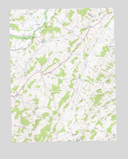
Parnassus, VA USGS Topographic Map
Click on map above to begin viewing in our Map Viewer.

This topographic map contains these locations and features:
Feature Name Type Latitude Longitude GNIS ID View Map
Castle HillSummitN38.3485°W79.0970°1496834View Map
CentervillePopulated PlaceN38.3385°W79.0056°1496838View Map
Elk RunStreamN38.2604°W79.1028°1483280View Map
Emmanuel ChurchChurchN38.3704°W79.0986°1466292View Map
Freemason RunStreamN38.3512°W79.0950°1483535View Map
Gardner's Dairy and Poultry FarmLocaleN38.3044°W79.0767°2647376View Map
Glade ValleyValleyN38.3433°W79.0138°1467120View Map
Hidden Acres FarmLocaleN38.2972°W79.1011°2647384View Map
Hillview FarmLocaleN38.3664°W79.0189°2676004View Map
Lebanon ChurchChurchN38.2543°W79.0128°1469252View Map
Lick RunStreamN38.3718°W79.0817°1484833View Map
Michaels Poultry FarmLocaleN38.3519°W79.1014°2647374View Map
MoscowPopulated PlaceN38.3171°W79.0889°1477556View Map
Mossy CreekLocaleN38.3573°W79.0286°1470787View Map
Mossy Creek ChurchChurchN38.3532°W79.0492°1470788View Map
Mossy Creek Poultry FarmLocaleN38.3478°W79.0589°2647372View Map
Mount Olivet ChurchChurchN38.3371°W79.1225°1471009View Map
Mount PisgahPopulated PlaceN38.2535°W79.0028°1497027View Map
Mount SolonPopulated PlaceN38.3448°W79.0850°1497028View Map
Mount Solon ChurchChurchN38.3507°W79.1084°1471073View Map
Mount Solon Post OfficePost OfficeN38.3427°W79.0849°2766255View Map
Mount Solon Volunteer Fire and Rescue Squad Company 21 Rescue 21BuildingN38.3606°W79.0910°2075617View Map
Mount Solon Volunteer Rescue SquadBuildingN38.3617°W79.0917°2075594View Map
Natural ChimneysPillarN38.3587°W79.0825°1471343View Map
Natural Chimneys Regional ParkParkN38.3585°W79.0831°1739649View Map
North River Elementary SchoolSchoolN38.3147°W79.0790°1471641View Map
ParnassusPopulated PlaceN38.2948°W79.1181°1497074View Map
Possum HollowValleyN38.3310°W79.0532°1472694View Map
RomanPopulated PlaceN38.2826°W79.0150°1497124View Map
Saint Pauls ChurchChurchN38.3490°W79.1056°1473888View Map
Spring HillPopulated PlaceN38.2562°W79.0525°1497159View Map
TowersLocaleN38.3607°W79.0886°1475803View Map
Weaver Brothers DairyLocaleN38.3481°W79.0078°2676010View Map
Whites RunStreamN38.3557°W79.0920°1488338View Map

Note: Coordinates in the location and feature list above are referenced to NAD83 datum.


Copyright (C) 2008-2025 Ryan Niemi / Sunset Dynamics ... All Rights Reserved