TopoQuest Logo
Do you find TopoQuest useful?
Help keep TopoQuest running and adding new maps/features by donating!
Bitcoin:  19c7KJd3qBynnjoSw5npx9KScwjBe4ifkT
Litecoin:  LXs6TkuXGGXo1vDsWCkWVdjQX94eUKd6ui
Home View Maps Find Maps Find Places Resources & Links


Stony Ridge, Colorado Topographic Map

USGS Map Title: Stony Ridge, CO
USGS Map MRC: 39107C3
DRG (GeoTIFF) Download: o39107c3.tif


Neighboring USGS Topographic Map Quads:


  Center Mountain, CO  
39107D4
 

  Cattle Creek, CO  
39107D3
 

  Carbondale, CO  
39107D2
 

  Quaker Mesa, CO  
39107C4
 

  Stony Ridge, CO  
39107C3
 

  Mount Sopris, CO  
39107C2
 

  Elk Knob, CO  
39107B4
 

  Placita, CO  
39107B3
 

  Redstone, CO  
39107B2


Map MRC Location:

N40°
W108°
N40°
W107°
H8 H7 H6 H5 H4 H3 H2 H1
G8 G7 G6 G5 G4 G3 G2 G1
F8 F7 F6 F5 F4 F3 F2 F1
E8 E7 E6 E5 E4 E3 E2 E1
D8 D7 D6 D5 D4 D3 D2 D1
C8 C7 C6 C5 C4 C3 C2 C1
B8 B7 B6 B5 B4 B3 B2 B1
A8 A7 A6 A5 A4 A3 A2 A1
N39°
W108°
N39°
W107°

Stony Ridge, CO USGS 1:24K Topographic Map Preview:
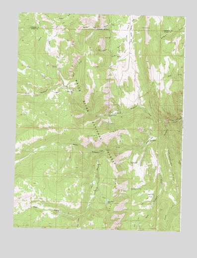
Stony Ridge, CO USGS Topographic Map
Click on map above to begin viewing in our Map Viewer.

This topographic map contains these locations and features:
Feature Name Type Latitude Longitude GNIS ID View Map
Anderson MineMineN39.2961°W107.3076°174997View Map
Aspen GulchValleyN39.3573°W107.2921°175007View Map
Assignation RidgeRidgeN39.2917°W107.2584°174991View Map
Calf CreekStreamN39.3319°W107.3492°174999View Map
Dexter CreekStreamN39.2578°W107.3251°174994View Map
Jerome ParkFlatN39.3650°W107.2937°175004View Map
Lake Ridge LakesReservoirN39.2658°W107.3059°174987View Map
Lambert PlaceLocaleN39.3289°W107.3467°175000View Map
Marion CemeteryCemeteryN39.3689°W107.3053°175005View Map
Marion GulchValleyN39.3717°W107.3015°175002View Map
Marion MineMineN39.3672°W107.3167°175009View Map
Middle Thompson CreekStreamN39.3036°W107.2684°174955View Map
North Thompson CreekStreamN39.3133°W107.2598°174964View Map
Parsnip FlatFlatN39.2708°W107.2728°175011View Map
Sand CreekStreamN39.3319°W107.3381°175003View Map
South Branch Middle Thompson CreekStreamN39.2950°W107.3095°174958View Map
South Thompson CreekStreamN39.3036°W107.2684°174985View Map
South Thompson Creek Cow CampLocaleN39.2739°W107.2887°174988View Map
Spring GulchValleyN39.3573°W107.2921°175006View Map
Spring Gulch MineMineN39.3444°W107.3123°1684129View Map
Stony RidgeRidgeN39.3050°W107.3392°174995View Map
Sunshine MineMineN39.2953°W107.3087°174996View Map
Thompson Creek Guard StationLocaleN39.2897°W107.2837°174992View Map
Thompson Creek MineMineN39.3172°W107.3059°174998View Map
Thompson Creek Number One MineMineN39.3178°W107.3056°1684130View Map
Thompson Creek Number Three MineMineN39.3180°W107.3103°1684128View Map
Union MineMineN39.3541°W107.3131°175008View Map
Willow ParkFlatN39.3030°W107.2748°174993View Map
Yank CreekStreamN39.3328°W107.3401°174823View Map
Yank Creek Cow CampLocaleN39.3439°W107.3453°175001View Map

Note: Coordinates in the location and feature list above are referenced to NAD83 datum.


Copyright (C) 2008-2025 Ryan Niemi / Sunset Dynamics ... All Rights Reserved