TopoQuest Logo
Do you find TopoQuest useful?
Help keep TopoQuest running and adding new maps/features by donating!
Bitcoin:  19c7KJd3qBynnjoSw5npx9KScwjBe4ifkT
Litecoin:  LXs6TkuXGGXo1vDsWCkWVdjQX94eUKd6ui
Home View Maps Find Maps Find Places Resources & Links


Strawberry, Arizona Topographic Map

USGS Map Title: Strawberry, AZ
USGS Map MRC: 34111D5
DRG (GeoTIFF) Download: o34111d5.tif


Neighboring USGS Topographic Map Quads:


  Walker Mountain, AZ  
34111E6
 

  Buckhorn Mountain, AZ  
34111E5
 

  Calloway Butte, AZ  
34111E4
 

  Hackberry Mountain, AZ  
34111D6
 

  Strawberry, AZ  
34111D5
 

  Pine, AZ  
34111D4
 

  Verde Hot Springs, AZ  
34111C6
 

  Cane Springs Mountain, AZ  
34111C5
 

  Buckhead Mesa, AZ  
34111C4


Map MRC Location:

N35°
W112°
N35°
W111°
H8 H7 H6 H5 H4 H3 H2 H1
G8 G7 G6 G5 G4 G3 G2 G1
F8 F7 F6 F5 F4 F3 F2 F1
E8 E7 E6 E5 E4 E3 E2 E1
D8 D7 D6 D5 D4 D3 D2 D1
C8 C7 C6 C5 C4 C3 C2 C1
B8 B7 B6 B5 B4 B3 B2 B1
A8 A7 A6 A5 A4 A3 A2 A1
N34°
W112°
N34°
W111°

Strawberry, AZ USGS 1:24K Topographic Map Preview:
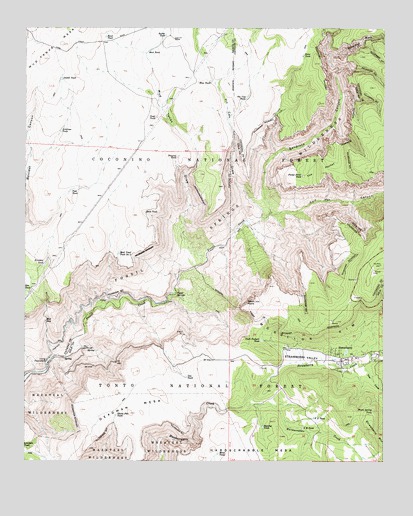
Strawberry, AZ USGS Topographic Map
Click on map above to begin viewing in our Map Viewer.

This topographic map contains these locations and features:
Feature Name Type Latitude Longitude GNIS ID View Map
Antelope TankReservoirN34.4702°W111.6133°25681View Map
Blackies TankReservoirN34.4759°W111.5563°38258View Map
Blue TankReservoirN34.4844°W111.5612°26538View Map
Calf Pen CanyonValleyN34.4470°W111.5338°27175View Map
Charleys TankReservoirN34.4340°W111.6045°2056517View Map
Deadman MesaSummitN34.3911°W111.5874°28338View Map
Divide TankReservoirN34.4852°W111.6133°28492View Map
F U TankReservoirN34.3878°W111.5249°28944View Map
Fossil SpringsSpringN34.4234°W111.5740°29134View Map
Fossil Springs WildernessReserveN34.4497°W111.5397°2035124View Map
Freckles TankReservoirN34.4317°W111.6186°29173View Map
Gnat TankReservoirN34.4744°W111.5799°29346View Map
Gus TankReservoirN34.3992°W111.5691°29634View Map
Herbies TankReservoirN34.4888°W111.5615°2056515View Map
Hopeful TankReservoirN34.3914°W111.5317°39512View Map
Hopeful TankReservoirN34.3851°W111.5426°30107View Map
Horsetank WashStreamN34.4925°W111.5196°25488View Map
Irving PowerplantLocaleN34.4039°W111.6176°30431View Map
KRIM-FM (Payson)TowerN34.4300°W111.5051°45713View Map
KRMM-FM (Payson)TowerN34.4303°W111.5051°45712View Map
Lazy T-seven RanchLocaleN34.4970°W111.5743°30916View Map
Mail Trail Tank Number TwoReservoirN34.4350°W111.5930°31456View Map
Maple Spring TankReservoirN34.3891°W111.5045°31502View Map
Mesa TankReservoirN34.3773°W111.5581°31733View Map
Mogollon MesaSummitN34.4772°W111.5985°38638View Map
Mud Number One TankReservoirN34.4845°W111.5804°38650View Map
Mud SeepSpringN34.4154°W111.6183°32096View Map
Mud TankReservoirN34.4935°W111.5825°32141View Map
Mud Tanks DrawValleyN34.4339°W111.5626°32148View Map
Nash Pasture TankReservoirN34.4101°W111.5430°32245View Map
Nash PointSummitN34.4211°W111.5454°32246View Map
Natural SpringSpringN34.4581°W111.5707°41322View Map
Natural TankReservoirN34.4627°W111.5726°32248View Map
Oak TankReservoirN34.4539°W111.5801°41338View Map
Peak TankReservoirN34.4628°W111.6238°2056516View Map
Petes TankReservoirN34.4923°W111.5291°32835View Map
Pine - Strawberry Fire District Station 42BuildingN34.4068°W111.5038°2672560View Map
Pine TankReservoirN34.4533°W111.6095°32980View Map
Pocket Point TankReservoirN34.4575°W111.5290°33065View Map
Rafter TankReservoirN34.4980°W111.5769°33320View Map
Road TankReservoirN34.4975°W111.5978°33656View Map
Sandrock CanyonValleyN34.4470°W111.5401°34047View Map
Shake Pile TankReservoirN34.3885°W111.5938°34300View Map
Slate TankReservoirN34.4468°W111.5839°34523View Map
Slaughter TankLocaleN34.3920°W111.6174°39798View Map
Stan TankLocaleN34.4020°W111.5068°39811View Map
Strawberry Census Designated PlaceCensusN34.4017°W111.5002°2410012View Map
Strawberry Chapel in the PinesChurchN34.4067°W111.5044°2671827View Map
Strawberry CreekStreamN34.3903°W111.5540°34891View Map
Strawberry ValleyValleyN34.4034°W111.5349°41918View Map
The CoveValleyN34.3939°W111.5007°35219View Map
The PocketBasinN34.4592°W111.5240°35239View Map
Tin Can DrawValleyN34.4453°W111.5435°35330View Map
Tin Can TankReservoirN34.4800°W111.5486°35331View Map
Y H TankReservoirN34.3848°W111.5289°36420View Map

Note: Coordinates in the location and feature list above are referenced to NAD83 datum.


Copyright (C) 2008-2024 Ryan Niemi / Sunset Dynamics ... All Rights Reserved