TopoQuest Logo
Do you find TopoQuest useful?
Help keep TopoQuest running and adding new maps/features by donating!
Bitcoin:  19c7KJd3qBynnjoSw5npx9KScwjBe4ifkT
Litecoin:  LXs6TkuXGGXo1vDsWCkWVdjQX94eUKd6ui
Home View Maps Find Maps Find Places Resources & Links


Cane Springs Mountain, Arizona Topographic Map

USGS Map Title: Cane Springs Mountain, AZ
USGS Map MRC: 34111C5
DRG (GeoTIFF) Download: o34111c5.tif


Neighboring USGS Topographic Map Quads:


  Hackberry Mountain, AZ  
34111D6
 

  Strawberry, AZ  
34111D5
 

  Pine, AZ  
34111D4
 

  Verde Hot Springs, AZ  
34111C6
 

  Cane Springs Mountain, AZ  
34111C5
 

  Buckhead Mesa, AZ  
34111C4
 

  Wet Bottom Mesa, AZ  
34111B6
 

  Cypress Butte, AZ  
34111B5
 

  North Peak, AZ  
34111B4


Map MRC Location:

N35°
W112°
N35°
W111°
H8 H7 H6 H5 H4 H3 H2 H1
G8 G7 G6 G5 G4 G3 G2 G1
F8 F7 F6 F5 F4 F3 F2 F1
E8 E7 E6 E5 E4 E3 E2 E1
D8 D7 D6 D5 D4 D3 D2 D1
C8 C7 C6 C5 C4 C3 C2 C1
B8 B7 B6 B5 B4 B3 B2 B1
A8 A7 A6 A5 A4 A3 A2 A1
N34°
W112°
N34°
W111°

Cane Springs Mountain, AZ USGS 1:24K Topographic Map Preview:
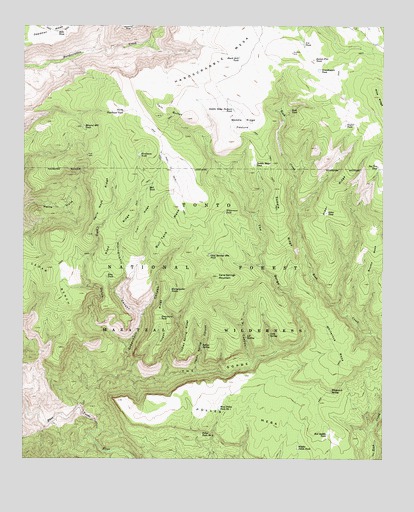
Cane Springs Mountain, AZ USGS Topographic Map
Click on map above to begin viewing in our Map Viewer.

This topographic map contains these locations and features:
Feature Name Type Latitude Longitude GNIS ID View Map
Alder RidgeRidgeN34.3264°W111.5182°25577View Map
Alder TankReservoirN34.3211°W111.5202°25580View Map
Bee Tree TankReservoirN34.3344°W111.5023°26179View Map
Big SpringSpringN34.2559°W111.5596°2044295View Map
Bills TankReservoirN34.3734°W111.6140°26336View Map
Black Jack TankReservoirN34.3660°W111.5508°26402View Map
Brushy MesaSummitN34.3006°W111.5068°26832View Map
Bull TankReservoirN34.3283°W111.5826°26980View Map
Bull Tank MesaSummitN34.3228°W111.5738°26988View Map
Button Flat TankReservoirN34.3653°W111.5249°27099View Map
Camp GulchValleyN34.2831°W111.5896°27204View Map
Cane SpringSpringN34.2859°W111.5401°27248View Map
Cane Springs MountainSummitN34.3023°W111.5582°27251View Map
Cane Springs Mountain TankReservoirN34.3090°W111.5611°27252View Map
Cedar BenchBenchN34.3067°W111.6246°27400View Map
Grasshopper TankReservoirN34.3623°W111.5231°29545View Map
Greenhorn CanyonValleyN34.2742°W111.5926°29588View Map
Greenhorn TankReservoirN34.2908°W111.5780°29589View Map
Hardscrabble MesaSummitN34.3673°W111.5557°29747View Map
Hells Neck RidgeRidgeN34.3267°W111.5976°29879View Map
Hieroglyphic CanyonValleyN34.2917°W111.5846°29960View Map
Hieroglyphic TanksReservoirN34.2986°W111.5743°29962View Map
Hogan RidgeRidgeN34.2911°W111.5799°30037View Map
Indian SpringSpringN34.2826°W111.5636°30363View Map
Indian Spring CanyonValleyN34.2753°W111.5657°30367View Map
Indian Spring RidgeRidgeN34.2873°W111.5688°30370View Map
L P CanyonValleyN34.2781°W111.5457°30818View Map
L P SpringSpringN34.2853°W111.5482°30819View Map
Middle Polles TankReservoirN34.2532°W111.5302°31820View Map
Mineral Hill TankReservoirN34.3458°W111.6048°31908View Map
Mogollon RimCliffN34.2503°W111.5985°31945View Map
North TankReservoirN34.3504°W111.5909°32391View Map
Plowbeam TankReservoirN34.3378°W111.5856°40845View Map
Polles MesaSummitN34.2742°W111.5485°33090View Map
Polles TankReservoirN34.2571°W111.5636°33091View Map
Red Saddle TankReservoirN34.2573°W111.5199°33512View Map
Road RidgeRidgeN34.3153°W111.5938°33652View Map
Rock TankReservoirN34.3509°W111.5330°33738View Map
Ross TankReservoirN34.3028°W111.5968°33814View Map
Saddle CorralLocaleN34.3098°W111.5310°39764View Map
Saddle RidgeRidgeN34.3186°W111.5360°33930View Map
Saddle Ridge PastureFlatN34.3470°W111.5496°33931View Map
Saddle Ridge Pasture TankReservoirN34.3510°W111.5529°33932View Map
Saddle Ridge TankReservoirN34.3350°W111.5455°33933View Map
Squaw Basin TankReservoirN34.2907°W111.6115°39809View Map
Taylor TankReservoirN34.3464°W111.5139°35168View Map
The GorgeValleyN34.2653°W111.6054°35224View Map
Trail RidgeRidgeN34.3192°W111.5849°35431View Map
Twin ButtesSummitN34.3492°W111.5799°35614View Map
U A TankReservoirN34.3700°W111.5285°35650View Map
West Polles TankReservoirN34.2646°W111.5577°36014View Map
Whiterock MesaSummitN34.2834°W111.5174°36124View Map
Whiterock SpringSpringN34.2696°W111.5186°36125View Map
Wilderness TankReservoirN34.3211°W111.5558°36198View Map

Note: Coordinates in the location and feature list above are referenced to NAD83 datum.


Copyright (C) 2008-2025 Ryan Niemi / Sunset Dynamics ... All Rights Reserved